Rottenmann and Wölz Tauern | |
---|---|
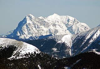
The Rettlkirchspitze, the highest summit in the range. | |
Highest point | |
Peak | Rettlkirchspitze |
Elevation | 2,475 m above sea level (AA) |
Geography | |
State | Styria, Austria |
Range coordinates | 47°15′36″N14°07′39″E / 47.26000°N 14.12750°E Coordinates: 47°15′36″N14°07′39″E / 47.26000°N 14.12750°E |
Parent range | Low Tauern |
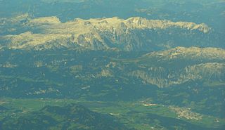
The Rottenmann and Wölz Tauern [1] [2] (German : Rottenmanner und Wölzer Tauern) are a subrange of the Austrian Central Alps within the Eastern Alps. Together with the Radstadt Tauern, the Schladming Tauern and the Seckau Tauern the Rottenmann and Wölz Tauern form the major range known as the Low Tauern. The mountains are located in Austria in the federal state of Styria.
German is a West Germanic language that is mainly spoken in Central Europe. It is the most widely spoken and official or co-official language in Germany, Austria, Switzerland, South Tyrol (Italy), the German-speaking Community of Belgium, and Liechtenstein. It is also one of the three official languages of Luxembourg and a co-official language in the Opole Voivodeship in Poland. The languages which are most similar to German are the other members of the West Germanic language branch: Afrikaans, Dutch, English, the Frisian languages, Low German/Low Saxon, Luxembourgish, and Yiddish. There are also strong similarities in vocabulary with Danish, Norwegian and Swedish, although those belong to the North Germanic group. German is the second most widely spoken Germanic language, after English.
Eastern Alps is the name given to the eastern half of the Alps, usually defined as the area east of a line from Lake Constance and the Alpine Rhine valley up to the Splügen Pass at the Alpine divide and down the Liro River to Lake Como in the south. The peaks and mountain passes are lower compared to the Western Alps, while the range itself is broader and less arched.
The Radstadt Tauern are a subrange of the Central Eastern Alps in Austria. Together with the Schladming Tauern, the Rottenmann and Wölz Tauern and the Seckau Tauern the Radstadt Tauern form the major range of mountains known as the Low Tauern. The mountains are found in the southeast of the Austrian state of Salzburg, between the upper reaches of the Enns and Mur rivers.
Greim, at 2,474 m (8,117 ft), is a mountain in the Wölzer Tauern, part of the Niedere Tauern, in Styria, Austria. After the Rettelkirchspitze, it is the second highest elevation of the Wölzer Tauern.
Großer Bösenstein is a mountain of the Lower Tauern in Styria, Austria. It is located near the village of Hohentauern, which is the starting point for most climbs, and is the third highest mountain of the Rottenmann and Wölz Tauern sub-range. It is a hiking peak, and the view from the summit provides an excellent view of the far Eastern Alps, including Grimming and the Totes Gebirge.
The Rottenmann Tauern and Wölz Tauern border on the following other mountain ranges of the Alps:
The Totes Gebirge is a group of mountains in Austria, part of the Northern Limestone Alps, lying between the Salzkammergut and the Ennstaler Alpen. The name Totes Gebirge is derived from the German words tot meaning "dead", referring to the apparent lack of vegetation, and Gebirge meaning "mountain range". The area is a large karst plateau with steep sides, and several mountain peaks above 2000 m. The highest point is the summit of Großer Priel, at 2,515 metres (8,251 ft)
The Ennstal Alps, the Alps of the Enns valley, are a mountain range of the Northern Limestone Alps System. They are located primarily in the Austrian state of Styria, and also into the state of Upper Austria.
The Seckau Tauern or Seckau Alps are a small subrange of the Low Tauern mountains in the Austrian Central Alps, part of the Eastern Alps. The range is located in the Austria state of Styria.
The Kitzbühel Alps are a mountain range of the Central Eastern Alps surrounding the town of Kitzbühel in Tyrol, Austria. Geologically they are part of the western slate zone.
The Kreuzeck Group is a mountain range of the Central Eastern Alps. It may be considered either a separate range or part of the larger High Tauern chain. Administratively, the range belongs to the Austrian states of Carinthia and, in the westernmost part, Tyrol.
The Lower Tauern or Niedere Tauern are a mountain range of the Central Eastern Alps, in the Austrian states of Salzburg and Styria.
Radstädter Tauern Pass is a high mountain pass in the Austrian state of Salzburg, connecting the town of Radstadt in the Pongau region with Mauterndorf in Lungau.
Rottenmann is a town in Styria in Austria, near the Rottenmanner Tauern. Rottenmann was first referred to in an document in 927. It received its town charter in 1279 from King Rudolf von Habsburg.
Gaishorn am See is a municipality in the district of Liezen in the Austrian state of Styria.
The Dachstein Mountains are a mountain range in the Northern Limestone Alps.
The Ankogel Group is a sub-group of the Central Eastern Alps. Together with the Goldberg Group, the Glockner Group, the Schober Group, the Kreuzeck Group, the Granatspitze Group, the Venediger Group, the Villgraten Mountains and the Rieserferner Group it forms the mountain range of the Hohe Tauern.
The Carnic and Gailtal Alps is a geographic grouping of mountain ranges belonging to the Southern Limestone Alps. They are located in Austria and Italy.
The Hochgolling is a mountain of the Eastern Alps, located on the border of Steiermark and Salzburg, Austria, near the ski resort of Schladming. It is the highest peak of the Lower Tauern range.
The Goldberg Group is a sub-group of the Hohe Tauern mountain range within the Central Eastern Alps. It is located in Austria, in the states of Salzburg and Carinthia. Its highest peak is the Hocharn, 3,254 m (AA). Other well known summits are the Hoher Sonnblick, with its observatory at 3,106 m above sea level (AA), and the Schareck at 3,123 m above sea level (AA)
The Schladming Tauern are a subrange of the Austrian Central Alps within the Eastern Alps. Together with the Radstadt Tauern, the Rottenmann and Wölz Tauern and the Seckau Tauern the Schladming Tauern form the major range known as the Low Tauern. The mountains are located in Austria in the federal states of Salzburg and Styria. Its highest peak, at 2,862 m is the Hochgolling.
Plattenspitze or Plattenspitz may refer to the following mountains in central Europe:
The word Tauern is German and originally meant "high mountain pass" in the Austrian Central Alps, referring to the many bridleways and passes of the parallel side valleys of the River Salzach that cut into the mountain ranges. From the Middle Ages, when mining reached its heyday, the word "Tauern" was also used to name the corresponding ranges. The name has survived in many local placenames today.
The Hochwildstelle or Hohe Wildstelle is a mountain, 2,747 m (AA), and the second highest peak in the Schladming Tauern as well as the highest mountain entirely on Styrian territory in Austria. Its summit is near the tripoint of the three municipalities of Aich, Michaelerberg-Pruggern and Schladming.
Sölk is a municipality since 2015 in the Liezen District of Styria, Austria.
The International Standard Book Number (ISBN) is a numeric commercial book identifier which is intended to be unique. Publishers purchase ISBNs from an affiliate of the International ISBN Agency.
![]() | Wikimedia Commons has media related to Rottenmann and Wölz Tauern . |