This article relies largely or entirely on a single source .(January 2026) |
Roxbury, Wisconsin | |
|---|---|
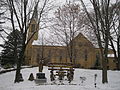
 Entering Roxbury on County Highway Y | |
 Roxbury  Roxbury | |
| Coordinates: 43°14′58″N89°40′31″W / 43.24944°N 89.67528°W | |
| Country | |
| State | |
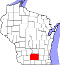
| County | Dane County |
| Town | Roxbury |
| Elevation | 866 ft (264 m) |
| Time zone | UTC-6 (Central (CST)) |
| • Summer (DST) | UTC-5 (CDT) |
| Area code | 608 |
| GNIS feature ID | 1572693 [1] |
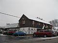
Roxbury is an unincorporated community located in the town of Roxbury, Dane County, Wisconsin, United States. [1]