Monona, Wisconsin

Last updated
Monona, Wisconsin
Monona Post Office 53716 - panoramio.jpg
Monona post office
Dane County Wisconsin Incorporated and Unincorporated areas Monona Highlighted.svg
Location of Monona in Dane County, Wisconsin.
Coordinates: 43°3′25″N89°20′1″W / 43.05694°N 89.33361°W / 43.05694; -89.33361 Coordinates: 43°3′25″N89°20′1″W / 43.05694°N 89.33361°W / 43.05694; -89.33361
Country Flag of the United States.svg  United States
State Flag of Wisconsin.svg  Wisconsin
County Dane
IncorporatedAugust 29, 1938
Government
  TypeCity Council/Mayor
  MayorMary O'Connor [1]
Area
[2]
  Total3.35 sq mi (8.68 km2)
  Land3.26 sq mi (8.44 km2)
  Water0.09 sq mi (0.24 km2)
Elevation
[3]
879 ft (268 m)
Population
 (2020) [4]
  Total8,624
  Density2,508.44/sq mi (968.45/km2)
Time zone UTC-6 (Central (CST))
  Summer (DST) UTC-5 (CDT)
ZIP code
53716
Area code(s) 608
FIPS code 55-53675 [5]
GNIS feature ID1569653 [3]
Website www.mymonona.com

Monona is a city in Dane County, Wisconsin, United States. A suburb of the state capital, Madison, the city lies on the southeastern shore of Lake Monona, from which the city gets its name. The population was 8,624 at the 2020 census.

Contents

History

Originally part of the Town of Blooming Grove, Monona was incorporated as a village on August 29, 1938. Prior to 1938, the area mainly consisted of farmland and summer homes. However, by 1938, permanent homes and small businesses had become much more common in the area. During the 1950s, Monona grew in population from 2,544 to 8,178. [6]

In 1963, Monona built a community center and adjacent swimming pool. In 1967, a public library was built. In 1969, when Monona incorporated as a city, a city hall was built across from the library. It houses all city operations, including the fire and police departments. [6]

Indian mound discovery

Outlet Mound marker Outlet Mound Monona.jpg
Outlet Mound marker

During the 1940s, a mound was cut into during street construction and skeletons were uncovered. This Indian burial mound was thought to have been built around 1,500 years ago by the Hopewell Indians A Wisconsin historical marker was placed at this site in 1998, inscribed with the following:

The Outlet Mound
"The largest of 19 conical, oval and linear mounds once located in this vicinity, the Outlet Mound was built by Woodland Indians about 2,000 years ago. Constructed as a burial place, the mound was saved from destruction by the Wisconsin Archeological Society and local citizens in 1944 and donated to the City of Monona." [7]

The area where the mound was discovered, now known as Indian Mounds Park, is located at the corner of Midwood and Ridgewood Avenues. [8]

It was added to the National Register of Historic Places in 2003. [9]

Geography

Monona is located at 43°3′25″N89°20′1″W / 43.05694°N 89.33361°W / 43.05694; -89.33361 (43.057029, -89.333716). [10]

According to the United States Census Bureau, the city has a total area of 3.35 square miles (8.68 km2), of which, 3.26 square miles (8.44 km2) is land and 0.09 square miles (0.23 km2) is water. [11]

Demographics

Historical population
CensusPop.
1940 1,323
1950 2,54492.3%
1960 8,178221.5%
1970 10,42027.4%
1980 8,809−15.5%
1990 8,637−2.0%
2000 8,018−7.2%
2010 7,533−6.0%
2020 8,62414.5%
U.S. Decennial Census [12]

2010 census

As of the census [4] of 2010, there were 7,533 people, 3,777 households, and 1,925 families living in the city. The population density was 2,310.7 inhabitants per square mile (892.2/km2). There were 4,088 housing units at an average density of 1,254.0 per square mile (484.2/km2). The racial makeup of the city was 92.5% White, 2.8% African American, 0.5% Native American, 1.4% Asian, 1.1% from other races, and 1.7% from two or more races. Hispanic or Latino of any race were 3.1% of the population.

There were 3,777 households, of which 20.0% had children under the age of 18 living with them, 40.0% were married couples living together, 8.2% had a female householder with no husband present, 2.8% had a male householder with no wife present, and 49.0% were non-families. 40.9% of all households were made up of individuals, and 15.6% had someone living alone who was 65 years of age or older. The average household size was 1.99 and the average family size was 2.71.

The median age in the city was 45.9 years. 16.9% of residents were under the age of 18; 6.7% were between the ages of 18 and 24; 24.9% were from 25 to 44; 32% were from 45 to 64; and 19.5% were 65 years of age or older. The gender makeup of the city was 47.7% male and 52.3% female.

2007 Demographics

The city population as of 2007 is 8,046 with a growth of +.0.3% since 2000. 3,838 residents (47.7%) are male and 4,208 residents (52.3%) are female. The median resident age is 41.3 years of age, slightly older than the average Wisconsin resident at 36 years. The reported racial makeup is 92.0% White, 3.2% Hispanic, 2.3% Black, 1.5% two or more races, 1.3% other race, and 0.8% American Indian. [13]

2000 City census information

As of the census [5] of 2000, there were 3,768 households, and 2,053 families living in the city. The population density was 2,387.5 people per square mile (921.4/km2). There were 3,922 housing units at an average density of 1,167.8 per square mile (450.7/km2).

There were 3,768 households, out of which 23.9% had children under the age of 18 living with them, 43.3% were married couples living together, 8.2% had a female householder with no husband present, and 45.5% were non-families. 37.0% of all households were made up of individuals, and 13.8% had someone living alone who was 65 years of age or older. The average household size was 2.12 and the average family size was 2.80.

In the city, the population was spread out, with 20.5% under the age of 18, 6.8% from 18 to 24, 28.8% from 25 to 44, 26.3% from 45 to 64, and 17.6% who were 65 years of age or older. The median age was 41 years. For every 100 females, there were 91.2 males. For every 100 females age 18 and over, there were 88.1 males.

The median income for a household in the city was $48,034, and the median income for a family was $58,635. Males had a median income of $40,267 versus $30,912 for females. The per capita income for the city was $26,072. About 2.2% of families and 5.7% of the population were below the poverty line, including 5.9% of those under age 18 and 3.1% of those age 65 or over.

Economy

The Sand County Foundation is located in Monona, as is the Widen software company. [14]

Related Research Articles

Clayton County, Iowa County in Iowa, United States

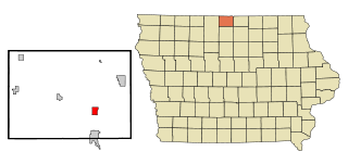
Clayton County is a county located in the U.S. state of Iowa. As of the 2020 census, the population was 17,043. Its county seat is Elkader. The county was established in 1837 and was named in honor of John M. Clayton, United States Senator from Delaware and later Secretary of State under President Zachary Taylor.

Monona, Iowa City in Iowa, United States

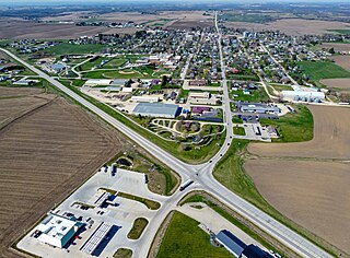
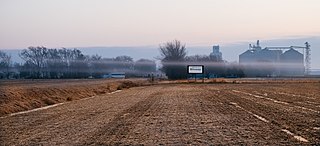
Monona is a city in Clayton County, Iowa, United States. The population was 1,471 at the time of the 2020 census.

Blencoe, Iowa City in Iowa, United States

Blencoe is a city in Monona County, Iowa, United States. The population was 233 at the 2020 census.

Moorhead, Iowa City in Iowa, United States

Moorhead is a city in Monona County, Iowa, United States. Moorhead stands along the Soldier River. The population was 199 at the time of the 2020 census.

Onawa, Iowa City in Iowa, USA

Onawa is a city in, and the county seat of, Monona County, Iowa, United States. The population was 2,906 at the time of the 2020 Census. It is the largest town on the Iowa side of the Missouri River between Council Bluffs and Sioux City.

Soldier, Iowa City in Iowa, United States

Soldier is a city in Monona County, Iowa, United States, along the Soldier River. The population was 184 at the time of the 2020 census.

Turin, Iowa City in Iowa, United States

Turin is a city in Monona County, Iowa, United States. The population was 72 at the time of the 2020 census.

Ute, Iowa City in Iowa, United States

Ute is a city in Monona County, Iowa, United States, along the Soldier River. The population was 338 at the time of the 2020 census.

Whiting, Iowa City in Iowa, United States

Whiting is a city in Monona County, Iowa, United States. The population was 745 at the time of the 2020 census.

Blue Mounds Township Township in Minnesota, United States

Blue Mounds Township is a township in Pope County, Minnesota, United States. The population was 207 at the 2000 census.

Friendship (village), Wisconsin Village in Wisconsin, United States

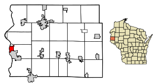
Friendship is a village in Adams County in the U.S. state of Wisconsin. It is the county seat of Adams County. The population was 725 at the 2010 census.

Blooming Grove, Wisconsin Town in Wisconsin, United States

Blooming Grove is a town in Dane County, Wisconsin, United States. The population was 1,768 at the 2000 census. The unincorporated community of Hope is located in Blooming Grove. Although once much larger, currently the town of Blooming Grove consists of a few scattered neighborhoods and individual properties broken into discontinuous sections by the cities of Madison and Monona. Blooming Grove will be dissolved and annexed into the city of Madison by 2027.

Shorewood Hills, Wisconsin Village in Wisconsin, United States

Shorewood Hills is a village in Dane County, Wisconsin, United States. It was established in 1927. The population was 2,169 at the 2020 census. Entirely surrounded by the city of Madison and Lake Mendota, it is part of the Madison Metropolitan Statistical Area.

Glendale, Wisconsin City in Wisconsin, United States

Glendale is a city in Milwaukee County, Wisconsin, United States. It is a suburb of the neighboring Milwaukee. The population was 13,357 at the 2020 census.

Wilson, Sheboygan County, Wisconsin Town in Wisconsin, United States

Wilson is a town in Sheboygan County, Wisconsin, United States. The population was 3,227 at the 2000 census. The unincorporated community of Weedens is located in the town. It is included in the Sheboygan, Wisconsin Metropolitan Statistical Area.

Stockbridge, Wisconsin Village in Wisconsin, United States

Stockbridge is a village in Calumet County, Wisconsin, United States. The population was 636 at the 2010 census. The village lies within the Town of Stockbridge.

Blue Mounds, Wisconsin Village in Wisconsin, United States

Blue Mounds is a village in Dane County, Wisconsin, United States. As of the 2010 census, the village had a population of 855. The village is adjacent to the Town of Blue Mounds, and is part of the Madison Metropolitan Statistical Area. It is the smallest incorporated community in Dane County.

Blue Mounds (town), Wisconsin Town in Wisconsin, United States

Blue Mounds is a town in Dane County, Wisconsin, United States. The population was 842 at the 2000 census. The Village of Blue Mounds is located within the town.

Cottage Grove, Wisconsin Village in Wisconsin, United States

Cottage Grove is a village in Dane County, Wisconsin, United States. The population was 6,192 at the 2010 census. A suburb of Madison, it shares a school district with Monona. The village is located within the Town of Cottage Grove.

Elk Mound is a town in Dunn County, Wisconsin, United States. The population was 1,121 at the 2000 census. The town is named after the Village of Elk Mound, located in the eastern part of the town.

References

  1. Passon, Kevin (13 April 2017). "Voters choose O'Connor as city's next mayor". The Herald-Independent. Retrieved 10 May 2017.
  2. "2019 U.S. Gazetteer Files". United States Census Bureau. Retrieved August 7, 2020.
  3. 1 2 "US Board on Geographic Names". United States Geological Survey. 2007-10-25. Retrieved 2008-01-31.
  4. 1 2 "U.S. Census website". United States Census Bureau . Retrieved 2012-11-18.
  5. 1 2 "U.S. Census website". United States Census Bureau . Retrieved 2008-01-31.
  6. 1 2 "History of Monona | Monona, WI - Official Website". mymonona.com. Retrieved 2019-03-31.
  7. The Outlet Mound (Wisconsin Historical Marker). Monona, Wisconsin: Wisconsin Historical Society. 1998.
  8. City of Monona: Parks & Recreation > Parks & Open Spaces > Indian Mounds Park
  9. LandmarkHunter.com | Outlet Mound
  10. "US Gazetteer files: 2010, 2000, and 1990". United States Census Bureau. 2011-02-12. Retrieved 2011-04-23.
  11. "US Gazetteer files 2010". United States Census Bureau. Archived from the original on 2012-01-25. Retrieved 2012-11-18.
  12. "Census of Population and Housing". Census.gov. Retrieved June 4, 2015.
  13. Monona, Wisconsin (WI 53716) profile: population, maps, real estate, averages, homes, statistics, relocation, travel, jobs, hospitals, schools, crime, moving, houses, news
  14. "The 50 best small companies to work for of 2017, according to employees".