
Volo is a village in Lake County, Illinois, United States. It was incorporated as a village on April 26, 1993. Per the 2020 census, the population was 6,122.

Poynette is a village in Columbia County, Wisconsin, United States. The population was 2,575 at the 2022 United States census. It is part of the Madison Metropolitan Statistical Area.

Bell Center is a village in Crawford County, Wisconsin, United States. The population was 117 at the 2010 census.

Neosho is a village in Dodge County, Wisconsin, United States. The population was 574 at the 2010 census.

Dickeyville is a village in Grant County, Wisconsin, United States. The population was 1,061 at the 2010 census.

Brokaw is a former village in Marathon County, Wisconsin, United States. It is part of the Wausau, Wisconsin Metropolitan Statistical Area. The population was 251 at the 2010 census. Brokaw merged with the village of Maine, Wisconsin on October 1, 2018.
Whiting is a village in Portage County, Wisconsin, United States and is a suburb of Stevens Point. It is included in the Stevens Point Micropolitan Statistical Area. The population was 1,601 at the 2020 census.

Weyerhaeuser is a village in Rusk County, Wisconsin, United States. The population was 238 at the 2010 census.
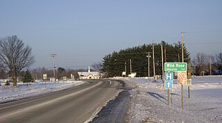
Wild Rose is a village in Waushara County, Wisconsin, United States. The population was 725 at the 2010 census.

Dorchester is a village in Clark and Marathon counties in the U.S. state of Wisconsin, along the 45th parallel. It is part of the Wausau, Wisconsin Metropolitan Statistical Area. The population was 876 at the 2010 census. Of this, 871 were in Clark County, and only 5 were in Marathon County.

Cumberland is a town in Barron County in the U.S. state of Wisconsin. The population was 818 at the 2020 census, down from 876 at the 2010 census. The City of Cumberland is located partially within the town.
Turtle Lake is a town in Barron County, Wisconsin, United States. The population was 640 at the 2020 census, up from 624 at the 2010 census. The Village of Turtle Lake is located just north of the town. The unincorporated community of Twin Town is located partially in the town.

Unity is a village in Clark and Marathon counties in the U.S. state of Wisconsin. It is part of the Wausau, Wisconsin Metropolitan Statistical Area. The population was 343 at the 2010 census. Of this, 204 were in Marathon County, and 139 were in Clark County. The village is located in northeastern town of Unity in Clark County and northwestern town of Brighton in Marathon County.

Randolph is a village in Columbia and Dodge Counties in the U.S. state of Wisconsin. The population was 1,811 at the 2010 census. Of this, 1,339 were in Dodge County, and 472 were in Columbia County. The village is located at the southeast corner of the Town of Randolph in Columbia County, although only a tiny portion of the village lies within the town. Most of the village lies within the Town of Westford in Dodge County. Small portions also lie within the Town of Fox Lake to the north and the Town of Courtland in Columbia County.

Clyman is a village in Dodge County, Wisconsin, United States. The population was 422 at the 2010 census. The village is located within the Town of Clyman.

Hazel Green is a village in Grant and Lafayette counties in the U.S. state of Wisconsin. The population was 1,256 at the 2010 census. Of this, 1,243 were in Grant County, and only 13 were in Lafayette County. The village is located mostly within the Town of Hazel Green in Grant County; only a small portion extends into the Town of Benton in Lafayette County.

Linden is a village in Iowa County, Wisconsin, United States. The population was 549 at the 2010 census. The village is located within the Town of Linden.

Casco is a village in Kewaunee County, Wisconsin, United States. The population was 583 at the 2010 census. It is part of the Green Bay Metropolitan Statistical Area. The village is located within the Town of Casco. Casco is named after Casco Bay on the coast of Maine, the previous home of Edward Decker, an early logger in Kewaunee County.

Milltown is a village in Polk County, Wisconsin, United States. The population was 917 at the 2010 census. The village is located within the Town of Milltown.

Scandinavia is a village in the Town of Scandinavia in Waupaca County, Wisconsin, United States. The population was 328 at the 2010 census.


