Edmund, Wisconsin

Last updated

Edmund, Wisconsin
Main Street, Edmund, WI.jpg
Looking down Main Street in Edmund
USA Wisconsin location map.svg
Red pog.svg
Edmund
Usa edcp location map.svg
Red pog.svg
Edmund
Coordinates: 42°58′03″N90°15′52″W / 42.96750°N 90.26444°W / 42.96750; -90.26444
Country United States
State Wisconsin
County Iowa
Town Linden
Area
  Total0.342 sq mi (0.89 km2)
  Land0.342 sq mi (0.89 km2)
  Water0 sq mi (0 km2)
Elevation
1,204 ft (367 m)
Population
 (2020)
  Total129
  Density377.2/sq mi (144.9/km2)
Time zone UTC-6 (Central (CST))
  Summer (DST) UTC-5 (CDT)
Area code 608
GNIS feature ID1564455 [1]

Edmund is a census-designated place (CDP) in the Town of Linden in Iowa County, Wisconsin, United States. [1]

Contents

Description

The CDP is located on U.S. Route 18 west of Dodgeville. The community's post office closed on November 2, 2002. [2] At the 2020 census, Edmund's population was 129. [3]

History

Edmund got its name in 1881 from Edmund V. Baker who owned the land where the settlement was located. [4]

Demographics

2020 Census

As of the 2020 census there were 129 people, 58 housing units and 80 households residing in the CDP. The population density was 377.2 inhabitants per square mile (144.9/km2). The average housing unit density was 169.6 per square mile (65.2/km2). The racial makeup of the CDP was 99.22% White, 0.00% African American, 0.00% Native American, 0.00% Asian, 0.00% Pacific Islander, 0.00% from other races, and 0.78% from two or more races. Hispanic or Latino of any race was 0.00% of the population. [3]

Of the family households, 40.0% were married couples, 22.5% were a male householder with no spouse, and 32.5% were a female householder with no spouse. The average family household had 2.36 people. [3]

The median age was 39.5, 14.5% of people were under the age of 18, and 13.3% were 65 years of age or older. Of the residents, 48.0% had German ancestry, none spoke a language other than English at home, and none were born outside the United States. [3]

The median income for a household in the CDP was $51,667, and the median income for a family was $51,578. 6.1% of the population were military veterans, and 6.6% had a batchelors degree or higher. In the CDP 18.5% of the population was below the poverty line, including 48.0% of those under age 18 and 56.5% of those age 65 or over, with 16.2% of the population without health insurance. [3]

2010 Census

At the 2010 census, Edmund's population was 173. [3]

See also

Related Research Articles

<span class="mw-page-title-main">Humboldt Hill, California</span> Census-designated place in Humboldt County, California, U.S.

Humboldt Hill is a census-designated place (CDP) in Humboldt County, California, United States. Humboldt Hill rises to an elevation of 636 feet (194 m). The population was 3,414 at the 2010 census, up from 3,246 at the 2000 census. The area is in the 95503 zip code and part of unincorporated Eureka.

<span class="mw-page-title-main">Westhaven-Moonstone, California</span> Census-designated place in California, United States

Westhaven-Moonstone is a census-designated place (CDP) located in Humboldt County, California, United States. As of the 2010 census the population was 1,205, up from 1,044 at the 2000 census.

<span class="mw-page-title-main">Keddie, California</span> Census-designated place in California, United States

Keddie is a census-designated place in Plumas County, California, United States. The population was 66 at the 2010 census.

<span class="mw-page-title-main">Cherry Grove, Ohio</span> Census-designated place in Ohio, United States

Cherry Grove is a census-designated place (CDP) in Anderson Township, Hamilton County, Ohio, United States. The population was 4,419 at the 2020 census.

<span class="mw-page-title-main">Covedale, Ohio</span> Census-designated place in Ohio, United States

Covedale is a census-designated place (CDP) in Green Township, Hamilton County, Ohio, United States. The population was 6,472 at the 2020 census. The CDP represents the part of the former village of Covedale that was not annexed by the city of Cincinnati in the 1890s.

<span class="mw-page-title-main">Dillonvale, Hamilton County, Ohio</span> Census-designated place in Ohio, United States

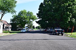
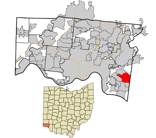
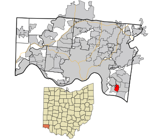
Dillonvale is a census-designated place (CDP) in Sycamore Township, Hamilton County, Ohio, United States. The population was 3,436 at the 2020 census.

<span class="mw-page-title-main">Dry Run, Ohio</span> Census-designated place in Ohio, United States

Dry Run is a census-designated place (CDP) in Hamilton County, Ohio, United States. The population was 7,672 at the 2020 census.

<span class="mw-page-title-main">Fruit Hill, Ohio</span> Census-designated place in Ohio, United States

Fruit Hill is a census-designated place (CDP) in Hamilton County, Ohio, United States. The population was 3,748 at the 2020 census.

<span class="mw-page-title-main">Pleasant Run, Ohio</span> Census-designated place in Ohio, United States

Pleasant Run is a census-designated place (CDP) in Hamilton County, Ohio, United States. The population was 4,861 at the 2020 census.

<span class="mw-page-title-main">Merrifield, Virginia</span> Census-designated place in Virginia, United States

Merrifield is a census-designated place (CDP) in Fairfax County, Virginia, United States. The population was 20,488 at the 2020 census.

<span class="mw-page-title-main">Eschbach, Washington</span> CDP in Washington, United States

Eschbach is a census-designated place (CDP) in Yakima County, Washington, United States. The population was 415 at the 2010 census.

<span class="mw-page-title-main">Helenville, Wisconsin</span> Census-designated place in Wisconsin, United States

Helenville is a census-designated place (CDP) in the town of Jefferson, Jefferson County, Wisconsin, United States. The population was 238 at the 2020 census.

<span class="mw-page-title-main">Eagle Lake, Wisconsin</span> CDP in Wisconsin, United States

Eagle Lake is a census-designated place (CDP) in the town of Dover, Racine County, Wisconsin, United States. The population was 1,251 at the 2020 census.

<span class="mw-page-title-main">Potter Lake, Wisconsin</span> CDP in Wisconsin, United States

Potter Lake is a census-designated place (CDP) in the town of East Troy, Walworth County, Wisconsin, United States. The population was 1,117 at the 2020 census.

<span class="mw-page-title-main">Embarrass, Wisconsin</span> Village in Wisconsin, United States

Embarrass is a village in Waupaca County, Wisconsin, United States. The population was 404 at the 2010 census.

<span class="mw-page-title-main">Lake Wisconsin, Wisconsin</span> CDP in Wisconsin, United States

Lake Wisconsin is a census-designated place (CDP) in Columbia and Sauk counties, in the towns of Lodi and Merrimac, in Wisconsin, United States. The population was 4,189 at the 2010 census.

<span class="mw-page-title-main">Windsor, Wisconsin</span> Village in Wisconsin, United States

Windsor is a village and former town in Dane County, Wisconsin. The population was 8,754 at the time of the 2020 census. The communities of Lake Windsor, Morrisonville, and Token Creek are located within the village. Windsor voted to incorporate as a village on November 3, 2015; prior to its incorporation, it was a town, and a portion of the town was a census-designated place. Windsor is a part of the Census Bureau's Madison metropolitan statistical area.

Penfield is an unincorporated census-designated place in Compromise Township, Champaign County, Illinois, United States. Its population was 151 at the 2020 census.

Braddock is a census-designated place in Fairfax County, Virginia, United States. It was first listed as a CDP in the 2020 census with a population of 6,549.

Difficult Run is a census designated place in Fairfax County, Virginia, United States. The population was 10,600 at the 2020 census. The CDP has a land area of 8.38 square miles.

References

  1. 1 2 U.S. Geological Survey Geographic Names Information System: Edmund
  2. "Postmaster Finder - Post Offices by ZIP Code". United States Postal Service . Retrieved September 25, 2011.
  3. 1 2 3 4 5 6 "U.S. Census website". U.S. Census Bureau . Retrieved April 3, 2011.
  4. Chicago and North Western Railway Company (1908). A History of the Origin of the Place Names Connected with the Chicago & North Western and Chicago, St. Paul, Minneapolis & Omaha Railways. p. 67.

Commons-logo.svg Media related to Edmund, Wisconsin at Wikimedia Commons