Eden, Iowa County, Wisconsin

Last updated
Eden, Wisconsin
WIMap-doton-Eden b.png
Location of Eden, Wisconsin
Coordinates: 42°58′35″N90°20′5″W / 42.97639°N 90.33472°W / 42.97639; -90.33472 Coordinates: 42°58′35″N90°20′5″W / 42.97639°N 90.33472°W / 42.97639; -90.33472
Country Flag of the United States.svg  United States
State Flag of Wisconsin.svg  Wisconsin
County Iowa
Area
  Total35.3 sq mi (91.4 km2)
  Land35.2 sq mi (91.1 km2)
  Water0.1 sq mi (0.3 km2)
Elevation
[1]
1,201 ft (366 m)
Population
 (2000)
  Total397
  Density11.3/sq mi (4.4/km2)
Time zone UTC-6 (Central (CST))
  Summer (DST) UTC-5 (CDT)
Area code 608
FIPS code 55-22525 [2]
GNIS feature ID1583131 [1]

Eden is a town in Iowa County, Wisconsin, United States. The population was 397 at the 2000 census.

Contents

Geography

According to the United States Census Bureau, the town has a total area of 35.3 square miles (91.5 km2), of which, 35.2 square miles (91.1 km2) of it is land and 0.1 square miles (0.3 km2) of it (0.34%) is water.

Demographics

As of the census [2] of 2000, there were 397 people, 135 households, and 112 families residing in the town. The population density was 11.3 people per square mile (4.4/km2). There were 147 housing units at an average density of 4.2 per square mile (1.6/km2). The racial makeup of the town was 98.24% White, 0.50% Asian, and 1.26% from other races.

There were 135 households, out of which 45.2% had children under the age of 18 living with them, 74.8% were married couples living together, 3.0% had a female householder with no husband present, and 17.0% were non-families. 13.3% of all households were made up of individuals, and 5.2% had someone living alone who was 65 years of age or older. The average household size was 2.94 and the average family size was 3.23.

In the town, the population was spread out, with 33.2% under the age of 18, 4.8% from 18 to 24, 29.7% from 25 to 44, 22.9% from 45 to 64, and 9.3% who were 65 years of age or older. The median age was 35 years. For every 100 females, there were 114.6 males. For every 100 females age 18 and over, there were 113.7 males.

The median income for a household in the town was $42,813, and the median income for a family was $48,250. Males had a median income of $24,861 versus $21,964 for females. The per capita income for the town was $18,084. About 7.5% of families and 8.8% of the population were below the poverty line, including 10.1% of those under age 18 and 5.1% of those age 65 or over.

Related Research Articles

<span class="mw-page-title-main">Carbon, Indiana</span> Town in Indiana, United States

Carbon is a town in Van Buren Township, Clay County, Indiana, United States. The population was 397 at the 2010 census. It is part of the Terre Haute Metropolitan Statistical Area.

<span class="mw-page-title-main">Pierceton, Indiana</span> Town in Indiana, United States

Pierceton is a town in Washington Township, Kosciusko County, in the U.S. state of Indiana. The population was 1,015 at the 2010 census.

<span class="mw-page-title-main">Morgantown, Indiana</span> Town in Indiana, United States

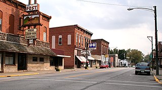
Morgantown is a town at the intersection of Indiana state routes 135 and 252 in Jackson Township, Morgan County, in the U.S. state of Indiana. The population was 986 at the 2010 census.

<span class="mw-page-title-main">Westfield, Maine</span> Town in the state of Maine, United States

Westfield is a town in Aroostook County, Maine, United States. The population was 455 at the 2020 census.

Canaan is a town in Somerset County, Maine, United States. The population was 2,193 at the 2020 census.

Embden is a town in Somerset County, Maine, United States. The population was 902 at the 2020 census.

<span class="mw-page-title-main">Pittsville, Maryland</span> Town in Maryland, United States

Pittsville is a town in Wicomico County, Maryland, United States. The population was 1,417 at the 2010 census. It is included in the Salisbury, Maryland-Delaware Metropolitan Statistical Area.

<span class="mw-page-title-main">Stratford, New Hampshire</span> Town in New Hampshire, United States

Stratford is a town located on the Connecticut River in Coös County, New Hampshire, United States. The population was 662 at the 2020 census, down from 746 at the 2010 census. Within the town are the villages of North Stratford, Stratford Hollow, and Beatties. U.S. Route 3 passes through the center of town, as does the St. Lawrence and Atlantic Railroad, formerly a part of the Grand Trunk Railway.

<span class="mw-page-title-main">Hartford, Ohio</span> Village in Ohio, United States

Hartford is a village in the township of the same name in Licking County, Ohio, United States. The population was 397 at the 2010 census.

<span class="mw-page-title-main">Lowell, Oregon</span> City in Oregon, United States

Lowell is a city in Lane County, in the U.S. state of Oregon. As of the 2010 census, the city population was 1,045. The city is on the north shore of Dexter Reservoir on the Middle Fork Willamette River. The most used route to Lowell is along Lowell Bridge, a covered bridge that crosses the reservoir from Oregon Route 58.

<span class="mw-page-title-main">Jackson Township, Lebanon County, Pennsylvania</span> Township in Pennsylvania, United States

Jackson Township is a township in Lebanon County, Pennsylvania, United States. The population was 9,352 at the 2020 census.

<span class="mw-page-title-main">Middletown Springs, Vermont</span> Town in Vermont, United States

Middletown Springs is a town in Rutland County, Vermont, United States. The population was 794 at the 2020 census.

<span class="mw-page-title-main">Danville, West Virginia</span> Town in West Virginia, United States

Danville is a town in Boone County, West Virginia, United States. The population was 660 at the 2020 census. Danville was incorporated in 1911 and named for Dan Rock, the town's first postmaster. Danville was formerly known as Newport and Red House.

<span class="mw-page-title-main">Jackson, Adams County, Wisconsin</span> Town in Wisconsin, United States

Jackson is a town in Adams County in the U.S. state of Wisconsin. The population was 1,003 at the 2010 census.

<span class="mw-page-title-main">Elba, Wisconsin</span> Town in Wisconsin, United States

Elba is a town in Dodge County, Wisconsin, United States. The population was 1,086 at the 2000 census. The unincorporated communities of Astico and Danville are located in the town.

<span class="mw-page-title-main">Forest, Fond du Lac County, Wisconsin</span> Town in Wisconsin, United States

Forest is a town in Fond du Lac County, Wisconsin, United States. The population was 1,108 at the 2000 census. The unincorporated communities of Banner, Dotyville, and Graham Corners are located in the town.

<span class="mw-page-title-main">North Bend, Wisconsin</span> Town in Wisconsin, United States

North Bend is a town in Jackson County, Wisconsin, United States. The population was 397 at the 2000 census. The unincorporated communities of Buckholz Corners and North Bend are located in the town.

<span class="mw-page-title-main">Shelby, Wisconsin</span> Town in Wisconsin, United States

Shelby is a town in La Crosse County, Wisconsin, United States. It is part of the La Crosse, Wisconsin Metropolitan Statistical Area. The population was 4,715 at the 2010 census. The unincorporated community of Shelby is located in the town.

<span class="mw-page-title-main">Sturgeon Bay (town), Wisconsin</span> Town in Wisconsin, United States

Sturgeon Bay is a town in Door County, Wisconsin, USA. The population was 865 at the 2000 census.

<span class="mw-page-title-main">Woodland, Aroostook County, Maine</span> Town in the state of Maine, United States

Woodland is a town in Aroostook County, Maine, United States. The population was 1,217 at the 2020 census. Because the state of Maine has a law stating that no two towns may share the same name, Woodland of Aroostook County and Woodland of Washington County found themselves before the Maine Supreme Judicial Court in the late 1990s. Because it was founded as a township first, Woodland of Aroostook County was allowed to keep its name and Woodland of Washington County was ordered by the court to choose a new name: Baileyville.

References

  1. 1 2 "US Board on Geographic Names". United States Geological Survey. 2007-10-25. Retrieved 2008-01-31.
  2. 1 2 "U.S. Census website". United States Census Bureau . Retrieved 2008-01-31.