Livingston, Wisconsin

Last updated
Livingston, Wisconsin
Livingston, WI library.jpg
Livingston library
Grant County Wisconsin Incorporated and Unincorporated areas Livingston Highlighted.svg
Location of Livingston in Grant County, Wisconsin.
Coordinates: 42°54′3″N90°25′54″W / 42.90083°N 90.43167°W / 42.90083; -90.43167 Coordinates: 42°54′3″N90°25′54″W / 42.90083°N 90.43167°W / 42.90083; -90.43167
Country Flag of the United States.svg  United States
State Flag of Wisconsin.svg  Wisconsin
Counties Grant, Iowa
Area
[1]
  Total1.04 sq mi (2.69 km2)
  Land1.04 sq mi (2.69 km2)
  Water0.00 sq mi (0.00 km2)
Elevation
[2]
1,152 ft (351 m)
Population
 (2010) [3]
  Total664
  Estimate 
(2019) [4]
634
  Density609.62/sq mi (235.47/km2)
Time zone UTC-6 (Central (CST))
  Summer (DST) UTC-5 (CDT)
Area code 608
FIPS code 55-45325 [5]
GNIS feature ID1568470 [2]
Website http://livingstonvillage.webs.com

Livingston is a village in Grant and Iowa Counties in the U.S. state of Wisconsin. The population was 664 at the 2010 census. Of this, 657 were in Grant County, and only 7 were in Iowa County.

Contents

The Iowa County portion of Livingston is part of the Madison Metropolitan Statistical Area, while the Grant County portion is part of the Platteville Micropolitan Statistical Area.

History

A post office called Livingston has been in operation since 1880. [6] The village was named for Hugh Livingston, the original owner of the town site. [7]

A meteorite fell to the Earth near and in the village on April 14, 2010, following a spectacular bolide and aerial explosion seen over much of the midwestern United States. [8]

Geography

Livingston is located at 42°54′3″N90°25′54″W / 42.90083°N 90.43167°W / 42.90083; -90.43167 (42.900713, -90.431649). [9]

According to the United States Census Bureau, the village has a total area of 1.02 square miles (2.64 km2), all of it land. [10]

Demographics

Historical population
CensusPop.
1880 28
1920 545
1930 470−13.8%
1940 52010.6%
1950 452−13.1%
1960 4888.0%
1970 5033.1%
1980 64227.6%
1990 576−10.3%
2000 5973.6%
2010 66411.2%
2019 (est.)634 [4] −4.5%
U.S. Decennial Census [11]

2010 census

As of the census [3] of 2010, there were 664 people, 263 households, and 175 families living in the village. The population density was 651.0 inhabitants per square mile (251.4/km2). There were 277 housing units at an average density of 271.6 per square mile (104.9/km2). The racial makeup of the village was 99.7% White, 0.2% African American, and 0.2% from two or more races.

There were 263 households, of which 33.1% had children under the age of 18 living with them, 54.8% were married couples living together, 6.5% had a female householder with no husband present, 5.3% had a male householder with no wife present, and 33.5% were non-families. 28.5% of all households were made up of individuals, and 17.5% had someone living alone who was 65 years of age or older. The average household size was 2.50 and the average family size was 3.05.

The median age in the village was 35.8 years. 27.3% of residents were under the age of 18; 6.2% were between the ages of 18 and 24; 26.5% were from 25 to 44; 22.5% were from 45 to 64; and 17.5% were 65 years of age or older. The gender makeup of the village was 48.5% male and 51.5% female.

2000 census

As of the census [5] of 2000, there were 597 people, 252 households, and 161 families living in the village. The population density was 581.5 people per square mile (223.8/km2). There were 262 housing units at an average density of 255.2 per square mile (98.2/km2). The racial makeup of the village was 100.00% White. Hispanic or Latino of any race were 0.34% of the population.

There were 252 households, out of which 27.8% had children under the age of 18 living with them, 53.6% were married couples living together, 7.1% had a female householder with no husband present, and 36.1% were non-families. 32.9% of all households were made up of individuals, and 17.5% had someone living alone who was 65 years of age or older. The average household size was 2.37 and the average family size was 3.02.

In the village, the population was spread out, with 23.1% under the age of 18, 7.9% from 18 to 24, 28.8% from 25 to 44, 22.6% from 45 to 64, and 17.6% who were 65 years of age or older. The median age was 40 years. For every 100 females, there were 91.3 males. For every 100 females age 18 and over, there were 87.3 males.

The median income for a household in the village was $35,417, and the median income for a family was $41,477. Males had a median income of $26,875 versus $19,265 for females. The per capita income for the village was $16,647. About 2.5% of families and 5.4% of the population were below the poverty line, including 2.6% of those under age 18 and 11.3% of those age 65 or over.

Notable people

Related Research Articles

<span class="mw-page-title-main">Paulden, Arizona</span> CDP in Yavapai County, Arizona

Paulden is a census designated place (CDP) in Yavapai County, Arizona, United States. The population was 5,231 at the 2010 census.

<span class="mw-page-title-main">Livingston, Illinois</span> Village in Illinois, United States

Livingston is a village in Madison County, Illinois, United States. The population was 858 at the 2010 census.

Gloria Glens Park, Ohio Village in Ohio, United States

Gloria Glens Park is a village in Medina County, Ohio, United States. The population was 425 at the 2010 census.

<span class="mw-page-title-main">Doylestown, Wisconsin</span> Village in Wisconsin, United States

Doylestown is a village in Columbia County, Wisconsin, United States. The population was 297 at the 2010 census. It is part of the Madison Metropolitan Statistical Area.

<span class="mw-page-title-main">Kekoskee, Wisconsin</span> Village in Wisconsin, United States

Kekoskee is a village in Dodge County, Wisconsin, United States. The population was 161 at the 2010 census.

<span class="mw-page-title-main">Neosho, Wisconsin</span> Village in Wisconsin, United States

Neosho is a village in Dodge County, Wisconsin, United States. The population was 574 at the 2010 census.

<span class="mw-page-title-main">Taylor, Wisconsin</span> Village in Wisconsin, United States

Taylor is a village in Jackson County, Wisconsin, United States, along the Trempealeau River. The population was 476 at the 2010 census.

<span class="mw-page-title-main">South Wayne, Wisconsin</span> Village in Wisconsin, United States

South Wayne is a village in Lafayette County, Wisconsin, United States. The population was 489 at the 2010 census.

<span class="mw-page-title-main">Ingram, Wisconsin</span> Village in Wisconsin, United States

Ingram is a village in Rusk County, Wisconsin, United States. The population was 78 at the 2010 census.

<span class="mw-page-title-main">La Farge, Wisconsin</span> Village in Wisconsin, United States

La Farge is a village along the Kickapoo River in Vernon County, Wisconsin, United States. The population was 746 at the 2010 census.

Biron, Wisconsin Village in Wisconsin, United States

Biron is a village in Wood County, Wisconsin, United States. The population was 839 at the 2010 census. It is the site of Catalyst Paper's Biron Mill.

<span class="mw-page-title-main">De Soto, Wisconsin</span> Village in Wisconsin, United States

De Soto is a village mostly in Vernon County but also in Crawford County in Wisconsin. The population was 287 at the 2010 census. Of this, 179 were in living in Vernon County, and 108 were living in Crawford County. The downtown and business area is located in Crawford County.

<span class="mw-page-title-main">Montfort, Wisconsin</span> Village in Wisconsin, United States

Montfort is a village in Grant and Iowa Counties in the U.S. state of Wisconsin. The population was 718 at the 2010 census. Of this, 622 were in Grant County, and 96 were in Iowa County.

Burke is a village in Franklin County, New York, United States. The population was 211 at the 2010 census. The village is in the town of Burke and is northeast of Malone, the county seat.

Leicester is a village in the town of Leicester, Livingston County, New York, United States. The population was 468 at the 2010 census, out of 2,200 in the entire town of Leicester. The village and town are named after Leicester Phelps, an early inhabitant.

<span class="mw-page-title-main">Unity, Wisconsin</span> Village in Wisconsin, United States

Unity is a village in Clark and Marathon counties in the U.S. state of Wisconsin. It is part of the Wausau, Wisconsin Metropolitan Statistical Area. The population was 343 at the 2010 census. Of this, 204 were in Marathon County, and 139 were in Clark County. The village is located in northeastern town of Unity in Clark County and northwestern town of Brighton in Marathon County.

<span class="mw-page-title-main">Wyocena, Wisconsin</span> Village in Wisconsin, United States

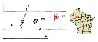
Wyocena is a village in Columbia County, Wisconsin, United States. The population was 768 at the 2010 census. The village is located within the Town of Wyocena. It is part of the Madison Metropolitan Statistical Area.

<span class="mw-page-title-main">Eden, Wisconsin</span> Village in Wisconsin, United States

Eden is a village in Fond du Lac County, Wisconsin, United States. The population was 875 at the 2010 census. The village is located within the Town of Eden.

<span class="mw-page-title-main">Mount Hope, Wisconsin</span> Village in Wisconsin, United States

Mount Hope is a village in Grant County, Wisconsin, United States. The population was 225 at the 2010 census. The village is located within the Town of Mount Hope.

<span class="mw-page-title-main">Elderon, Wisconsin</span> Village in Wisconsin, United States

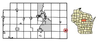
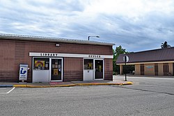
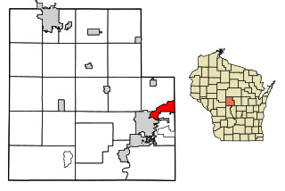
Elderon is a village in Marathon County, Wisconsin, United States. It is part of the Wausau, Wisconsin Metropolitan Statistical Area. The population was 179 at the 2010 census.

References

  1. "2019 U.S. Gazetteer Files". United States Census Bureau. Retrieved August 7, 2020.
  2. 1 2 "US Board on Geographic Names". United States Geological Survey. 2007-10-25. Retrieved 2008-01-31.
  3. 1 2 "U.S. Census website". United States Census Bureau . Retrieved 2012-11-18.
  4. 1 2 "Population and Housing Unit Estimates". United States Census Bureau. May 24, 2020. Retrieved May 27, 2020.
  5. 1 2 "U.S. Census website". United States Census Bureau . Retrieved 2008-01-31.
  6. "Grant County". Jim Forte Postal History. Retrieved 22 March 2015.
  7. Chicago and North Western Railway Company (1908). A History of the Origin of the Place Names Connected with the Chicago & North Western and Chicago, St. Paul, Minneapolis & Omaha Railways. p. 95.
  8. Ron Seely (2010-04-16). "Meteorite found in southwestern Wisconsin". Wisconsin State Journal . Retrieved 2010-04-17.
  9. "US Gazetteer files: 2010, 2000, and 1990". United States Census Bureau. 2011-02-12. Retrieved 2011-04-23.
  10. "US Gazetteer files 2010". United States Census Bureau. Archived from the original on 2012-07-02. Retrieved 2012-11-18.
  11. "Census of Population and Housing". Census.gov. Retrieved June 4, 2015.
  12. 'Wisconsin Blue Book 1954, Biographical Sketch of William A. Loy, pg. 44