Bloomington, Wisconsin

Last updated

Bloomington
Downtown Bloomington, Wisconsin.jpg
Downtown Bloomington on WIS 35
Grant County Wisconsin Incorporated and Unincorporated areas Bloomington Highlighted.svg
Location of Bloomington in Grant County, Wisconsin.
Coordinates: 42°53′31.95″N90°55′38.45″W / 42.8922083°N 90.9273472°W / 42.8922083; -90.9273472
CountryUnited States
State Wisconsin
County Grant
Area
[1]
  Total1.26 sq mi (3.27 km2)
  Land1.26 sq mi (3.27 km2)
  Water0.00 sq mi (0.00 km2)
Elevation
[2]
1,040 ft (317 m)
Population
 (2010) [3]
  Total735
  Estimate 
(2019) [4]
696
  Density551.51/sq mi (212.95/km2)
Time zone UTC-6 (Central (CST))
  Summer (DST) UTC-5 (CDT)
Area code 608
FIPS code 55-08400 [5]
GNIS feature ID1582835 [2]

Bloomington is a village in Grant County, Wisconsin, United States. The population was 735 as of the 2010 census. The village is located within the Town of Bloomington.

Contents

Geography

Bloomington is located at 42°53′31.95″N90°55′38.45″W / 42.8922083°N 90.9273472°W / 42.8922083; -90.9273472 . [6]

According to the United States Census Bureau, the village has a total area of 1.28 square miles (3.32 km2), all of it land. [7]

Demographics

Historical population
CensusPop.Note
1870 365
1880 40310.4%
1890 58745.7%
1900 6114.1%
1910 6201.5%
1920 6576.0%
1930 591−10.0%
1940 67714.6%
1950 631−6.8%
1960 73516.5%
1970 719−2.2%
1980 7433.3%
1990 7764.4%
2000 701−9.7%
2010 7354.9%
2019 (est.)696 [4] −5.3%
U.S. Decennial Census [8]

2010 census

As of the census [3] of 2010, there were 735 people, 320 households, and 208 families living in the village. The population density was 574.2 inhabitants per square mile (221.7/km2). There were 338 housing units at an average density of 264.1 per square mile (102.0/km2). The racial makeup of the village was 98.2% White, 0.1% African American, 0.1% Native American, 0.3% Asian, 0.3% from other races, and 1.0% from two or more races. Hispanic or Latino of any race were 1.1% of the population.

There were 320 households, of which 29.1% had children under the age of 18 living with them, 53.1% were married couples living together, 7.2% had a female householder with no husband present, 4.7% had a male householder with no wife present, and 35.0% were non-families. 30.9% of all households were made up of individuals, and 17.2% had someone living alone who was 65 years of age or older. The average household size was 2.30 and the average family size was 2.86.

The median age in the village was 40.7 years. 25% of residents were under the age of 18; 6.3% were between the ages of 18 and 24; 23.5% were from 25 to 44; 24% were from 45 to 64; and 21.4% were 65 years of age or older. The gender makeup of the village was 49.4% male and 50.6% female.

2000 census

As of the census [5] of 2000, there were 701 people, 308 households, and 198 families living in the village. The population density was 541.2 people per square mile (208.2/km2). There were 329 housing units at an average density of 254.0 per square mile (97.7/km2). The racial makeup of the village was 99.71% White, 0.14% Native American, and 0.14% from two or more races. 0.00% of the population were Hispanic or Latino of any race.

There were 308 households, out of which 25.6% had children under the age of 18 living with them, 55.5% were married couples living together, 4.2% had a female householder with no husband present, and 35.4% were non-families. 31.2% of all households were made up of individuals, and 18.5% had someone living alone who was 65 years of age or older. The average household size was 2.28 and the average family size was 2.84.

In the village, the population was spread out, with 23.4% under the age of 18, 6.8% from 18 to 24, 24.8% from 25 to 44, 23.3% from 45 to 64, and 21.7% who were 65 years of age or older. The median age was 42 years. For every 100 females, there were 94.7 males. For every 100 females age 18 and over, there were 95.3 males.

The median income for a household in the village was $34,750, and the median income for a family was $40,833. Males had a median income of $26,953 versus $17,917 for females. The per capita income for the village was $17,960. About 2.8% of families and 4.6% of the population were below the poverty line, including 2.9% of those under age 18 and 10.2% of those age 65 or over.

Related Research Articles

<span class="mw-page-title-main">Bloomington, California</span> Place in California, United States

Bloomington is an unincorporated community in San Bernardino County, California, United States. The population was 23,851 at the 2010 census, up from 19,318 at the 2000 census. For statistical purposes, the United States Census Bureau has defined Bloomington as a census-designated place (CDP).

<span class="mw-page-title-main">Bloomington, Idaho</span> City in Idaho, United States

Bloomington is a city in Bear Lake County, Idaho, United States. The population was 206 at the 2010 census. It was first settled in 1864.

<span class="mw-page-title-main">Mackenzie, Missouri</span> Village in Missouri, United States

Mackenzie is an unincorporated community in St. Louis County, Missouri, United States. The population was 134 at the 2010 census.

<span class="mw-page-title-main">Norwood Court, Missouri</span> Village in Missouri, United States

Norwood Court is a village in St. Louis County, Missouri, United States. The population was 959 at the 2010 census.

<span class="mw-page-title-main">Pasadena Park, Missouri</span> Village in Missouri, United States

Pasadena Park is a village in St. Louis County, Missouri, United States. The population was 470 at the 2010 census. It is part of the Normandy School District, and is distinct from the city of Pasadena Hills.

<span class="mw-page-title-main">Westwood, Missouri</span> Village in Missouri, United States

Westwood is a village in west St. Louis County, Missouri, United States. The population was 316 at the 2020 census.

<span class="mw-page-title-main">Bloomington, Nebraska</span> Village in Franklin County, Nebraska, United States

Bloomington is a village in Franklin County, Nebraska, United States. The population was 103 at the 2010 census.

<span class="mw-page-title-main">Uplands Park, Missouri</span> Village in Missouri, United States

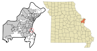
Uplands Park is a village in St. Louis County, Missouri, United States. The population was 445 at the 2010 census. The village is one of many small majority black communities located in the Natural Bridge corridor of mid-St. Louis County, characterized by small homes on small lots.

<span class="mw-page-title-main">Brice, Ohio</span> Village in Ohio, United States

Brice is a village in Franklin County, Ohio, United States, on the southeast side of the Columbus metropolitan area. The population was 93 at the 2020 census.

<span class="mw-page-title-main">New Bloomington, Ohio</span> Village in Ohio, United States

New Bloomington is a village in Marion County, Ohio, United States. The population was 413 at the 2020 census. New Bloomington is served by Elgin Local School District.

<span class="mw-page-title-main">Limaville, Ohio</span> Census-designated place in Ohio, United States

Limaville is a census-designated place (CDP) and former village in Stark County, Ohio, United States. The population was 151 at the 2010 census. It is part of the Canton–Massillon Metropolitan Statistical Area.

<span class="mw-page-title-main">Bolivar, Ohio</span> Village in Ohio, United States

Bolivar is a village in Tuscarawas County, Ohio, United States. The population was 994 at the 2010 census. Bolivar is also home to Fort Laurens, the only American Revolutionary War-era fort in what is now Ohio.

<span class="mw-page-title-main">Newcomerstown, Ohio</span> Village in Ohio, United States

Newcomerstown is a village in Tuscarawas County, Ohio, United States, 85 miles (137 km) east-northeast of Columbus. In the late 1770s, this was the largest Delaware Indian village on the Tuscarawas River, with 700 residents. Chief Newcomer (Netawatwes) was the leader of the western Delawares here, and they called the village Gekelmukpechunk. Early French traders and English settlers named the village Newcomerstown after the chief. Soon after the start of the American Revolutionary War, the Delawares moved west to Coshocton, about halfway through what is now the next county.

<span class="mw-page-title-main">Clearview, West Virginia</span> Village in West Virginia, United States

Clearview is a village in Ohio County, West Virginia, United States. It is part of the Wheeling, West Virginia Metropolitan Statistical Area. The population was 565 at the 2010 census.

<span class="mw-page-title-main">Bellevue, Wisconsin</span> Village in Wisconsin, United States

Bellevue is a village in Brown County, Wisconsin. It was a town until incorporating as a village on February 14, 2003. The population was 14,570 at the time of the 2010 census. Bellevue is part of the Green Bay metropolitan area. Bellevue sits around 4.34 miles (6.99km) east from central Green Bay.

<span class="mw-page-title-main">Kekoskee, Wisconsin</span> Village in Wisconsin, United States

Kekoskee is a village in Dodge County, Wisconsin, United States. The population was 161 at the 2010 census.

<span class="mw-page-title-main">Browntown, Wisconsin</span> Village in Wisconsin, United States

Browntown is a village in Green County, Wisconsin, United States. The population was 280 at the 2010 census.

<span class="mw-page-title-main">South Wayne, Wisconsin</span> Village in Wisconsin, United States

South Wayne is a village in Lafayette County, Wisconsin, United States. The population was 489 at the 2010 census.

<span class="mw-page-title-main">Big Falls, Waupaca County, Wisconsin</span> Village in Wisconsin, United States

Big Falls is a village in Waupaca County, Wisconsin, United States. The population was 61 at the 2010 census.

Bloomington is a town in Grant County, Wisconsin, United States. The population was 399 at the 2000 census. The Village of Bloomington is located within the town.

References

  1. "2019 U.S. Gazetteer Files". United States Census Bureau. Retrieved August 7, 2020.
  2. 1 2 "US Board on Geographic Names". United States Geological Survey. October 25, 2007. Retrieved January 31, 2008.
  3. 1 2 "U.S. Census website". United States Census Bureau . Retrieved November 18, 2012.
  4. 1 2 "Population and Housing Unit Estimates". United States Census Bureau. May 24, 2020. Retrieved May 27, 2020.
  5. 1 2 "U.S. Census website". United States Census Bureau . Retrieved January 31, 2008.
  6. "US Gazetteer files: 2010, 2000, and 1990". United States Census Bureau. February 12, 2011. Retrieved April 23, 2011.
  7. "US Gazetteer files 2010". United States Census Bureau. Archived from the original on January 25, 2012. Retrieved November 18, 2012.
  8. "Census of Population and Housing". Census.gov. Retrieved June 4, 2015.