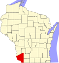
Castle Rock, Wisconsin

Last updated

Castle Rock, Wisconsin
WIMap-doton-Castle Rock.png
Location of Castle Rock, Wisconsin
Coordinates: 43°4′24″N90°29′47″W / 43.07333°N 90.49639°W / 43.07333; -90.49639
Country Flag of the United States.svg  United States
State Flag of Wisconsin.svg  Wisconsin
County Grant
Area
  Total35.8 sq mi (92.7 km2)
  Land35.8 sq mi (92.7 km2)
  Water0.0 sq mi (0.0 km2)
Elevation
[1]
728 ft (222 m)
Population
 (2000)
  Total314
  Density8.8/sq mi (3.4/km2)
Time zone UTC-6 (Central (CST))
  Summer (DST) UTC-5 (CDT)
Area code 608
FIPS code 55-13100 [2]
GNIS feature ID1582929 [1]

Castle Rock is a town in Grant County, Wisconsin, United States. The population was 314 at the 2000 census. The unincorporated community of Castle Rock is located in the town.

Contents

Geography

According to the United States Census Bureau, the town has a total area of 35.8 square miles (92.7 km2), all of it land.

Demographics

At the 2000 census there were 314 people, 112 households, and 86 families living in the town. The population density was 8.8 people per square mile (3.4/km2). There were 122 housing units at an average density of 3.4 per square mile (1.3/km2). The racial makeup of the town was 97.77% White, 0.32% Native American, 0.32% from other races, and 1.59% from two or more races. Hispanic or Latino of any race were 0.64%. [2]

Of the 112 households 36.6% had children under the age of 18 living with them, 66.1% were married couples living together, 4.5% had a female householder with no husband present, and 23.2% were non-families. 17.9% of households were one person and 5.4% were one person aged 65 or older. The average household size was 2.80 and the average family size was 3.14.

The age distribution was 25.8% under the age of 18, 6.1% from 18 to 24, 27.7% from 25 to 44, 25.8% from 45 to 64, and 14.6% 65 or older. The median age was 40 years. For every 100 females, there were 97.5 males. For every 100 females age 18 and over, there were 108.0 males.

The median household income was $40,000 and the median family income was $44,286. Males had a median income of $18,750 versus $19,792 for females. The per capita income for the town was $16,201. About 2.2% of families and 3.0% of the population were below the poverty line, including none of those under age 18 and 8.5% of those age 65 or over.

Related Research Articles

<span class="mw-page-title-main">Crystal, Maine</span> Town in the state of Maine, United States

Crystal is a town in Aroostook County, Maine, United States. The population was 248 at the 2020 census.

<span class="mw-page-title-main">Stockholm, Maine</span> Town in the state of Maine, United States

Stockholm is a town in Aroostook County, Maine, United States. The population was 250 at the 2020 census.

<span class="mw-page-title-main">Wade, Maine</span> Town in the state of Maine, United States

Wade is a town in Aroostook County, Maine, United States. The population was 229 at the 2020 census.

<span class="mw-page-title-main">Weston, Maine</span> Town in the state of Maine, United States

Weston is a town in Aroostook County, Maine, United States. The population was 245 at the 2020 census.

<span class="mw-page-title-main">Hartford, Maine</span> Town in the state of Maine, United States

Hartford is a town in Oxford County, Maine, United States. Hartford is included in the Lewiston-Auburn, Maine metropolitan New England City and Town Area. The population was 1,203 at the 2020 census.

<span class="mw-page-title-main">Smithfield, Maine</span> Town in the state of Maine, United States

Smithfield is a town in Somerset County, Maine, United States. The population was 925 at the 2020 census. The town was incorporated on February 29, 1840, making it the only town in Maine incorporated on Leap Day. The town was named after the Rev. Henry Smith, an early settler.

Northfield is a town in Washington County, Maine, United States. The population was 178 at the 2020 census.

Foster Township is a township in Faribault County, Minnesota, United States. The population was 314 at the 2000 census.

<span class="mw-page-title-main">Hanover, Ohio</span> Village in Ohio, United States

Hanover is a village in Licking County, Ohio, United States. The population was 1,270 at the 2020 census. The village lies along Ohio State Route 16.

<span class="mw-page-title-main">Foyil, Oklahoma</span> Town in Oklahoma, United States

Foyil is a town in Rogers County, Oklahoma, United States. It was named for Alfred Foyil, a local landowner and the first postmaster of the town. The population was 344 at the 2010 census, a 47.0 percent increase over the figure of 234 recorded in 2000.

<span class="mw-page-title-main">Butte Falls, Oregon</span> City in Oregon, United States

Butte Falls is a city in Jackson County, Oregon, United States. The population was 423 at the 2010 census. As of July 1, 2018, the city's population was estimated to be 450.

<span class="mw-page-title-main">Poynor, Texas</span> Town in United States

Poynor is a town in Henderson County, Texas, United States. The population was 305 at the 2010 census.

<span class="mw-page-title-main">Cairo, West Virginia</span> Town in West Virginia, United States

Cairo is a town in Ritchie County, West Virginia, United States, along West Virginia Route 31, the North Fork of the Hughes River, and the North Bend Rail Trail. The population was 174 at the 2020 census.

<span class="mw-page-title-main">Clinton, Barron County, Wisconsin</span> Town in Wisconsin, United States

Clinton is a town in Barron County, in the U.S. state of Wisconsin. The population was 879 at the 2010 census. The unincorporated community of Poskin is located in Clinton, along U.S. Route 8.

<span class="mw-page-title-main">Hewett, Wisconsin</span> Town in Wisconsin, United States

Hewett is a town in Clark County in the U.S. state of Wisconsin. The population was 314 at the 2000 census. The unincorporated community of Columbia is located in the town.

<span class="mw-page-title-main">Little Rice, Wisconsin</span> Town in Wisconsin, United States

Little Rice is a town in Oneida County, Wisconsin, United States. The population was 314 at the 2000 census. The unincorporated community of McCord is located in the town.

<span class="mw-page-title-main">Stubbs, Wisconsin</span> Town in Wisconsin, United States

Stubbs is a town in Rusk County, Wisconsin, United States. The population was 587 at the 2000 census. The unincorporated community of Apollonia is located in the town.

<span class="mw-page-title-main">Jefferson, Vernon County, Wisconsin</span> Town in Wisconsin, United States

Jefferson is a town in Vernon County, Wisconsin, United States. The population was 974 at the 2000 census. The unincorporated communities of Bud, Esofea, and Springville are located with the town.

Cassville is a town in Grant County, Wisconsin, United States. The population was 487 at the 2000 census. The Village of Cassville is located within the town.

Hammond is a town in St. Croix County, Wisconsin, United States. The population was 947 at the 2000 census. The Village of Hammond is located within the town.

References

  1. 1 2 "US Board on Geographic Names". United States Geological Survey. October 25, 2007. Retrieved January 31, 2008.
  2. 1 2 "U.S. Census website". United States Census Bureau . Retrieved January 31, 2008.