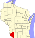
South Lancaster, Wisconsin

Last updated

South Lancaster, Wisconsin
South Lancaster Town Hall.jpg
Town hall
WIMap-doton-South Lancaster.png
Location of South Lancaster, Wisconsin
Coordinates: 42°48′24″N90°44′0″W / 42.80667°N 90.73333°W / 42.80667; -90.73333
Country Flag of the United States.svg  United States
State Flag of Wisconsin.svg  Wisconsin
County Grant
Area
  Total34.0 sq mi (88.0 km2)
  Land34.0 sq mi (88.0 km2)
  Water0.0 sq mi (0.0 km2)
Elevation
[1]
958 ft (292 m)
Population
 (2000)
  Total808
  Density23.8/sq mi (9.2/km2)
Time zone UTC-6 (Central (CST))
  Summer (DST) UTC-5 (CDT)
Area code 608
FIPS code 55-75075 [2]
GNIS feature ID1584178 [1]

South Lancaster is a town in Grant County, Wisconsin, United States. The population was 808 at the 2000 census.

Contents

Geography

According to the United States Census Bureau, the town has a total area of 34.0 square miles (88.0 km2), all of it land.

Demographics

As of the 2000 census, [2] there were 808 people, 234 households, and 179 families living in the town. The population density was 23.8 people per square mile (9.2/km2). There were 245 housing units at an average density of 7.2 per square mile (2.8/km2). The racial makeup of the town was 99.63% White, 0.25% Asian, and 0.12% from two or more races.

Of the 234 households 36.8% had children under the age of 18 living with them, 66.7% were married couples living together, 4.7% had a female householder with no husband present, and 23.1% were non-families. 14.5% of households were one person and 5.1% were one person aged 65 or older. The average household size was 2.84 and the average family size was 3.17.

The age distribution was 23.5% under the age of 18, 8.3% from 18 to 24, 24.5% from 25 to 44, 24.4% from 45 to 64, and 19.3% 65 or older. The median age was 41 years. For every 100 females, there were 102.5 males. For every 100 females age 18 and over, there were 100.6 males.

The median household income was $36,250 and the median family income was $38,333. Males had a median income of $26,917 versus $19,432 for females. The per capita income for the town was $18,698. About 1.1% of families and 5.0% of the population were below the poverty line, including 3.3% of those under age 18 and 3.0% of those age 65 or over.

Related Research Articles

<span class="mw-page-title-main">Chesterfield, Indiana</span> Town in Indiana, United States

Chesterfield is a town in the U.S. state of Indiana which lies in Union Township, Madison County, and Salem Township, Delaware County. The population was 2,490 at the 2020 census. It is part of the Indianapolis–Carmel–Anderson metropolitan statistical area.

<span class="mw-page-title-main">Etna Green, Indiana</span> Town in Indiana, United States

Etna Green is a town in Etna Township, Kosciusko County, in the U.S. state of Indiana. The population was 586 at the 2010 census.

<span class="mw-page-title-main">Woodlawn Heights, Indiana</span> Town in Indiana, United States

Woodlawn Heights is a town in Anderson Township, Madison County, Indiana, United States. It is part of the Indianapolis–Carmel–Anderson metropolitan statistical area. The population was 91 at the 2020 census.

<span class="mw-page-title-main">Weldon, Iowa</span> City in Iowa, United States

Weldon is a city in Clarke and Decatur counties of the U.S. state of Iowa. The population was 136 at the time of the 2020 census.

<span class="mw-page-title-main">Blaine, Maine</span> Town in the state of Maine, United States

Blaine is a town in Aroostook County, Maine, United States. The population was 667 at the 2020 census. It was known as Alva prior to incorporation in 1874, when it was renamed in honor of James G. Blaine, then Speaker of the U.S. House of Representatives. According to the Blaine 1974 Centennial Celebration Pamphlet, the town's namesake donated a schoolhouse bell in return for the town changing its name. The bell, cast in 1875 by William Blake & Co., now resides in the former Blaine Grange Hall and is under the care of the Central Aroostook Historical Society.

<span class="mw-page-title-main">St. Francis, Maine</span> Town in the state of Maine, United States

St. Francis is a town in Aroostook County, Maine, United States on the Canada–United States border at the junction of the St. Francis River and the Saint John River. The population was 438 at the 2020 census. First settled by English speakers from southern Maine, the original population has been supplanted by French-speaking Acadians.

Lowell is a town in Penobscot County, Maine, United States. The population was 368 at the 2020 census.

<span class="mw-page-title-main">Secretary, Maryland</span> Town in Maryland, United States

Secretary is a town in Dorchester County, Maryland, United States. The population was 535 at the 2010 census.

Center Township is a township in Crow Wing County, Minnesota, United States. The population was 808 at the 2000 census.

<span class="mw-page-title-main">Diamond, Missouri</span> City in Missouri, United States

Diamond is a city in north central Newton County, Missouri, United States, located southeast of Joplin. The population was 831 at the 2020 census. It is part of the Joplin, Missouri, Metropolitan Statistical Area. Diamond is primarily renowned as the birthplace of George Washington Carver.

<span class="mw-page-title-main">Metamora, Ohio</span> Village in Ohio, United States

Metamora is a village in Fulton County, Ohio, United States. The population was 566 at the 2020 census.

<span class="mw-page-title-main">Plymouth, Utah</span> Town in Utah, United States

Plymouth is a town in Box Elder County, Utah, United States. The population was 414 at the 2010 census.

<span class="mw-page-title-main">Belmont, West Virginia</span> Town in West Virginia, United States

Belmont is a town in Pleasants County, West Virginia, United States. It is part of the Parkersburg–Vienna metropolitan area. The population was 872 at the 2020 census. Belmont was incorporated on April 19, 1946, by the Circuit Court of Pleasants County. The city was named for the beautiful hills in the area.

<span class="mw-page-title-main">Rhodell, West Virginia</span> Unincorporated community in West Virginia, United States

Rhodell is an unincorporated community in Raleigh County, West Virginia, United States. The population was 173 at the 2010 census.

<span class="mw-page-title-main">Waterloo, Grant County, Wisconsin</span> Town in Wisconsin, United States

Waterloo is a town in Grant County in the U.S. state of Wisconsin. The population was 557 at the 2000 census. The unincorporated communities of Burton and McCartney are located in the town.

<span class="mw-page-title-main">Hartland, Shawano County, Wisconsin</span> Town in Wisconsin, United States

Hartland is a town in Shawano County, Wisconsin, United States. The population was 825 at the 2000 census. The unincorporated community of Slab City is located within the town. The unincorporated communities of Frazer Corners and Zachow are also located partially in the town. Hartland was established in 1859.

<span class="mw-page-title-main">Erin Prairie, Wisconsin</span> Town in Wisconsin, United States

Erin Prairie is a town in St. Croix County, Wisconsin, United States. The population was 658 at the 2000 census. The unincorporated communities of Erin Corner and Jewitt are located in the town.

<span class="mw-page-title-main">Springfield, St. Croix County, Wisconsin</span> Town in Wisconsin, United States

Springfield is a town in St. Croix County, Wisconsin, United States. The population was 808 at the 2000 census. The unincorporated community of Hersey is located in the town.

<span class="mw-page-title-main">Sterling, Vernon County, Wisconsin</span> Town in Wisconsin, United States

Sterling is a town in Vernon County, Wisconsin, United States. The population was 713 at the 2000 census. The unincorporated communities of Purdy, Retreat, and West Prairie are located in the town.

<span class="mw-page-title-main">Bear Creek, Waupaca County, Wisconsin</span> Town in Wisconsin, United States

Bear Creek is a town in Waupaca County, Wisconsin, United States. The population was 838 at the 2000 census. The unincorporated communities of Bear Creek Corners and Nicholson are located in the town. The village of Bear Creek is located immediately east of the town, across the county line in Outagamie County.

References

  1. 1 2 "US Board on Geographic Names". United States Geological Survey. October 25, 2007. Retrieved January 31, 2008.
  2. 1 2 "U.S. Census website". United States Census Bureau . Retrieved January 31, 2008.