Tennyson, Wisconsin

Last updated
Tennyson, Wisconsin
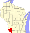
Grant County Wisconsin Incorporated and Unincorporated areas Tennyson Highlighted.svg
Location of Tennyson in Grant County, Wisconsin.
Coordinates: 42°41′16″N90°41′10″W / 42.68778°N 90.68611°W / 42.68778; -90.68611 Coordinates: 42°41′16″N90°41′10″W / 42.68778°N 90.68611°W / 42.68778; -90.68611
Country United States
State Wisconsin
County Grant
Area
[1]
  Total0.43 sq mi (1.12 km2)
  Land0.43 sq mi (1.12 km2)
  Water0.00 sq mi (0.00 km2)
Elevation
[2]
932 ft (284 m)
Population
 (2010) [3]
  Total355
  Estimate 
(2019) [4]
342
  Density793.50/sq mi (306.34/km2)
Time zone UTC-6 (Central (CST))
  Summer (DST) UTC-5 (CDT)
Area code(s) 608
FIPS code 55-79250 [5]
GNIS feature ID1575312 [2]

Tennyson is a village in Grant County, Wisconsin, United States, originally called Dutch Hollow. [6] The population was 355 at the 2010 census.

Contents

Geography

Tennyson is located at 42°41′16″N90°41′10″W / 42.68778°N 90.68611°W / 42.68778; -90.68611 (42.687731, -90.685990). [7]

According to the United States Census Bureau, the village has a total area of 0.42 square miles (1.09 km2), all of it land. [8]

Demographics

Historical population
CensusPop.
1950 211
1960 31448.8%
1970 40228.0%
1980 47618.4%
1990 378−20.6%
2000 370−2.1%
2010 355−4.1%
Est. 2019342 [4] −3.7%
U.S. Decennial Census [9]

2010 census

As of the census [3] of 2010, there were 355 people, 144 households, and 102 families living in the village. The population density was 845.2 inhabitants per square mile (326.3/km2). There were 148 housing units at an average density of 352.4 per square mile (136.1/km2). The racial makeup of the village was 99.4% White and 0.6% Native American.

There were 144 households of which 33.3% had children under the age of 18 living with them, 54.9% were married couples living together, 13.2% had a female householder with no husband present, 2.8% had a male householder with no wife present, and 29.2% were non-families. 24.3% of all households were made up of individuals and 17.4% had someone living alone who was 65 years of age or older. The average household size was 2.47 and the average family size was 2.90.

The median age in the village was 44.3 years. 23.7% of residents were under the age of 18; 9% were between the ages of 18 and 24; 17.7% were from 25 to 44; 28% were from 45 to 64; and 21.7% were 65 years of age or older. The gender makeup of the village was 51.8% male and 48.2% female.

2000 census

As of the census [5] of 2000, there were 370 people, 139 households, and 102 families living in the village. The population density was 878.7 people per square mile (340.1/km²). There were 143 housing units at an average density of 339.6 per square mile (131.5/km²). The racial makeup of the village was 100.00% White. Hispanic or Latino of any race were 0.54% of the population.

There were 139 households out of which 31.7% had children under the age of 18 living with them, 69.8% were married couples living together, 4.3% had a female householder with no husband present, and 25.9% were non-families. 23.7% of all households were made up of individuals and 9.4% had someone living alone who was 65 years of age or older. The average household size was 2.66 and the average family size was 3.16.

In the village, the population was spread out with 26.8% under the age of 18, 5.7% from 18 to 24, 25.7% from 25 to 44, 23.8% from 45 to 64, and 18.1% who were 65 years of age or older. The median age was 40 years. For every 100 females there were 103.3 males. For every 100 females age 18 and over, there were 99.3 males.

The median income for a household in the village was $35,000, and the median income for a family was $47,500. Males had a median income of $31,023 versus $19,821 for females. The per capita income for the village was $17,065. About 2.2% of families and 4.0% of the population were below the poverty line, including none of those under age 18 and 15.5% of those age 65 or over.

Notable people

Related Research Articles

St. Donatus, Iowa City in Iowa, United States

St. Donatus is a city in Jackson County, Iowa, United States. The population was 135 at the 2010 census. St. Donatus is known for its status as a Luxembourger village, with historic architecture and views along U.S. Route 52. It is the home of a historic Catholic church, which is dedicated to Saint Donatus of Muenstereifel, the town's namesake. It was formerly named Tetes des Morts, which is the name of a creek that flows through the village.

Delaware Township, Michigan Township in Michigan, United States

Delaware Township is a civil township of Sanilac County in the U.S. state of Michigan. The population was 930 at the 2000 census.

Weldon Spring Heights, Missouri Village in Missouri, United States

Weldon Spring Heights is a village in St. Charles County, Missouri, United States. The population was 91 at the 2010 census.

Pasadena Park, Missouri Village in Missouri, United States

Pasadena Park is a village in St. Louis County, Missouri, United States. The population was 470 at the 2010 census. It is part of the Normandy School District, and is distinct from the city of Pasadena Hills.

Velda Village Hills, Missouri Village in Missouri, United States

Velda Village Hills is a village in northeastern St. Louis County, Missouri, United States. The population was 1,055 at the 2010 census.

Wilbur Park, Missouri Village in Missouri, United States

Wilbur Park is a village in St. Louis County, Missouri, United States. The population was 471 at the 2010 census.

Indian Beach, North Carolina Town in North Carolina, United States

Indian Beach is a town in Carteret County, North Carolina, United States. The population was 112 as of the 2010 census.

Sandusky South, Ohio Unincorporated community in Ohio, United States

Sandusky South is an unincorporated community in Perkins Township, Erie County, Ohio, United States. The population was 6,599 at the 2000 census. It was not delineated as a CDP for the 2010 census. It is part of the Sandusky, Ohio Metropolitan Statistical Area.

Blue River, Wisconsin Village in Wisconsin, United States

Blue River is a village in Grant County, Wisconsin, United States. The population was 434 at the 2010 census.

Rewey, Wisconsin Village in Wisconsin, United States

Rewey is a village in Iowa County, Wisconsin, United States. The population was 292 at the 2010 census. It is part of the Madison Metropolitan Statistical Area.

La Farge, Wisconsin Village in Wisconsin, United States

La Farge is a village along the Kickapoo River in Vernon County, Wisconsin, United States. The population was 746 at the 2010 census.

Montfort, Wisconsin Village in Wisconsin, United States

Montfort is a village in Grant and Iowa Counties in the U.S. state of Wisconsin. The population was 718 at the 2010 census. Of this, 622 were in Grant County, and 96 were in Iowa County.

Clinton (CDP), Massachusetts CDP in Massachusetts, United States

Clinton is a census-designated place (CDP) in the town of Clinton in Worcester County, Massachusetts, United States. The population was 7,389 at the 2010 census.

Smyrna (village), New York Village in New York, United States

Smyrna is a village in Chenango County, New York, United States. The population was 213 at the 2010 census. The village is located in the town of Smyrna and is near the north border of Chenango County.

Bloomington, Wisconsin Village in Wisconsin, United States

Bloomington is a village in Grant County, Wisconsin, United States. The population was 735 at the 2010 census. The village is located within the Town of Bloomington.

Hazel Green, Wisconsin Village in Wisconsin, United States

Hazel Green is a village in Grant and Lafayette counties in the U.S. state of Wisconsin. The population was 1,256 at the 2010 census. Of this, 1,243 were in Grant County, and only 13 were in Lafayette County. The village is located mostly within the Town of Hazel Green in Grant County; only a small portion extends into the Town of Benton in Lafayette County.

Mount Hope, Wisconsin Village in Wisconsin, United States

Mount Hope is a village in Grant County, Wisconsin, United States. The population was 225 at the 2010 census. The village is located within the Town of Mount Hope.

Patch Grove, Wisconsin Village in Wisconsin, United States

Patch Grove is a village in Grant County, Wisconsin, United States. The population was 198 at the 2010 census. The village is located within the Town of Patch Grove.

Hebron (CDP), Wisconsin Census-designated place in Wisconsin, United States

Hebron is a census-designated place (CDP) in the town of Hebron, Jefferson County, Wisconsin, United States. The population was 224 at the 2010 census. It is located on the Bark River.

Gratiot, Wisconsin Village in Wisconsin, United States

Gratiot is a village in Lafayette County, Wisconsin, United States. The population was 236 at the 2010 census. The village is surrounded by the Town of Gratiot.

References

  1. "2019 U.S. Gazetteer Files". United States Census Bureau. Retrieved August 7, 2020.
  2. 1 2 "US Board on Geographic Names". United States Geological Survey. 2007-10-25. Retrieved 2008-01-31.
  3. 1 2 "U.S. Census website". United States Census Bureau . Retrieved 2012-11-18.
  4. 1 2 "Population and Housing Unit Estimates". United States Census Bureau. May 24, 2020. Retrieved May 27, 2020.
  5. 1 2 "U.S. Census website". United States Census Bureau . Retrieved 2008-01-31.
  6. Holford, Castello N. History of Grant County, Wisconsin: Including Its Civil, Political, Geological, Mineralogical, Archaeological and Military History, and a History of the Several Towns Lancaster, Wisconsin: The Teller Print, 1900; p. 539
  7. "US Gazetteer files: 2010, 2000, and 1990". United States Census Bureau. 2011-02-12. Retrieved 2011-04-23.
  8. "US Gazetteer files 2010". United States Census Bureau. Archived from the original on 2012-01-25. Retrieved 2012-11-18.
  9. "Census of Population and Housing". Census.gov. Retrieved June 4, 2015.
  10. Iowa General Assembly-John M. Walsh