Mount Hope, Wisconsin

Last updated

Mount Hope, Wisconsin
Grant County Wisconsin Incorporated and Unincorporated areas Mount Hope Highlighted.svg
Location of Mount Hope in Grant County, Wisconsin.
Coordinates: 42°58′51″N90°50′4″W / 42.98083°N 90.83444°W / 42.98083; -90.83444
Country Flag of the United States.svg  United States
State Flag of Wisconsin.svg  Wisconsin
County Grant
Government
[1]
  Village PresidentJudy Hazen
Area
[2]
  Total0.28 sq mi (0.72 km2)
  Land0.28 sq mi (0.72 km2)
  Water0.00 sq mi (0.00 km2)
Elevation
[3]
1,047 ft (319 m)
Population
 (2010) [4]
  Total225
  Estimate 
(2019) [5]
216
  Density782.61/sq mi (301.69/km2)
Time zone UTC-6 (Central (CST))
  Summer (DST) UTC-5 (CDT)
Area code 608
FIPS code 55-54700 [6]
GNIS feature ID1583762 [3]

Mount Hope is a village in Grant County, Wisconsin, United States. The population was 225 at the 2010 census. The village is located within the Town of Mount Hope.

Contents

Geography

Mount Hope is located at 42°58′4″N90°51′31″W / 42.96778°N 90.85861°W / 42.96778; -90.85861 (42.967871, -90.858694). [7]

According to the United States Census Bureau, the village has a total area of 0.31 square miles (0.80 km2), all of it land. [8]

Demographics

Historical population
CensusPop.Note
1880 75
1920 215
1930 25619.1%
1940 2560.0%
1950 232−9.4%
1960 218−6.0%
1970 176−19.3%
1980 19711.9%
1990 173−12.2%
2000 1867.5%
2010 22521.0%
2019 (est.)216 [5] −4.0%
U.S. Decennial Census [9]

2010 census

At the 2010 census, [4] there were 225 people, 92 households and 51 families living in the village. The population density was 725.8 per square mile (280.2/km2). There were 98 housing units at an average density of 316.1 per square mile (122.0/km2). The racial make-up of the village was 92.0% White, 0.4% Asian, 7.1% from other races, and 0.4% from two or more races. Hispanic or Latino of any race were 7.6% of the population.

There were 92 households, of which 33.7% had children under the age of 18 living with them, 43.5% were married couples living together, 7.6% had a female householder with no husband present, 4.3% had a male householder with no wife present, and 44.6% were non-families. 37.0% of all households were made up of individuals, and 10.9% had someone living alone who was 65 years of age or older. The average household size was 2.45 and the average family size was 3.31.

The median age was 33.5 years. 33.3% of residents were under the age of 18; 5.3% were between the ages of 18 and 24; 28.9% were from 25 to 44; 20.5% were from 45 to 64; and 12% were 65 years of age or older. The sex make-up of the village was 54.7% male and 45.3% female.

2000 census

At the 2000 census, [6] there were 186 people, 80 households and 50 families living in the village. The population density was 583.9 per square mile (225.4/km2). There were 92 housing units at an average density of 288.8 per square mile (111.5/km2). The racial make-up of the village was 100.00% White. 1.61% of the population were Hispanic or Latino of any race.

There were 80 households, of which 30.0% had children under the age of 18 living with them, 51.3% were married couples living together, 7.5% had a female householder with no husband present, and 37.5% were non-families. 33.8% of all households were made up of individuals, and 20.0% had someone living alone who was 65 years of age or older. The average household size was 2.33 and the average family size was 3.00.

22.6% of the population were under the age of 18, 9.1% from 18 to 24, 28.0% from 25 to 44, 24.7% from 45 to 64, and 15.6% who were 65 years of age or older. The median age was 39 years. For every 100 females, there were 102.2 males. For every 100 females age 18 and over, there were 105.7 males.

The median household income was $37,813 and the median family income was $39,583. Males had a median income of $26,500 and females $18,214. The per capita income was $15,141. None of the families and 1.4% of the population were living below the poverty line, including no under eighteens and 15.0% of those over 64.

Notable people

Related Research Articles

<span class="mw-page-title-main">Mount Hope, Kansas</span> City in Sedgwick County, Kansas

Mount Hope is a city in Sedgwick County, Kansas, United States. As of the 2020 census, the population of the city was 806.

<span class="mw-page-title-main">Doylestown, Wisconsin</span> Village in Wisconsin, United States

Doylestown is a village in Columbia County, Wisconsin, United States. The population was 297 at the 2010 census. It is part of the Madison Metropolitan Statistical Area.

<span class="mw-page-title-main">Mount Sterling, Wisconsin</span> Village in Wisconsin, United States

Mount Sterling is a village in Crawford County, Wisconsin, United States. The population was 211 at the 2010 census.

<span class="mw-page-title-main">Mount Calvary, Wisconsin</span> Village in Wisconsin, United States

Mount Calvary is a village in Fond du Lac County, Wisconsin, United States. The population was 548 at the 2020 census, down from 762 at the 2010 census.

<span class="mw-page-title-main">Blue River, Wisconsin</span> Village in Wisconsin, United States

Blue River is a village in Grant County, Wisconsin, United States. The population was 434 at the 2010 census.

<span class="mw-page-title-main">Hollandale, Wisconsin</span> Village in Wisconsin, United States

Hollandale is a village in Iowa County, Wisconsin, United States. The population was 306 at the 2020 census. It is part of the Madison Metropolitan Statistical Area.

<span class="mw-page-title-main">Taylor, Wisconsin</span> Village in Wisconsin, United States

Taylor is a village in Jackson County, Wisconsin, United States, along the Trempealeau River. The population was 484 at the 2020 census.

<span class="mw-page-title-main">Brokaw, Wisconsin</span> Village in Wisconsin, United States

Brokaw is a former village in Marathon County, Wisconsin, United States. It is part of the Wausau, Wisconsin Metropolitan Statistical Area. The population was 251 at the 2010 census. Brokaw merged with the village of Maine, Wisconsin on October 1, 2018.

<span class="mw-page-title-main">Coleman, Wisconsin</span> Village in Wisconsin, United States

Coleman is a village in Marinette County, Wisconsin, United States. The population was 726 at the 2020 census. It is part of the Marinette, WI–MI Micropolitan Statistical Area.

<span class="mw-page-title-main">Big Falls, Waupaca County, Wisconsin</span> Village in Wisconsin, United States

Big Falls is a village in Waupaca County, Wisconsin, United States. The population was 61 at the 2010 census.

<span class="mw-page-title-main">Dorchester, Wisconsin</span> Village in Wisconsin, United States

Dorchester is a village in Clark and Marathon counties in the U.S. state of Wisconsin, along the 45th parallel. It is part of the Wausau, Wisconsin Metropolitan Statistical Area. The population was 876 at the 2010 census. Of this, 871 were in Clark County, and only 5 were in Marathon County.

<span class="mw-page-title-main">Viola, Wisconsin</span> Village in Wisconsin, United States

Viola is a village in Richland (mostly) and Vernon counties in the U.S. state of Wisconsin. The population was 699 at the 2010 census. Of this, 477 were in Richland County, and 222 were in Vernon County.

<span class="mw-page-title-main">Randolph, Wisconsin</span> Village in Wisconsin, United States

Randolph is a village in Columbia and Dodge Counties in the U.S. state of Wisconsin. The population was 1,811 at the 2010 census. Of this, 1,339 were in Dodge County, and 472 were in Columbia County. The village is located at the southeast corner of the Town of Randolph in Columbia County, although only a tiny portion of the village lies within the town. Most of the village lies within the Town of Westford in Dodge County. Small portions also lie within the Town of Fox Lake to the north and the Town of Courtland in Columbia County.

<span class="mw-page-title-main">Wyocena, Wisconsin</span> Village in Wisconsin, United States

Wyocena is a village in Columbia County, Wisconsin, United States. The population was 768 at the 2010 census. The village is located within the Town of Wyocena. It is part of the Madison Metropolitan Statistical Area.

<span class="mw-page-title-main">Lowell, Wisconsin</span> Village in Wisconsin, United States

Lowell is a village in Dodge County, Wisconsin, United States, along the Beaver Dam River. The population was 340 at the 2010 census. The village is located within the Town of Lowell.

The Town of Mount Hope is a town in Grant County, Wisconsin, United States. The population was 225 at the 2000 census. The village of Mount Hope and the unincorporated community of Shady Dell are located in the town.

<span class="mw-page-title-main">Melrose, Wisconsin</span> Village in Wisconsin, United States

Melrose is a village in Jackson County, Wisconsin, United States. The population was 503 at the 2010 census. The village is located within the Town of Melrose.

<span class="mw-page-title-main">Necedah, Wisconsin</span> Village in Wisconsin, United States

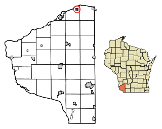
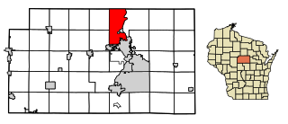
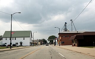
Necedah is a village in Juneau County, Wisconsin, United States. The population was 916 at the 2020 census. The village is located within the Town of Necedah.

<span class="mw-page-title-main">Milltown, Wisconsin</span> Village in Wisconsin, United States

Milltown is a village in Polk County, Wisconsin, United States. The population was 917 at the 2010 census. The village is located within the Town of Milltown.

<span class="mw-page-title-main">Scandinavia, Wisconsin</span> Village in Wisconsin, United States

Scandinavia is a village in the Town of Scandinavia in Waupaca County, Wisconsin, United States. The population was 328 at the 2010 census.

References

  1. (2022) League of Wisconsin Municipalities. Directory of Cities & Villages. Pg. 79 of 135.
  2. "2019 U.S. Gazetteer Files". United States Census Bureau. Retrieved August 7, 2020.
  3. 1 2 "US Board on Geographic Names". United States Geological Survey. October 25, 2007. Retrieved January 31, 2008.
  4. 1 2 "U.S. Census website". United States Census Bureau . Retrieved November 18, 2012.
  5. 1 2 "Population and Housing Unit Estimates". United States Census Bureau. May 24, 2020. Retrieved May 27, 2020.
  6. 1 2 "U.S. Census website". United States Census Bureau . Retrieved January 31, 2008.
  7. "US Gazetteer files: 2010, 2000, and 1990". United States Census Bureau. February 12, 2011. Retrieved April 23, 2011.
  8. "US Gazetteer files 2010". United States Census Bureau. Archived from the original on July 2, 2012. Retrieved November 18, 2012.
  9. "Census of Population and Housing". Census.gov. Retrieved June 4, 2015.
  10. Biographical Sketch of Rufus M. Day, Wisconsin Blue Book 1887, pg. 498