
The Mississippi River is the second-longest river and chief river of the second-largest drainage system on the North American continent, second only to the Hudson Bay drainage system. From its traditional source of Lake Itasca in northern Minnesota, it flows generally south for 2,320 miles (3,730 km) to the Mississippi River Delta in the Gulf of Mexico. With its many tributaries, the Mississippi's watershed drains all or parts of 32 U.S. states and two Canadian provinces between the Rocky and Appalachian mountains. The main stem is entirely within the United States; the total drainage basin is 1,151,000 sq mi (2,980,000 km2), of which only about one percent is in Canada. The Mississippi ranks as the fourth-longest river and fifteenth-largest river by discharge in the world. The river either borders or passes through the states of Minnesota, Wisconsin, Iowa, Illinois, Missouri, Kentucky, Tennessee, Arkansas, Mississippi, and Louisiana.

The Illinois River is a principal tributary of the Mississippi River and is approximately 273 miles (439 km) long. Located in the U.S. state of Illinois, the river drains a large section of central Illinois, with a drainage basin of 28,756.6 square miles (74,479 km2). The drainage basin extends into Wisconsin, Indiana, and a very small area of southwestern Michigan.

Cairo is the southernmost city in the U.S. state of Illinois, and is the county seat of Alexander County.

Galena is the largest city in and the county seat of Jo Daviess County, Illinois, with a population of 3,429 at the 2010 census. A 581-acre (235 ha) section of the city is listed on the National Register of Historic Places as the Galena Historic District. The city is named for the mineral galena, which was in the ore that formed the basis for the region's early mining economy.

Alton is a city on the Mississippi River in Madison County, Illinois, United States, about 18 miles (29 km) north of St. Louis, Missouri. The population was 27,865 at the 2010 census. It is a part of the Metro-East region of the Greater St. Louis metropolitan area. It is famous for its limestone bluffs along the river north of the city, for its role preceding and during the American Civil War. It was the site of the last Abraham Lincoln and Stephen Douglas debate in October 1858. The former state penitentiary in Alton was used during the Civil War to hold up to 12,000 Confederate prisoners of war.

The Wisconsin River is a tributary of the Mississippi River in the U.S. state of Wisconsin. At approximately 430 miles (692 km) long, it is the state's longest river. The river's name, first recorded in 1673 by Jacques Marquette as "Meskousing", is rooted in the Algonquian languages used by the area's American Indian tribes, but its original meaning is obscure. French explorers who followed in the wake of Marquette later modified the name to "Ouisconsin", and so it appears on Guillaume de L'Isle's map. This was simplified to "Wisconsin" in the early 19th century before being applied to Wisconsin Territory and finally the state of Wisconsin.

The Meramec River, sometimes spelled Maramec River is one of the longest free-flowing waterways in the U.S. state of Missouri, draining 3,980 square miles (10,300 km2) while wandering 218 miles (351 km) from headwaters near Salem to where it empties into the Mississippi River near St. Louis at Arnold and Oakville. The Meramec watershed covers six Missouri Ozark Highland counties—Dent, Phelps, Crawford, Franklin, Jefferson, and St. Louis—and portions of eight others—Maries, Gasconade, Iron, Washington, Reynolds, St. Francois, Ste. Genevieve, and Texas. Between its source and its mouth, it falls 1,025 feet (312 m). Year-round navigability begins above Maramec Spring, just south of St. James. The Meramec's size increases at the confluence of the Dry Fork, and its navigability continues until the river enters the Mississippi at Arnold, Missouri.
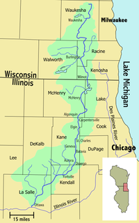
The Fox River is a 202-mile-long (325 km) tributary of the Illinois River, flowing from southeastern Wisconsin to Ottawa, Illinois in the United States. The Wisconsin section was known as the Pishtaka River in the 19th century. There are two other "Fox Rivers" in southern Illinois: the Fox River and a smaller "Fox River" that joins the Wabash River near New Harmony, Indiana.

The Rock River is a tributary of the Mississippi River, approximately 299 miles (481 km) long, in the U.S. states of Wisconsin and Illinois. The river was known as the Sinnissippi to Sauk and Fox Indians; the name means "rocky waters".

The Ross Barnett Reservoir is a reservoir of the Pearl River between Madison and Rankin counties in the U.S. state of Mississippi. The 33,000-acre (130 km2) lake serves as the state's largest drinking water resource, and is managed by the Pearl River Valley Water Supply District. The lake features 105 miles (169 km) of shoreline impounded on the south by a 3.5-mile (5.6 km) man-made dam and spillway. The western shore is bounded by the historic Natchez Trace Parkway.

The Driftless Area is a region in southwestern Wisconsin, southeastern Minnesota, northeastern Iowa, and the extreme northwestern corner of Illinois, of the American Midwest. The region escaped the flattening effects of glaciation during the last ice age and is consequently characterized by steep, forested ridges, deeply carved river valleys, and karst geology characterized by spring-fed waterfalls and cold-water trout streams. Ecologically, the Driftless Area's flora and fauna are more closely related to those of the Great Lakes region and New England than those of the broader Midwest and central Plains regions. Colloquially, the term includes the incised Paleozoic Plateau of southeastern Minnesota and northeastern Iowa. The region includes elevations ranging from 603 to 1,719 feet at Blue Mound State Park and covers 24,000 square miles (62,200 km2). The rugged terrain is due both to the lack of glacial deposits, or drift, and to the incision of the upper Mississippi River and its tributaries into bedrock.

Coorow is a town in the Mid West region of Western Australia, 264 kilometres (164 mi) north of Perth.
In the United States, there are multiple laws known as the Flood Control Act (FCA). Typically, they are enacted to control irrigation because of floods or other natural disasters and are administered by the United States Army Corps of Engineers. These laws were enacted beginning in 1917, with the most recent one being passed in 1965.

Knights Ferry is an unincorporated historic community in Stanislaus County, California, United States. Nestled in the foothills of the Sierra Nevada, it is about 40 miles (64 km) east of Modesto on the Stanislaus River. The Willms Ranch, a California Landmark near the town, was one of many filming locations for the television series Bonanza and Little House on the Prairie. It is home to the Knights Ferry Bridge, the longest covered bridge west of the Mississippi at 330 feet (100 m) in length. Today, it is home to a K-8 Elementary School, and a museum about the history of the town and also about local wildlife. The town's ruins include a mill and a jail.
Wittenberg is an unincorporated community in Brazeau Township in eastern Perry County, Missouri, United States. It is located on the Mississippi River, 14 miles (23 km) southeast of Perryville. Wittenberg is situated in the Brazeau Bottoms on Brazeau Creek opposite Grand Tower, Illinois, and Tower Rock, the latter a landmark island in the Mississippi River.

The Great Dayton Flood of 1913 resulted from flooding by the Great Miami River reaching Dayton, Ohio, and the surrounding area, causing the greatest natural disaster in Ohio history. In response, the General Assembly passed the Vonderheide Act to enable the formation of conservancy districts. The Miami Conservancy District, which included Dayton and the surrounding area, became one of the first major flood control districts in Ohio and the United States.
Floods in the United States before 1901 is a list of flood events that were of significant impact to the country, before 1901. Floods are generally caused by excessive rainfall, excessive snowmelt, and dam failure.

The June 2008 Midwestern United States floods were flooding events which affected portions of the Midwestern United States. After months of heavy precipitation, a number of rivers overflowed their banks for several weeks at a time and broke through levees at numerous locations. Flooding continued into July. States affected by the flooding included Illinois, Indiana, Iowa, Michigan, Minnesota, Missouri and Wisconsin. The American Red Cross assisted the victims of flooding and tornadoes across seven states and the National Guard was mobilized to assist in disaster relief and evacuation.

Eastport is an unincorporated community in Tishomingo County, Mississippi, United States. During the 1840s and 1850s, Eastport became an important river port and boasted a population of 2,000 and many businesses. In 1857, the railroad missed Eastport and the townspeople began moving to nearby Iuka. During the American Civil War, the town again became an important river port, but by the 1890s the post office closed. When the Tennessee River was dammed to create Pickwick Lake in the 1930s, the old town was submerged. Eastport still exists as a small community with a marina.


