North Lancaster, Wisconsin

Last updated

North Lancaster, Wisconsin
North Lancaster Town Hall.jpg
Town hall
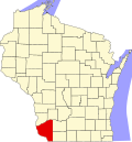
WIMap-doton-North Lancaster.png
Location of North Lancaster, Wisconsin
Coordinates: 42°54′2″N90°43′13″W / 42.90056°N 90.72028°W / 42.90056; -90.72028
Country Flag of the United States.svg  United States
State Flag of Wisconsin.svg  Wisconsin
County Grant
Area
  Total36.0 sq mi (93.3 km2)
  Land36.0 sq mi (93.3 km2)
  Water0.0 sq mi (0.0 km2)
Elevation
[1]
922 ft (281 m)
Population
 (2000)
  Total515
  Density14.3/sq mi (5.5/km2)
Time zone UTC-6 (Central (CST))
  Summer (DST) UTC-5 (CDT)
Area code 608
FIPS code 55-58125 [2]
GNIS feature ID1583830 [1]

North Lancaster is a town in Grant County, Wisconsin, United States. The population was 515 at the 2000 census.

Contents

Geography

According to the United States Census Bureau, the town has a total area of 36.0 square miles (93.3 km2), of which, 36.0 square miles (93.3 km2) of it is land and 0.03% is water.

Demographics

At the 2000 census there were 515 people, 164 households, and 142 families living in the town. The population density was 14.3 people per square mile (5.5/km2). There were 170 housing units at an average density of 4.7 per square mile (1.8/km2). The racial makeup of the town was 99.03% White, 0.39% Asian, and 0.58% from two or more races. Hispanic or Latino of any race were 0.19%. [2]

Of the 164 households 48.8% had children under the age of 18 living with them, 78.0% were married couples living together, 2.4% had a female householder with no husband present, and 13.4% were non-families. 10.4% of households were one person and 4.9% were one person aged 65 or older. The average household size was 3.14 and the average family size was 3.35.

The age distribution was 34.0% under the age of 18, 5.8% from 18 to 24, 28.2% from 25 to 44, 24.1% from 45 to 64, and 8.0% 65 or older. The median age was 37 years. For every 100 females, there were 111.1 males. For every 100 females age 18 and over, there were 108.6 males.

The median household income was $41,528 and the median family income was $43,750. Males had a median income of $27,361 versus $19,688 for females. The per capita income for the town was $17,038. About 7.9% of families and 10.6% of the population were below the poverty line, including 15.2% of those under age 18 and 5.3% of those age 65 or over.

Related Research Articles

<span class="mw-page-title-main">Sylvan Springs, Alabama</span> Town in Alabama, United States

Sylvan Springs is a town in Jefferson County, Alabama, United States, located northwest of the Birmingham suburb of Pleasant Grove. It incorporated on May 22, 1957. At the 2010 census the population was 1,542, up from 1,465 in 2000. This area was damaged by an F5 tornado on April 8, 1998, including the First United Methodist Church of Sylvan Springs.

<span class="mw-page-title-main">Warren, Indiana</span> Town in Indiana, United States

Warren is a town in Salamonie Township, Huntington County, Indiana. The population of Warren was 1,182 at the time of the 2020 census.

<span class="mw-page-title-main">Bethany, Indiana</span> Town in Indiana, United States

Bethany is a town in Clay Township, Morgan County, in the U.S. state of Indiana. The population was 95 at the 2020 census.

Chester is a town in Penobscot County, Maine, United States. The population was 549 at the 2020 census.

Cornville is a town in Somerset County, Maine, United States. The population was 1,317 at the 2020 census.

Danforth is a town in Washington County, Maine, United States. The town was named for proprietor Thomas Danforth. The population was 587 at the 2020 census. The town contains the villages of Danforth and Eaton. East Grand High School is located in Danforth.

<span class="mw-page-title-main">Billington Heights, New York</span> Census-designated place in New York, United States

Billington Heights is a hamlet and census-designated place (CDP) in the towns of Elma and Aurora in Erie County, New York, United States. The population was 1,685 at the 2010 census. It is part of the Buffalo–Niagara Falls Metropolitan Statistical Area.

<span class="mw-page-title-main">Huttonsville, West Virginia</span> Town in West Virginia, United States

Huttonsville is a town in Randolph County, West Virginia, United States, along the Tygart Valley River. The population was 163 at the 2020 census.

<span class="mw-page-title-main">Auburn, West Virginia</span> Town in West Virginia, United States

Auburn is a town in Ritchie County, West Virginia, United States. The population was 80 at the 2020 census.

<span class="mw-page-title-main">Pennsboro, West Virginia</span> City in West Virginia, United States

Pennsboro is a city in Ritchie County, West Virginia, United States. The population was 1,050 at the 2020 census. The city is located at the junction of U.S. Route 50 and West Virginia Route 74; the North Bend Rail Trail also passes through the city.

<span class="mw-page-title-main">Morse, Wisconsin</span> Town in Wisconsin, United States

Morse is a town in Ashland County in the U.S. state of Wisconsin. The population was 493 at the 2010 census. The unincorporated communities of Ballou, Cayuga, Foster Junction, and Penokee are located in the town.

<span class="mw-page-title-main">Orienta, Wisconsin</span> Town in Wisconsin, United States

Orienta is a town in Bayfield County, Wisconsin, United States. The population was 164 at the 2020 census, up from 122 at the 2010 census.

<span class="mw-page-title-main">Sterling, Polk County, Wisconsin</span> Town in Wisconsin, United States

Sterling is a town in Polk County, Wisconsin, United States. The population was 724 at the 2000 census. The unincorporated communities of Cushing and Wolf Creek are located partially in the town.

<span class="mw-page-title-main">Georgetown, Price County, Wisconsin</span> Town in Wisconsin, United States

Georgetown is a town in Price County, Wisconsin, United States. The population was 164 at the 2000 census.

<span class="mw-page-title-main">Wolf River, Winnebago County, Wisconsin</span> Town in Wisconsin, United States

Wolf River is a town in Winnebago County, Wisconsin, United States. The population was 1,189 at the 2010 census. The unincorporated communities of Orihula and Zittau are located in the town. The unincorporated community of Metz is also located partially in the town.

<span class="mw-page-title-main">Hulett, Wyoming</span> Town in Wyoming, United States

Hulett is a town in Crook County, Wyoming, United States. The population was 309 at the 2020 census.

<span class="mw-page-title-main">South Oxford, Maine</span> Unorganized territory in Maine, United States

South Oxford is an unorganized territory located in Oxford County, Maine, United States. The population was 591 at the 2020 census. The unorganized territory encompasses the areas designated under state law as Albany Township, Mason Township, and Batchelder's Grant. Albany and Mason were formerly incorporated as towns. Albany disincorporated in 1937 while Mason disincorporated in 1935.

<span class="mw-page-title-main">Hustisford (town), Wisconsin</span> Town in Wisconsin, United States

Hustisford is a town in Dodge County, Wisconsin, United States. The population was 1,379 at the 2000 census. Most of the town residents live in the village of Hustisford, within the town.

<span class="mw-page-title-main">Melrose (town), Wisconsin</span>

Melrose is a town in Jackson County, Wisconsin, United States. The population was 402 at the 2000 census. The Village of Melrose is located within the town.

<span class="mw-page-title-main">Gillett, Wisconsin</span> City in Wisconsin, United States

Gillett is a city in Oconto County, Wisconsin, United States. The population was 1,386 at the 2010 census. It is part of the Green Bay Metropolitan Statistical Area. The city is adjacent to the Town of Gillett.

References

  1. 1 2 "US Board on Geographic Names". United States Geological Survey. October 25, 2007. Retrieved January 31, 2008.
  2. 1 2 "U.S. Census website". United States Census Bureau . Retrieved January 31, 2008.