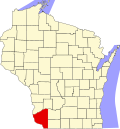
Boscobel (town), Wisconsin

Last updated

Boscobel, Wisconsin
WIMap-doton-Boscobel.png
Location of Boscobel, Wisconsin
Coordinates: 43°8′17″N90°41′41″W / 43.13806°N 90.69472°W / 43.13806; -90.69472
Country Flag of the United States.svg  United States
State Flag of Wisconsin.svg  Wisconsin
County Grant
Area
  Total7.3 sq mi (18.9 km2)
  Land6.8 sq mi (17.7 km2)
  Water0.5 sq mi (1.2 km2)
Elevation
[1]
673 ft (205 m)
Population
 (2000)
  Total433
  Density63.4/sq mi (24.5/km2)
Time zone UTC-6 (Central (CST))
  Summer (DST) UTC-5 (CDT)
Area code 608
FIPS code 55-08875 [2]
GNIS feature ID1582844 [1]

Boscobel is a town in Grant County, Wisconsin, United States. The population was 433 at the 2000 census. The town borders the city of Boscobel.

Contents

Geography

According to the United States Census Bureau, the town has a total area of 7.3 square miles (18.9 km2), of which, 6.8 square miles (17.7 km2) of it is land and 0.5 square miles (1.2 km2) of it (6.44%) is water.

Demographics

At the 2000 census there were 433 people, 190 households, and 124 families living in the town. The population density was 63.4 people per square mile (24.5/km2). There were 199 housing units at an average density of 29.1 per square mile (11.2/km2). The racial makeup of the town was 99.31% White, and 0.69% from two or more races. 0.23% of the population were Hispanic or Latino of any race. [2] Of the 190 households 22.1% had children under the age of 18 living with them, 57.9% were married couples living together, 2.6% had a female householder with no husband present, and 34.7% were non-families. 31.6% of households were one person and 15.8% were one person aged 65 or older. The average household size was 2.28 and the average family size was 2.80.

The age distribution was 19.9% under the age of 18, 7.2% from 18 to 24, 23.8% from 25 to 44, 29.8% from 45 to 64, and 19.4% 65 or older. The median age was 44 years. For every 100 females, there were 105.2 males. For every 100 females age 18 and over, there were 104.1 males.

The median household income was $32,841 and the median family income was $39,250. Males had a median income of $30,417 versus $21,875 for females. The per capita income for the town was $18,964. About 3.2% of families and 8.1% of the population were below the poverty line, including none of those under age 18 and 7.8% of those age 65 or over.

Related Research Articles

<span class="mw-page-title-main">Steele, Alabama</span> Town in Alabama, United States

Steele is a town in northeastern St. Clair County, Alabama, United States. It was incorporated in 1952. At the 2010 census the population was 1,043, down from 1,093. The town is a part of the Birmingham–Hoover–Cullman Combined Statistical Area. It was initially known as Steel's Station or Steele's Depot in the late 19th century.

<span class="mw-page-title-main">Markle, Indiana</span> Town in Indiana, United States

Markle is a town in Huntington and Wells counties, in the U.S. state of Indiana. The population was 1,071 at the 2020 census. It lies along Interstate 69, U.S. Route 224, State Road 116 and State Road 3.

<span class="mw-page-title-main">Lewis, Iowa</span> City in Iowa, United States

Lewis is a city in Cass County, Iowa, United States, along the East Nishnabotna River. The population was 357 at the time of the 2020 census.

<span class="mw-page-title-main">Perham, Maine</span> Town in the state of Maine, United States

Perham is a town in Aroostook County, Maine, United States. The population was 371 at the 2020 census. The town was named after Maine's 33rd governor, Sidney Perham.

<span class="mw-page-title-main">Pasadena Hills, Missouri</span> City in Missouri, United States

Pasadena Hills is a city in St. Louis County, Missouri, United States. The population was 930 at the 2010 census. The entire city is listed on the National Register of Historic Places.

<span class="mw-page-title-main">Leesburg, Ohio</span> Village in Ohio, United States

Leesburg is a village in Highland County, Ohio, United States. The population was 1,273 at the 2020 census.

<span class="mw-page-title-main">Kendrick, Oklahoma</span> Town in Oklahoma, United States

Kendrick is a town in Lincoln County, Oklahoma, United States. The population was 139 at the 2010 census.

<span class="mw-page-title-main">Pennsboro, West Virginia</span> City in West Virginia, United States

Pennsboro is a city in Ritchie County, West Virginia, United States. The population was 1,050 at the 2020 census. The city is located at the junction of U.S. Route 50 and West Virginia Route 74; the North Bend Rail Trail also passes through the city.

<span class="mw-page-title-main">Chippewa, Wisconsin</span> Town in Wisconsin, United States

Chippewa is a town in Ashland County in the U.S. state of Wisconsin. The population was 374 at the 2010 census.

<span class="mw-page-title-main">Holland, Brown County, Wisconsin</span> Town in Wisconsin, United States

Holland is a town in Brown County in the U.S. state of Wisconsin. The population was 1,519 at the 2010 census. The unincorporated communities of Askeaton and Hollandtown are located in the town.

<span class="mw-page-title-main">Marion, Juneau County, Wisconsin</span> Town in Wisconsin, United States

Marion is a town in Juneau County, Wisconsin, United States. The population was 433 at the 2000 census.

<span class="mw-page-title-main">Little Rice, Wisconsin</span> Town in Wisconsin, United States

Little Rice is a town in Oneida County, Wisconsin, United States. The population was 314 at the 2000 census. The unincorporated community of McCord is located in the town.

<span class="mw-page-title-main">Nokomis, Wisconsin</span> Town in Wisconsin, United States

Nokomis is a town in Oneida County, Wisconsin, United States. The population was 1,371 at the 2010 census.

<span class="mw-page-title-main">Georgetown, Polk County, Wisconsin</span> Town in Wisconsin, United States

Georgetown is a town in Polk County, Wisconsin, United States. The population was 977 at the 2010 census. The unincorporated communities of Bunyan and Fox Creek are located in the town.

<span class="mw-page-title-main">Greenbush, Wisconsin</span> Town in Wisconsin, United States

Greenbush is a town in Sheboygan County, Wisconsin, United States. The population was 2,773 at the 2000 census. It is included in the Sheboygan, Wisconsin Metropolitan Statistical Area. The census-designated place of Greenbush is located in the town. The unincorporated community of German Corners is also located in the town.

<span class="mw-page-title-main">Richford, Wisconsin</span> Town in Wisconsin, United States

Richford is a town in Waushara County, Wisconsin, United States. The population was 588 at the 2000 census.

Lowell is a town in Dodge County, Wisconsin, United States. The population was 1,169 at the 2000 census. The Village of Lowell and the unincorporated community of North Lowell are located in the town.

<span class="mw-page-title-main">Boscobel, Wisconsin</span> City in Wisconsin, United States

Boscobel is a city in Grant County, Wisconsin, United States. The population was 3,286 at the 2020 census. Approximately 0.6 mi. (1 km) to the north of the city, across a riparian swamp, is the Wisconsin River. U.S. Route 61 crosses the Wisconsin River at Boscobel. To the south, the city is bordered by the Town of Boscobel.

<span class="mw-page-title-main">Hixton, Wisconsin</span> Village in Wisconsin, United States

Hixton is a village in Jackson County, Wisconsin, United States, along the Trempealeau River. The population was 433 at the 2010 census. The village is located within the Town of Hixton.

<span class="mw-page-title-main">Hammond, Wisconsin</span> Village in Wisconsin, United States

Hammond is a village in St. Croix County, Wisconsin, United States. The population was 1,922 at the 2010 census. The village is located within the Town of Hammond. Hammond was home to the Running of the Llamas.

References

  1. 1 2 "US Board on Geographic Names". United States Geological Survey. October 25, 2007. Retrieved January 31, 2008.
  2. 1 2 "U.S. Census website". United States Census Bureau . Retrieved January 31, 2008.