
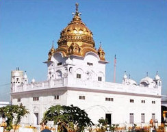
Batala is the eighth largest city in the state of Punjab, India in terms of population after Ludhiana, Amritsar, Jalandhar, Patiala, Bathinda, Mohali and Hoshiarpur. Batala ranks as the second oldest city after Bathinda. It is a municipal corporation in Gurdaspur District in the Majha region of the state of Punjab, India. It is located about 32 km from Gurdaspur, the headquarters of the district. It is also a Police District. Batala holds the status of the most populated town of the district with 31% of the total population of district. It is the biggest industrial town in the district. Batala is the centre of the Majha region of Punjab.

Doaba also known as Bist Doab, is the region of Punjab, India that lies between the Beas River and the Sutlej River. People of this region are given the demonym "Doabia". The dialect of Punjabi spoken in Doaba is called "Doabi". The term "Doaba" or "Doab" is derived from Persian "دو آب" meaning "land of two rivers". The river Sutlej separates Doaba from the Malwa region to its south and the river Beas separates Doaba from the Majha region to its north.This region is mainly known for Saini'S Yadubanshi rajput area.
Balachaur is a town in Balachaur Tehsil in the Shaheed Bhagat Singh Nagar District of Punjab, India.
Dera Baba Nanak is a town and a Municipal council in Gurdaspur district in the state of Punjab, India. Recently, a corridor between India and Pakistan has been established at its shrine.
Fatehgarh Churian is a city located in Punjab, India. It is a municipal council of the Gurdaspur district. The city lies 15 kilometres from the Pakistani border. It is located 485 kilometres north of New Delhi, India.

Safidon is a city and a municipal committee in Jind district in the Indian state of Haryana.
Giddarbaha, is a town and a municipal council in Muktsar district, in the Indian state of Punjab.
Ajiwal is a village, situated on the National Highway no. 95, in the tehsil and district of Moga in Eastern Punjab (India). It is 16 km away from Moga and 14 km away from Jagraon.

Pubowal is a village in Una district in the Indian state of Himachal Pradesh.
Chauke is a town of Malwa in the Bathinda district of Punjab state, India. It comes under the Maur Mandi assembly constituency. It shares its boundaries with Mansa and Barnala districts of Punjab.
Kartarpur is a town near the city of Jalandhar and is located in the Doaba region of the state. It was founded by the fifth Guru of Sikhs, Sri Guru Arjan Dev Ji.
Dhudike is a village in Moga-I Tehsil in Moga district of Punjab state, India. It is located 17 km east from District Moga. Freedom fighters like Baba Ishar Singh, Baba Pala Singh Jathedar, Baba Pakhar Singh are a few of the Gadaree from Dhudike who participated in the Gadar Movement during the struggle for independence. Dhudike was the birthplace of the famous Lala Lajpat Rai. Furthermore, during the infamous Emergency days of the 70s, underground activity supporting the ideals of the Naxalite communist movement were prevalent in this area. Such topics are touched upon by renowned Punjabi writer Jaswant Singh Kanwal, who is also from Dhudike.
Talhan is a village in Jalandhar district, near the Jalandhar Cantonment, in Punjab, India.
Pharala is a village in the tehsil of Nawanshahr, Nawanshahr district, in Punjab, India.
Buttar Sarinh, incorrect spellings include Buttar Shrin and Buttar Shri, is a small village in the Giddarbaha tehsil of Sri Muktsar Sahib district in Punjab, India. It's located on the Sri Muktsar Sahib-Bathinda main road.
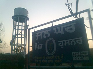
Husnar is a village located in the Giddarbaha tehsil of Sri Muktsar Sahib district in Punjab, India.
Apra is a census town in Phillaur Tehsil in Jalandhar district of Punjab State, India. The town is known for gold jewelry and paddy crops which are produced in large amounts. It is located 46 kilometres (29 mi) towards East from Jalandhar, 12 kilometres (7.5 mi) from Phillaur and 110 kilometres (68 mi) from Chandigarh. Apra is the largest town as compared to other surrounding villages and has the main marketplace. The town is administrated by Sarpanch an elected representative of the village.
Samrari is a village in Phillaur tehsil of Jalandhar District of Punjab State, India. The village is administrated by Sarpanch who is elected representative of village. It is 2.7 km away from census town Apra and 2.3 km from Jajja Khurd. Samrari is located 4.7 km from postal head office Bara Pind, 42.3 km towards East from Jalandhar, 13.9 km from Phillaur and 121 km from Chandigarh.
Nagar is a village in the Phillaur tehsil of Jalandhar District of the Indian state of Punjab. It is located on Phillaur-Nawanshahr Road, 6.7 kilometres (4.2 mi) from the head postal office in Phillaur, 7 kilometres (4.3 mi) from Apra, 50 kilometres (31 mi) from Jalandhar, and 117 kilometres (73 mi) from the state capital of Chandigarh. The village is administered by the Sarpanch, an elected representative.
Sajjana is a village in Hoshiarpur tehsil of Hoshiarpur district in Punjab, India.
