The Burin Peninsula is a peninsula located on the south coast of the island of Newfoundland in the province of Newfoundland and Labrador. Marystown is the largest population centre on the peninsula.
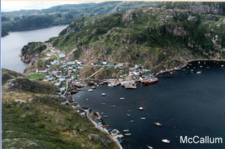
McCallum is a local service district and designated place in the Canadian province of Newfoundland and Labrador. It is on the southern coast of the island of Newfoundland. It is accessible only by boat or by air, and in appearance and way of life is thought by some to be as close to a pre-20th century community as may be found. McCallum lies in an enclosed harbour and is sheltered between two hills. The community survives primarily on the fishery. Whaling was also a major industry in the late 19th century. It is also about an hour and a half from the nearest road, in a community called Hermitage.

Terrenceville is a small town located on the Burin Peninsula of Newfoundland, Canada, south west of Swift Current.
Fortune Bay is a fairly large natural bay located in the Gulf of St. Lawrence on the south coast of Newfoundland, Canada. The Bay is bounded by Point Crewe on the Burin Peninsula and Pass Island at the entrance to Hermitage Bay to the northwest for a distance of 56 kilometers. The bay extends in a northeast direction for 105 kilometers ending at Terrenceville.

Rencontre East is a small, outport community in Newfoundland and Labrador, Canada located north east of Belleoram, and west of Terrenceville in Fortune Bay. The population was 115 in the 2021 census. This small community is not connected to any surrounding areas by road but is accessible by scheduled ferry service from ports in Pool's Cove and Bay L'Argent.
Indian Bay (Parsons Point) is located in Newfoundland, Canada.

English Harbour East is a town in the Canadian province of Newfoundland and Labrador. It is located on the northeast side of Fortune Bay. Settled first by the Mi’kmaq of Newfoundland which used land on the "Neck" of the Harbour, they were joined in the early 1800s, by the English Dodge family and by Irishman Thomas Hynes Sr. European fishermen were first brought to the small community by English merchant family of Newman and Co. based in Harbour Breton, the firm of merchant John Gorman, and the Jersey firm of Nicholle and Co. The town had a population of 117 in the Canada 2021 Census.
North River is a town on the Avalon Peninsula of Newfoundland in the Canadian province of Newfoundland and Labrador. It was incorporated as a municipality in 1964.
Fortune Harbour or Fortune Harbor is a designated place in the Canadian province of Newfoundland and Labrador.

La Poile is a local service district and designated place in the Canadian province of Newfoundland and Labrador. It is on La Poile Bay. The community is inaccessible by road and is served by a ferry via a port in Rose Blanche.
Conne was a community in Newfoundland and Labrador, Canada located on the Northern shore of Fortune Bay. It was first reported to be settled in 1836, in the first Census of Newfoundland with sixteen inhabitants. It was a severely isolated settlement, which had no church or school and very little land for growing crops, and it based its existence on the inshore fishery of cod, lobster, salmon and herring.

Little Placentia Sound is an abandoned town in Newfoundland and Labrador that had a peak population of 47 in 1901. It is named after the body of water (sound) that encompasses the former community located within Placentia Bay on the Avalon Peninsula in the Canadian province of Newfoundland and Labrador. There was once a lead mine called Silver Cliff Mine located within the town.
Prowseton, formerly known as Civilly's Cove, Sibley's Cove, or Civil East Cove, is an abandoned town in Newfoundland and Labrador that had a population of 28 in 1966. Its name was changed in 1915 to avoid confusion with the nearby town of Sibley's Cove in Trinity Bay and to honour Judge D.W. Prowse. The town was mostly abandoned by the mid 1960s but had a few residents up until the 1990s.

Rose au Rue is an abandoned whaling town in Newfoundland and Labrador, Canada that had a small population of 11 in 1891.
Pays Cove is an abandoned town in Newfoundland and Labrador, Canada that had a peak population of 11 in 1935.
Trammer is an abandoned town in Newfoundland and Labrador, Canada that had a peak population of 15 in 1901.
New Harbour is an abandoned town located within Fortune Bay in Newfoundland and Labrador, Canada that had a peak population of 24 in 1945. It is not to be confused with New Harbour, Trinity Bay and New Harbour on the south-west coast of Newfoundland.
Jemmy's Cove is a tiny abandoned town located near New Harbour, Fortune Bay in Newfoundland and Labrador, Canada that had a peak population of 6 in 1911.
North West Arm was a community near Valleyfield in Bonavista Bay, Newfoundland. It was located on the southwest side of a long indraft of the same name and was settled about 1880, but was abandoned by 1960. North West Arm first appeared in the 1891 census with a population of 77. In the 1935 census, this had increased to 143 people, and by 1945 it had climbed further to 153, before reaching a peak of 160 in 1951. The area once occupied by North West Arm is now within the boundaries of the town of New-Wes-Valley.
