
Kochi, also known by its former name Cochin, is a major port city along the Malabar Coast of India bordering the Laccadive Sea. It is part of the district of Ernakulam in the state of Kerala. The city is also commonly referred to as Ernakulam. As of 2011, the Kochi Municipal Corporation had a population of 677,381 over an area of 94.88 km2, and the larger Kochi urban agglomeration had over 2.1 million inhabitants within an area of 440 km2, making it the largest and the most populous metropolitan area in Kerala. Kochi city is also part of the Greater Cochin development region and is classified as a Tier-II city by the Government of India. The civic body that governs the city is the Kochi Municipal Corporation, which was constituted in the year 1967, and the statutory bodies that oversee its development are the Greater Cochin Development Authority (GCDA) and the Goshree Islands Development Authority (GIDA).
Ernakulam is one of the 14 districts in the Indian state of Kerala, and takes its name from the eponymous city division in Kochi. It is situated in the central part of the state, spans an area of about 2,924 square kilometres (1,129 sq mi), and is home to over 9% of Kerala's population. Its headquarters are located at Kakkanad. The district includes Kochi, also known as the commercial capital of Kerala, which is famous for its ancient churches, Hindu temples, synagogues and mosques.
Kochukadavanthra (Cheriakadavanthra) is a small area of Elamkulam village in Ernakulam district of Kerala, south India. The nearest big city is Ernakulam. Kochukadavanthra situated in the west bank of the Perandoor Kanal south end. Residential area of Kasthurba Nagar and south Panampilly Nagar belongs to Kochukadavanthra. You can reach at Kochukadavanthra by traveling two kilometer south side from Panampally Nagar Junction through Panampally Nagar avenue Road.

Ernakulam is the central business district of the city of Kochi, Kerala, India. It is the namesake of Ernakulam district. The eastern part of Kochi city is mainly known as Ernakulam, while the western part of it after the Venduruthy Bridge is called as Western Kochi. Many major establishments, including the Kerala High Court, the office of the Kochi Municipal Corporation and the Cochin Shipyard are situated in Ernakulam. It is also the most urbanized area in the city of Kochi.
Kumbalathuparambu Ayyappan, better identified as Sahodaran Ayyappan, was a social reformer, thinker, rationalist, journalist, and politician from Kerala, India. As a vocal follower of Sree Narayana Guru, he was associated with a number of events related to the Kerala reformation movement and was the organizer of Misra Bhojanam in Cherai in 1917. He founded Sahodara Sangam, and the journal Sahodaran and was the founder editor of the magazine Yukthivadi.

Greater Cochin Development Authority (GCDA) is the statutory body overseeing the development of the city of Kochi in the state of Kerala, India. Headquartered at Kadavanthra, GCDA oversees the development of the major part of Greater Cochin area which consists of the Kochi Municipal Corporation, surrounding municipalities and 21 intervening panchayats covering an area of 632 km2.
Kochi is a major port city in the Indian state of Kerala. The city is widely known as the commercial or economic capital of the state of Kerala.

Kadavanthra is a ward in downtown Kochi, Kerala. It is bounded by the S.A Road to the east and the Giri Nagar canal in the west. Kadavanthra is a major commercial centre of Kochi, and a prime residential area. In recent years, the ward has undergone rapid development to become one of Kochi's highest-valued regions.
The Kochi Metro is a rapid transit system serving the city of Kochi and the wider Kochi Metropolitan Region in Kerala, India. It was opened to the public within four years of starting construction, making it one of the fastest completed metro projects in India. The Kochi metro project is the first metro system in the country which connects rail, road and water transport facilities. It is also the first metro rail system in India to be operated using the Communication-Based Train Control (CBTC) signalling system, which requires minimum human intervention. The Kochi Water Metro is integrated with the Kochi Metro, which also serves as a feeder service to the suburbs along the rivers where transport accessibility is limited.

Elamkulam is a ward of Kochi, Kerala. Elamkulam is a part of the Kadavanthra pincode and Kadavanthra Janamythri Police station. Elamkulam is well facilitated with Metro railway station which works as an extension counter to Kadavanthra metro station to cater to passengers who want to shop at branded outlets like MAX,Trends etc. Elamkulam metro station also privileges direct entry to Radisson Blu Kochi.
Nettoor is a region in the city of Kochi. It is around 5 km (3.1 mi) from Vytilla Junction and around 8 km (5.0 mi) from Ernakulam Junction Railway Station. Nettoor is located on Panangad Island and is a part of Maradu Municipality.
Vyttila, IPA:[ʋɐjt̺ːilɐ], is a region in the city of Kochi, Kerala. The Vyttila junction is one of the busiest as well as one of the largest intersections in Kerala. This node intersects the main north–south artery of the state of Kerala, namely, the Kochi Bypass, with three city roads of Kochi viz, the S. A. Road, the Vyttila-Petta Road, and the Thammanam Road.

Kaloor is a downtown region in the city of Kochi, in the state of Kerala, India. It is two kilometres (1.2 mi) from the Ernakulam North Railway Station. Kaloor Junction is also the name of a major intersection in this part of the city, intersecting the two major arteries of downtown Kochi, namely Banerji Road and the Kaloor-Kadavanthra Road. The nearest major intersections are Palarivattom to the east and Lissie Junction to the west.

Mahatma Gandhi Road, popularly known as M. G. Road, is the main artery as well as the commercial high street of the city of Kochi, in the state of Kerala, India. The road lies north-south with its boundaries at the Venduruthy bridge, Thevara in the south, and the Madhava Pharmacy Junction in the north, where it intersects the Banerji Road. The road was earlier part of the NH 47A and was later handed over to Kochi Municipal Corporation. The highway was earlier known as Seventy Feet road. The total distance of the road is 4.5 kilometres (2.8 mi).
This is a list of major areas and neighbourhoods in the city of Kochi by region. The eastern part of Kochi is mainly known as Ernakulam, while the western part of the city after the Venduruthy Bridge is called as Western Kochi.
Kaloor-Kadavanthra Road is an arterial road of Kochi City. Also known as KK Road, it is one of the three north-south arteries in the city of Kochi. Kaloor-Kadavanthra Road starts at the Kadavanthra Junction and ends at Kaloor; Kadavanthra Junction and Kaloor are the two major junctions in the city of Kochi. Kaloor-Kadavanthra Road intersects the Sahodaran Ayyappan Road from Vytila (East) to Pallimukku Junction (West) at Kadavanthra Junction. The South extension of the Kaloor-Kadavanthra Road is the KP Vallon Road. Most of the long distance buses that connect the city to the regions of the south and southeast use this road to reach their main terminal at Kaloor. This 3.2 km long, 22 m wide, 4-lane city highway was planned to ease the load on the busy MG Road. The city is divided into two parts by the railway line running in a north-south direction. This road fills the need for an artery on the eastern sector, avoiding the choke points of the two railway overpasses. The road also has multiple banks along its route, such as the State Bank of India at Grand Bay, ICICI, Bank of India, HDFC, Central Bank of India -Kallelil Building, Kadavanthra Jn, etc. The condition of the Kaloor-Kadavanthra Road has increased over time.

The Kochi Bypass is a segment of National Highway 66 that bypasses the CBD of the city of Kochi in Kerala, India. The highway stretches 17 km from Edapally in the Ernakulam district to Aroor in Alappuzha district, via Palarivattom, Vyttila, Kundannoor, Madavana and Kumbalam. The Government of Kerala began the preliminary works in 1973. After a slow progress, it was partially opened for traffic in the beginning years of the 1980s. The section between Edapally and Vyttila had four lanes from the beginning. The rest of the carriageway was also upgraded to different sections of 4 lane, 5 lane and 6 lanes by 2010.
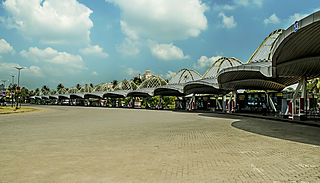
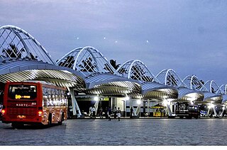
Vyttila Mobility Hub is an integrated transit terminal in the city of Kochi. It is designed as a converging point of various forms of public transportation, such as local and long-distance buses, metro rail and inland water transport. It is planned over an area of 37 acres (150,000 m2) in Vyttila, making it one of the largest bus termini in India.

Panampilly Nagar is a ward of Kochi, Kerala. It is an upscale area of downtown Kochi, with both commercial and residential developments. It is a busy upmarket residential area in Kadavanthra region just 1 km east of M.G Road, the center of Kochi city.
Kathrikadavu is a region in the city of Kochi, in the state of Kerala, India. It lies almost midway between the two major intersections (junctions) in Kochi, namely Kaloor and Kadavanthra. Kathrikadavu is mainly a residential area, though of late more and more commercial establishments are being set up here.
![Sahodharan Ayyappan after whom the road is named shoodr[?]-ayypp[?]-smaarkN-kocci.jpg](http://upload.wikimedia.org/wikipedia/commons/thumb/e/e8/%E0%B4%B8%E0%B4%B9%E0%B5%8B%E0%B4%A6%E0%B4%B0%E0%B5%BB-%E0%B4%85%E0%B4%AF%E0%B5%8D%E0%B4%AF%E0%B4%AA%E0%B5%8D%E0%B4%AA%E0%B5%BB-%E0%B4%B8%E0%B5%8D%E0%B4%AE%E0%B4%BE%E0%B4%B0%E0%B4%95%E0%B4%82-%E0%B4%95%E0%B5%8A%E0%B4%9A%E0%B5%8D%E0%B4%9A%E0%B4%BF.jpg/220px-%E0%B4%B8%E0%B4%B9%E0%B5%8B%E0%B4%A6%E0%B4%B0%E0%B5%BB-%E0%B4%85%E0%B4%AF%E0%B5%8D%E0%B4%AF%E0%B4%AA%E0%B5%8D%E0%B4%AA%E0%B5%BB-%E0%B4%B8%E0%B5%8D%E0%B4%AE%E0%B4%BE%E0%B4%B0%E0%B4%95%E0%B4%82-%E0%B4%95%E0%B5%8A%E0%B4%9A%E0%B5%8D%E0%B4%9A%E0%B4%BF.jpg)