Mahatma Gandhi Road (Kochi)

Last updated

Mahatma Gandhi Road

Location Kochi
Length4.5 km (2.8 mi)

Mahatma Gandhi Road, [1] popularly known as M. G. Road, is the main artery as well as the commercial high street of the city of Kochi, in the state of Kerala, India. The road lies north-south with its boundaries at the Venduruthy bridge, Thevara in the south, and the Madhava Pharmacy Junction in the north, where it intersects the Banerji Road. The road was earlier part of the NH 47A (Old Highway) and was later handed over to Kochi Municipal Corporation. The highway was earlier known as Seventy Feet road. The total distance of the road is 4.5 kilometres (2.8 mi).

Contents

View of M G Road Metro Station M G Road Metro Station.jpg
View of M G Road Metro Station
A view of M G Road from Padma Junction M G Road View.jpg
A view of M G Road from Padma Junction
M.G Road /S.A.Road junction at Medical Trust Hospital Ernakulam M.G Road Medical Trust Junction.jpg
M.G Road /S.A.Road junction at Medical Trust Hospital

M. G. Road is seen as the lifestyle district of the city of Kochi. On the sides of the road are the largest textile shops, as well as the largest jewellery outlets in the city. It was recently ranked one of the busiest and the most expensive in the state of Kerala.

Alongside of the road, several famous retail stores, hospitals, banks, leading hotels, malls and multiplexes are located. The famous Cochin Shipyard and Shenoys Theatre are also located in MG Road.

M.G.Road along with S.A.Road {another main arterial road} have the metro rail connectivity touching Ernakulam south railway station and Kadavanthra to reach Vytilla Hub,{ biggest transport hub of Kochi & Kerala State} will enhance the road's business potential and rapid passenger movement.

History

During days of British Raj, the present Kochi city was part of their princely states of British India. The oldest arterial road of the city was Chittoor Road built by Kochi Rajas connecting South Railway Station to Chittoor Temple at chittoor. This road does not connect to southern side of the city, particularly to Fort Kochi, the British quarter of Kochi. The British Resident felt need of another major road that connects to south. In the year 1920, Sir Robert Bristow - the Chief Engineer who conceived the new port of Kochi, announced his plans to create a new island from sea between Ernakulam Mainland and Fort Kochi island and transfer the existing port to the new island. He visioned the urgent need of new road connecting mainland and new port island for transferring materials and in future cargo requirements.

in 1923 plans for new road was finalized and work was started with Consort Queen Neythar Amma Parukutty providing land for the same. The new road was seventy feet in width and hence named as Seventy Feet road and opened to public in 1925. The road connected to newly formed port island- Willingdon through a bridge and merged with Chitoor Road near Kacheripady where the Central City offices of Kochi Kingdom were located.

Since then this road played an important role in the history of modern Cochin which several landmarks located this stretch. Today its one of the most important commercial road of the city and one of the most congested roads in the state.

In year 1972, the road was renamed as Mahatma Gandhi Road, in honour of father of the nation

Junctions

MG Road is considered to be CBD of Kochi city with several top retails stores and offices of leading corporate houses located on both the side of the road. The MG Road connects Vytilla Junction through S.A.Road, Marine Drive (through Banerjee Road) and Chittoor Road (at Kacheripady) at North to Thevara at south passing through 10 junctions.

It goes from Thevera to Willingdon Island via Venduthurthy Bridge and join with NH47A

Commercial

MG Road is a high end commercial street. The most important corporate house located in this stretch is Cochin Shipyard, one of the largest shipyards in India, located near Harbour side. Several top companies has their offices in this stretch and most of the banks in India maintains their regional offices or main branches in this road. The stretch also houses more than a dozen premium hotels as well as several famed jewellery brands. Some of the leading commercial landmarks are

Airline offices

Most of the airlines has their offices in Atlantis area. The area is famous for several leading travel agents, holiday companies and sight-seeing tour firms. The Air India Building located in Atlantis Junction is a landmark. Other major Airline/Tour offices are Sri Lankan, Singapore Airlines, Jet Airways, Saudi Arabian Airlines, Kingfisher Airlines, Sitas, ITC, GTL, SOTC, Cox & Kings etc.

Jewellery

Kochi is one of the most important gold shopping centres in India accounting to about 7 percent gold sales in the country Jewelries include Alapatt Heritage, Alappat Fashion jeweler, Alappat Arcade, House of Alappat, Francis Alukkas, Kalyan Jewelers, Bhima, Malabar Gold, Tanishq, Geeri pai, Thribhuvandas Bhimji Zaveri, Vanitha, Parakatt jewellers, Paul Alukkas.

Banks

Almost all national banks maintains its regional or main branches in this road. Regional offices of Central Bank of India, State Bank of India, State Bank of Travancore, ICICI Bank, Vijaya Bank, Dena Bank and Punjab National Bank etc. are located here. Branches of international banks like Standard Chartered, Citi Bank, HSBC, Oman Bank etc. are also located here

Hospitals

Education

See also

Related Research Articles

<span class="mw-page-title-main">Ernakulam district</span> District in Kerala, India

Ernakulam is one of the 14 districts in the Indian state of Kerala, and takes its name from the eponymous city division in Kochi. It is situated in the central part of the state, spans an area of about 2,924 square kilometres (1,129 sq mi), and is home to over 9% of Kerala's population. Its headquarters are located at Kakkanad. The district includes Kochi, also known as the commercial capital of Kerala, which is famous for its ancient Churches, Hindu temples, synagogues and mosques. The district includes the largest metropolitan region of the state: Greater Cochin. Ernakulam is the district that yields the most revenue and the largest number of industries in the state. Ernakulam is the third most populous district in Kerala, after Malappuram and Thiruvananthapuram. The district also hosts the highest number of international and domestic tourists in Kerala state.

<span class="mw-page-title-main">Edappally</span> Ward in Kerala, India

Edappally is a ward of Kochi, Kerala. The name is also used to refer to adjacent wards of Kalamassery and Thrikkakkara municipalities. Edappally is a major commercial centre as well as a prominent residential region. Edappally junction is one of the busiest junctions in the city.

<span class="mw-page-title-main">Ernakulam</span> Downtown in India

Ernakulam is the central business district of the city of Kochi, Kerala, India. It is the namesake of Ernakulam district. The eastern part of Kochi city is mainly known as Ernakulam, while the western part of it after the Venduruthy Bridge is called as Western Kochi. Many major establishments, including the Kerala High Court, the office of the Kochi Municipal Corporation and the Cochin Shipyard are situated in Ernakulam. It is also the most urbanized area in the city of Kochi.

<span class="mw-page-title-main">Cochin Port</span> A major port in India

Cochin Port or Kochi Port is a major port on the Arabian Sea – Laccadive Sea – Indian Ocean sea-route in the city of Kochi in Ernakulam district in the state of Kerala and is one of the largest ports in India. It is also the first transshipment port in India. The port lies on two islands in the Vembanadu Lake Willingdon Island and Vallarpadam, towards the Fort Kochi river mouth opening onto the Laccadive Sea. The International Container Transshipment Terminal (ICTT), part of the Cochin Port, is the largest container transshipment facility in India.

<span class="mw-page-title-main">Greater Cochin Development Authority</span> Statutory body overseeing Kochi city

Greater Cochin Development Authority (GCDA) is the statutory body overseeing the development of the city of Kochi in the state of Kerala, India. Headquartered at Kadavanthra, GCDA oversees the development of the major part of Greater Cochin area which consists of the Kochi Municipal Corporation, surrounding municipalities and 21 intervening panchayats covering an area of 632 km2.

<span class="mw-page-title-main">Ernakulam Town railway station</span> Railway station in Kerala, India

Ernakulam Town is one of the main railway stations in the city of Ernakulam, Kerala, India.

Kochi is a major port city in the Indian state of Kerala. The city is widely known as the commercial or economic capital of the state of Kerala.
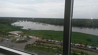
<span class="mw-page-title-main">Kadavanthra</span> Ward in Kerala, India

Kadavanthra is a ward in downtown Kochi, Kerala. It is bounded by the S.A Road to the east and the Giri Nagar canal in the west. Kadavanthra is a major commercial centre of Kochi, and a prime residential area. In recent years, the ward has undergone rapid development to become one of Kochi's highest-valued regions. The [[S.A Road] and Kaloor-Kadavanthra Road] are the Kadavanthra's main arterial roads, S.A.Road connects two icons Vyttila interchange in the west and M G Road in east. Kaloor-Kadavanthra arterial road connects Kaloor at the North and Kadavanthra downtown at South.

<span class="mw-page-title-main">Cheranallur</span> Suburb in Ernakulam, Kerala, India

Cheranallur or Cheranellore or Cheranelloor is a suburb of Kochi city in the state of Kerala, India and lies on the banks of the Periyar River. According to tradition, the area was named by its earlier inhabitants who found this place very fertile and beautiful. The name in its local language Malayalam means "Good Village of Cheras".

Thevara is a ward of Kochi, Kerala.

Nettoor is a region in the city of Kochi. It is around 5 km (3.1 mi) from Vytilla Junction and around 8 km (5.0 mi) from Ernakulam Junction Railway Station. Nettoor is located on Panangad Island and is a part of Maradu Municipality.
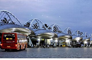
<span class="mw-page-title-main">Vyttila</span> Ward in Kerala, India

Vyttila, IPA:[ʋɐjt̺ːilɐ], is a ward of Kochi, Kerala. The Vyttila junction is one of the busiest as well as one of the largest intersections in Kerala. This node intersects the main north–south artery of the state of Kerala, namely, the Kochi Bypass, with three city roads of Kochi viz, the S. A. Road, the Vyttila-Petta Road, and the Thammanam Road.

<span class="mw-page-title-main">Kaloor</span> Neighbourhood in Ernakulam, Kerala, India

Kaloor is a downtown region in the city of Kochi, in the state of Kerala, India. It is two kilometres (1.2 mi) from the Ernakulam North Railway Station. Kaloor Junction is also the name of a major intersection in this part of the city, intersecting the two major arteries of downtown Kochi, namely Banerji Road and the Kaloor-Kadavanthra Road. The nearest major intersections are Palarivattom to the east and Lissie Junction to the west.

Sahodaran Ayyappan Road, popularly known as S.A Road is one of the most important and the second main arterial road of CBD Kochi city ; it is supposed to be the busiest and most congested road in the city of Kochi, which run in east-west direction and the shortest road connecting the two main iconic junctions in the city. The road connects the MG Road in west with Vyttila Junction & Hub in east and continues further as Tripunithura Road that connects to Tripunithura, hence termed as the back bone road of Kochi.

Park Avenue is a famous tree-lined road starting from the western end of Durbar Hall Road to Broadway in the city of Kochi, India. Two large parks, Subhash Bose Park and Indira Priyadarshini Park are situated along the road, hence the name. Several famous historical buildings are also located alongside the road. The road has more than 45 flowering trees planted on both sides, forming a thick canopy over the road. This 1.5 km stretch was considered to be a model road for the city and the road extends further north as Shanmugham Road.

Chittoor Road is one of the major arterial road in the city of Kochi, India. It is the oldest arterial road in the Ernakulam mainland city that connects Ernakulam south with Chittoor, Kochi island in Ernakulam north. The road runs in north–south direction parallel to coast, covering a distance of 8.2 kilometres (5.1 mi). The road was named after Chittoor temple as the road ends before the main gate of the temple.

This is a list of major areas and neighbourhoods in the city of Kochi by region. The eastern part of Kochi is mainly known as Ernakulam, while the western part of the city after the Venduruthy Bridge is called as Western Kochi.

<span class="mw-page-title-main">Panampilly Nagar</span> Neighborhood in Kochi, India

Panampilly Nagar is a ward of Kochi, Kerala. It is an upscale area of downtown Kochi, with both commercial and residential developments. It is a busy upmarket residential area in Kadavanthra region just 1 km east of M.G Road, the center of Kochi city.

Transport in Ernakulam district consists of various modes.

References

  1. "Kochi: M G Road, Kochi Tourist Places to Visit for Shopping". Archived from the original on 25 July 2008.