Sah, Mali

Last updated
Sah
Village
Mali adm location map.svg
Red pog.svg
Sah
Location in Mali
Coordinates: 15°37′33″N4°2′56″W / 15.62583°N 4.04889°W / 15.62583; -4.04889 Coordinates: 15°37′33″N4°2′56″W / 15.62583°N 4.04889°W / 15.62583; -4.04889
CountryFlag of Mali.svg  Mali
Region Mopti Region
Cercle Youwarou Cercle
Commune N'Dodjiga
Time zone GMT (UTC+0)

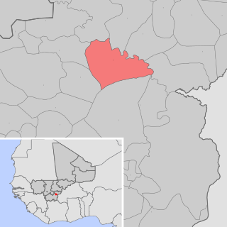
Sah (or Sa) is a village and seat of the commune of N'Dodjiga in the Cercle of Youwarou in the Mopti Region of southern-central Mali. [1] The village lies on the east (right) bank of the Bara-Issa, the smaller of the two branches of the Niger River that flow north out of Lake Débo.

NDodjiga Commune in Mopti Region, Mali

N'Dodjiga is a commune of the Cercle of Youwarou in the Mopti Region of Mali. The commune contains about 50 small villages. The main village (chef-lieu) is Sah. In 2009 the commune had a population of 22,326.

Youwarou Cercle Cercle in Mopti Region, Mali

Youwarou Cercle is an administrative subdivision of the Mopti Region of Mali. The administrative center (chef-lieu) is the town of Youwarou.

Mopti Region Region in Mali

Mopti is the fifth administrative region of Mali, covering 79,017 km2. Its capital is the city of Mopti. During the 2012 Northern Mali conflict, the frontier between Southern Mali which is controlled by the central government and the rebel-held North ran through Mopti Region.

The French explorer, René Caillié stopped at Sah in April 1828 on his journey by boat from Djenné to Timbuktu. He was surprised at the extent of the commercial activity at what was then an important port:

René Caillié French explorer

Auguste René Caillié was a French explorer and the first European to return alive from the town of Timbuktu.

Djenné Commune and town in Mopti Region, Mali

Djenné is a town and an urban commune in the Inland Niger Delta region of central Mali. The town is the administrative centre of the Djenné Cercle, one of the eight subdivisions of the Mopti Region. The commune includes ten of the surrounding villages and in 2009 had a population of 32,944.

Timbuktu City in Tombouctou Region, Mali

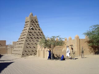
Timbuktu is an ancient city in Mali, situated 20 km (12 mi) north of the Niger River. The town is the capital of the Timbuktu Region, one of the eight administrative regions of Mali. It had a population of 54,453 in the 2009 census.

There were in the port of Sa from four to five hundred persons seamen and inhabitants who gazed at the flotilla. The port was covered with bales of merchandise, ready to be shipped on board the canoes. The commercial activity appeared astonishing. There was something in the appearance of the flotilla far more interesting than I could have expected to find in the interior of Africa. The bustle on every side almost made me fancy myself in a trading port of Europe. The largest vessels belong to Moors, who carry on the principal trade of the country: they form themselves into companies and employ their canoes in conveying merchandise to Timbuctoo, where they are paid their freight in salt or cowries. [2]

Nowadays, boats use the larger branch of the Niger River, the Issa-Ber, and the port of Sah sees very little activity. [3]

Related Research Articles

Kankan Sub-prefecture and town in Kankan Region, Guinea

Kankan (Mandingo: Kánkàn) is the largest city in Guinea in land area, and the third largest in population, with a population of 193,830 people as of 2014. The city is located on the Milo River in eastern Guinea and lying about 345 miles east of Conakry.

Araouane Village in Taoudénit Region, Mali

Araouane or Arawan is a small village in the Malian part of the vast Sahara Desert, lying 243 km (151 mi) north of Timbuktu on the caravan route to the salt-mining centre of Taoudenni. The village once served as an entrepôt in the trans-Saharan trade.

Kouroussa Sub-prefecture and town in Kankan Region, Guinea

Kouroussa or Kurussa is a town located in northeastern Guinea, and is the capital of Kouroussa Prefecture. As of 2014 it had a population of 39,611 people. A trade center and river port from at least the time of the Mali Empire, Kouroussa has long relied upon its position near the upstream limit of navigation of the Niger River to make it an important crossroads for people and goods moving between the Guinea coast and the states of the western Soudan and Niger River valley. The town and surrounding area is a center of Malinke culture, and is known for its Djembe drumming tradition.

Zangasso Commune and town in Sikasso Region, Mali

Zangasso is a small town and commune in the Cercle of Koutiala in the Sikasso Region of southern Mali. The commune covers an area of 452 square kilometers and includes 10 settlements. In the 2009 census it had a population of 19,925. The small town of Zangasso, the administrative centre (chef-lieu) of the commune, is 30 km southwest of Koutiala on the Route Nationale 11 that links Koutiala with Sikasso.

Doumanaba Commune and town in Sikasso Region, Mali

Doumanaba is a small town and rural commune in the Cercle of Sikasso in the Sikasso Region of southern Mali. The commune covers an area of 288 square kilometers and includes the town and seven villages. In the 2009 census it had a population of 15,105. The town of Doumanaba, the chef-lieu of the commune, is 49 km northwest of Sikasso.

Kouoro Commune and town in Sikasso Region, Mali

Kouoro is a small town and rural commune in the Cercle of Sikasso in the Sikasso Region of southern Mali. The commune covers an area of 472 square kilometers and includes the town and five villages. In the 2009 census it had a population of 11,315. The town of Kouoro, the chef-lieu of the commune, is 75 km north of Sikasso, on the RN11, the main road linking Sikasso and Koutiala. It is also about 30 km west of the border with Burkina Faso.

Bongosso Village in Sikasso Region, Mali

Bongosso is a village and seat (chef-lieu) of the commune of Koromo in the Cercle of Koutiala in the Sikasso Region of southern Mali. The village is 45 km northeast of Koutiala.

Sirakélé Village in Sikasso Region, Mali

Sirakélé is a village and seat of the commune of Songoua in the Cercle of Koutiala in the Sikasso Region of southern Mali. The village is 15 km north of Koutiala.

Baramba Village in Sikasso Region, Mali

Baramba is a village and administrative centre (chef-lieu) of the commune of Nampé in the Cercle of Koutiala in the Sikasso Region of southern Mali. The village is 25 km north of Koutiala.

Toguéré Coumbé Commune and village in Mopti Region, Mali

Toguéré Coumbé is a village and commune of the Cercle of Ténenkou in the Mopti Region of Mali. The commune contains 32 villages and in 2009 had a population of 27,057.

Farimaké Commune in Mopti Region, Mali

Farimaké is a commune of the Cercle of Youwarou in the Mopti Region of Mali. The local government is based in the village of Gathi-Loumbo. The commune covers an area of 3,148 km2. It is bounded to the west by the commune of Youwarou, to the north by the communes of Dianké, Léré and Alzounoub, to the east by the commune of Nampalari and to the south by the communes of Kareri, Toguéré Coumbé and Bimbere Tama. The commune lies to the west of the Issa-Ber, the larger of the two branches of the Niger River that flow out of Lake Débo. The commume contains 29 small villages and in 2009 had a population of 11,869. The largest ethnic group are the Fulani who make up more than 40 percent of the population.

Minignan Town, sub-prefecture, and commune in Denguélé, Ivory Coast

Minignan is a town in north-western Ivory Coast. It is a sub-prefecture of and the seat of Minignan Department. It is also a commune and the seat of Folon Region in Denguélé District.

Samatiguila Town, sub-prefecture, and commune in Denguélé, Ivory Coast

Samatiguila is a town in northwestern Ivory Coast. It is a sub-prefecture of and the seat of Samatiguila Department in Kabadougou Region, Denguélé District. Samatiguila is also a commune. It is located approximately 15 km north of Kimbirila-Sud, and 40 km north of Odienné, the nearest main town and the capital of the Denguélé District. Samatiguila is well-known among Ivorians for the large number of traders and bus companies that originate from the town but that operate all over Ivory Coast.

Tiémé Town, sub-prefecture, and commune in Denguélé, Ivory Coast

Tiémé is a town in northwestern Ivory Coast. It is a sub-prefecture and commune of Odienné Department in Kabadougou Region, Denguélé District. It is situated between two major towns of the Denguélé: Odienné is located approximately 20 kilometres (12 mi) west, and Madinani lies 28 kilometres (17 mi) east.

Tengréla Town, sub-prefecture, and commune in Savanes, Ivory Coast

Tengréla is a town in the far north of Ivory Coast. It is a sub-prefecture and the seat of Tengréla Department in Bagoué Region, Savanes District. Tengréla is also a commune.

Koloni Village in Sikasso Region, Mali

Koloni is a village and administrative centre (chef-lieu) of the commune of Niantaga in the Cercle of Koutiala in the Sikasso Region of southern Mali. The village is 45 km north-northeast of Koutiala.

Kabara, Mali Town in Tombouctou Region, Mali

Kabara is a small town in Mali on the Niger River, the port for Timbuktu. It is 8 km (5 mi) to the south of Timbuktu and is connected to an arm of the Niger River by a 3 km (2 mi) canal. The town has at times in the past been linked to Timbuktu by an extension of the canal. However, silting and lower water levels in recent years have made the extension canal unusable and the Kabara port usable only during the high water seasons.

References

  1. Communes de la Région de Mopti (PDF) (in French), Ministère de l’administration territoriale et des collectivités locales, République du Mali, archived from the original (PDF) on 2012-09-19.
  2. Caillié, René (1830), Travels through Central Africa to Timbuctoo; and across the Great Desert, to Morocco, performed in the years 1824-1828. Volume 2, London: Colburn & Bentley, p. 27.
  3. Viguier, Pierre (2008), Sur les Traces de René Caillié: Le Mali de 1828 Revisité, Versailles, France: Quae, pp. 112–113, ISBN   978-2-7592-0271-3 .