
Narragansett Bay is a bay and estuary on the north side of Rhode Island Sound covering 147 square miles (380 km2), 120.5 square miles (312 km2) of which is in Rhode Island. The bay forms New England's largest estuary, which functions as an expansive natural harbor and includes a small archipelago. Small parts of the bay extend into Massachusetts.

Aquidneck Island, also known as Rhode Island, is an island in Narragansett Bay in the state of Rhode Island. The total land area is 97.9 km2 (37.8 sq mi), which makes it the largest island in the bay. The 2020 United States Census reported its population as 60,109. The state of Rhode Island is named after the island; the United States Board on Geographic Names recognizes Rhode Island as the name for the island, although it is widely referred to as Aquidneck Island in the state and by the island's residents.

A swing bridge is a movable bridge that has as its primary structural support a vertical locating pin and support ring, usually at or near to its center of gravity, about which the swing span can then pivot horizontally as shown in the animated illustration to the right. Small swing bridges as found over canals may be pivoted only at one end, opening as would a gate, but require substantial underground structure to support the pivot.

A moveable bridge, or movable bridge, is a bridge that moves to allow passage for boats or barges. In American English, the term is synonymous with drawbridge, and the latter is the common term, but drawbridge can be limited to the narrower, historical definition used in some other forms of English, in which drawbridge refers to only a specific type of moveable bridge often found in castles.
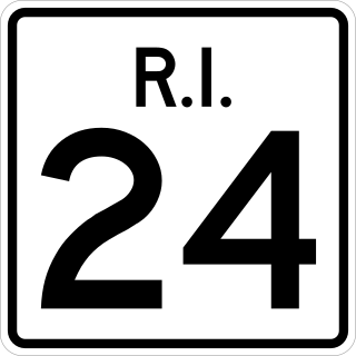
Route 24 is a limited-access state highway in the U.S. state of Rhode Island. It runs approximately 8 miles (13 km) from Route 114 in Portsmouth to Massachusetts Route 24 in Fall River, Massachusetts. Route 24 is the primary freeway access for the two towns in the southeastern corner of the state, Tiverton and Little Compton. Though on the mainland, they are isolated from the rest of the state by an arm of the Narragansett Bay. Because of this, the main freeway connection to Providence involves using Rhode Island Route 24, Massachusetts Route 24, and Interstate 195.

The Sakonnet River is a tidal strait in the state of Rhode Island which flows approximately 14 miles between Mount Hope Bay and Rhode Island Sound. It separates Aquidneck Island from the eastern portion of Newport County.
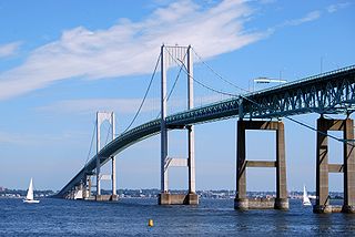
The Claiborne Pell Bridge, commonly known as the Newport Bridge, is a suspension bridge operated by the Rhode Island Turnpike and Bridge Authority that spans the East Passage of the Narragansett Bay in Rhode Island. The bridge, part of RI 138, connects the city of Newport on Aquidneck Island and the Town of Jamestown on Conanicut Island, and is named for longtime Rhode Island U.S. senator Claiborne Pell who lived in Newport. The Pell Bridge is in turn connected to the mainland by the Jamestown Verrazzano Bridge.
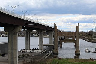
The Sakonnet River Bridge is a four-lane bridge spanning the Sakonnet River in eastern Rhode Island. The bridge carries RI 24 and RI 138 between the communities of Portsmouth and Tiverton, Rhode Island. The current bridge is a box girder bridge that opened in 2012 at a cost of $120 million (USD). The previous bridge was a truss bridge that was built in 1956 and demolished in 2012 due to structural deficiencies. The truss bridge had previously served as a replacement for the Stone Bridge, about 0.8 miles (1.3 km) to the south.

The New York, Providence and Boston Railroad, normally called the Stonington Line, was a major part of the New York, New Haven and Hartford Railroad between New London, Connecticut and Providence, Rhode Island. It is now part of Amtrak's high-speed Northeast Corridor.

The Quincy Rail Bridge is a truss bridge that carries a rail line across the Mississippi River between West Quincy, Missouri, and Quincy, Illinois, USA. It was originally constructed in 1868 for the Chicago, Burlington and Quincy Railroad, a predecessor of BNSF Railway.

The La Crosse Rail Bridge is a swing bridge that spans the Mississippi River between La Crescent, Minnesota and La Crosse, Wisconsin. The first bridge in this location initially was designed and ready to build by June 1876, and was completed in November 1876 by the Milwaukee and St. Paul Railway, a predecessor of the Chicago, Milwaukee, St. Paul and Pacific Railroad. It was later replaced in 1902. It is at the Western end of the Canadian Pacific Railway Tomah Subdivision. Amtrak's Empire Builder crosses this bridge.

The East Junction Branch is a historic railroad line owned and operated by the Providence and Worcester Railroad in the U.S. state of Rhode Island and by the Massachusetts Bay Transportation Authority in Massachusetts. The line runs from the P&W's East Providence Branch in East Providence, Rhode Island, northeast to Amtrak's Shore Line at East Junction in Attleboro, Massachusetts, along a former New York, New Haven and Hartford Railroad line. In Massachusetts, CSX Transportation operates local freight service via trackage rights, which it also has on the Shore Line north towards Boston. The Massachusetts Coastal Railroad and the MBTA commuter rail have operating rights in Massachusetts; however, neither have ever run trains on the branch.
Kingston is a historic railroad station located on the Northeast Corridor in the village of West Kingston, in the town of South Kingstown, Rhode Island. It was built at this location in 1875 by the New York, Providence and Boston Railroad, replacing earlier stations dating back to the opening of the line in 1837. Current rail services consist of Northeast Regional trains in each direction, most of which stop at the station. Historically Kingston provided commuter rail service to Providence and Boston via Amtrak's commuter rail services. The MBTA is looking at extending their commuter service with the Providence/Stoughton Line.

The Newport and Narragansett Bay Railroad is a heritage railroad that operates on Aquidneck Island, Rhode Island. It was formed in 2014-15 from the merger of the for-profit Newport Dinner Train and the nonprofit Old Colony and Newport Scenic Railway.

Mount Hope Bay is a tidal estuary located at the mouth of the Taunton River on the Massachusetts and Rhode Island border. It is an arm of Narragansett Bay. The bay is named after Mount Hope, a small hill located on its western shore in what is now Bristol, Rhode Island. It flows into the East Passage of Narragansett Bay and also the Sakonnet River. Mount Hope Bay has played an important role to the history of the area, from pre-colonial times to the present. While many years of sewage and industrial pollution have severely degraded the quality of the shallow waters of the bay, there are currently major efforts underway to clean up and restore it.

The Narragansett Pier Railroad was a railroad in southern Rhode Island, running 8 miles (13 km) from West Kingston to Narragansett Pier. It was built by the Hazard Family of Rhode Island to connect their textile mills in Peace Dale and Wakefield to the New York, Providence and Boston Railroad at Kingston Station as well as to ocean-going steamboats at Narragansett Pier. Passenger service ran on the line from 1876 to 1952; the line continued freight operation as a Class III railroad until 1981. Most of the right-of-way has been converted to the William C. O'Neill Bike Path.
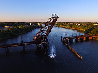
The Crook Point Bascule Bridge is a defunct Scherzer rolling lift railway bridge which spans the Seekonk River, connecting the city of Providence, Rhode Island, to the city of East Providence. Stuck in the open position since its abandonment in 1976, it is known to nearby residents as the "Stuck-Up Bridge" and has become somewhat of a local icon of urban decay.

India Point Railroad Bridge was a swing bridge which spanned the Seekonk River, connecting the City of Providence, Rhode Island at India Point to the City of East Providence at Watchemoket. It was last used in 1974, and the swing span was removed in 2001 leaving only two fixed truss spans.

The East Providence Branch is a railroad line in Rhode Island and Massachusetts, in the United States. It connects Valley Falls, Rhode Island, to East Providence, Rhode Island, via South Attleboro, Massachusetts, and Pawtucket, Rhode Island. The branch was originally built by the Providence and Worcester Railroad in 1874, connecting its main line to a coal dock in East Providence. The final 1.41 miles (2.27 km) of the line were formally abandoned in 2006.


