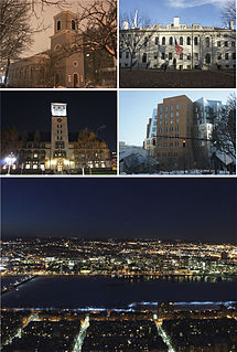
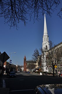
Central Square is an area in Cambridge, Massachusetts centered on the junction of Massachusetts Avenue, Prospect Street and Western Avenue. Lafayette Square, formed by the junction of Massachusetts Avenue, Columbia Street, Sidney Street and Main Street, is also considered a part of the Central Square area. Harvard Square is to the northwest along Massachusetts Avenue, Inman Square is to the north along Prospect Street and Kendall Square is to the east along Main Street. The section of Central Square along Massachusetts Avenue between Clinton Street and Main Street is designated the Central Square Historic District, and was added to the National Register of Historic Places in 1990.

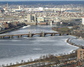
Cambridgeport is one of the neighborhoods of Cambridge, Massachusetts. It is bounded by Massachusetts Avenue, the Charles River, the Grand Junction Railroad, and River Street. The neighborhood contains predominantly residential homes, many of the triple decker style common in New England. Central Square, at the northernmost part of Cambridgeport, is an active commercial district and transportation hub, and University Park is a collection of renovated or recently constructed office and apartment buildings. The neighborhood also includes Fort Washington Park, several MIT buildings, and Magazine Beach.

The Margaret Fuller House was the birthplace and childhood home of American transcendentalist Margaret Fuller (1810–1850). It is located at 71 Cherry Street, in the Old Cambridgeport Historic District area of Cambridge, Massachusetts, in the neighborhood now called "Area 4" or "The Port". The house is now a National Historic Landmark.

The Kenilworth Avenue Historic District is a historic district in the northwestern portion of Dayton, Ohio, United States. Composed largely of houses constructed after the Great Flood of 1913, the district features examples of several prominent architectural styles, and it has received both local and federal recognition.
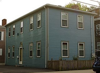
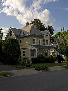
The Asa Ellis House is an historic house located at 158 Auburn Street, Cambridge, Massachusetts.

The Upper Magazine Street Historic District is a historic district encompassing a well-preserved stretch of mid-19th century housing in the Cambridgeport neighborhood of Cambridge, Massachusetts. It includes two blocks of Magazine Street, between Upton and William Streets, and one block of William Street, between Magazine and Pearl Streets. The properties in the district include a diversity of architectural styles popular between the 1840s and 1880s.
The Old Cambridge Historic District is a historic district encompassing a residential neighborhood of Cambridge, Massachusetts that dates to colonial times. It is located just west of Harvard Square, and includes all of the properties on Brattle Street west of Mason Street to Fresh Pond Parkway, all of the properties on Mason Street and Elmwood Avenue, and nearby properties on Craigie Street. The district includes five National Historic Landmarks: Elmwood, the Reginald A. Daly House, the Oliver Hastings House, the Mary Fiske Stoughton House, and the Longfellow House–Washington's Headquarters National Historic Site, as well as several other houses listed separately on the National Register. The district follows the general route of the Watertown Path, an early colonial road that supposedly followed a Native American trail. This portion of the way became known as Tory Row during the American Revolution, because many of the fine mansions lining it were owned by Loyalists. In the 19th and early 20th centuries it continued by a fashionable location, and now features a number of architecturally significant buildings. It includes 215 contributing buildings and one other contributing sites over an area of 52 acres (21 ha). One included building is the Cambridge Historical Society's offices, which are in the NRHP-listed Hooper-Lee Nichols House, located at 159 Brattle Street.

The Old Cambridgeport Historic District is a historic district along Cherry, Harvard and Washington Streets in Cambridge, Massachusetts. It contains some of the oldest surviving houses north of Massachusetts Avenue in the Cambridgeport section of the city. It includes the entire block of Cherry Street between Harvard and Washington Streets, as well as a few buildings on those two streets. The oldest houses are the Samuel Fay House and the Margaret Fuller House.
The Summer Street Historic District encompasses a fashionable 19th-century residential area of Adams, Massachusetts. Centered on the junction of Summer Street with Center and Orchard Streets, it extends mainly north along Summer Street, and includes fine examples of Greek Revival, Late Victorian, and Federal style architecture. It was listed on the National Register of Historic Places in 1985.

The Quadrangle–Mattoon Street Historic District is a historic district in Springfield, Massachusetts, bounded by Chestnut Street to the West; State Street to the South; and includes properties on Mattoon, Salem, Edwards and Elliot Streets. Located in the Metro Center, the Quadrangle–Mattoon Street Historic District is one of the few neighborhoods in the Knowledge Corridor lined with historic, restored red-brick Victorian row houses on both sides, covered by tree canopies.
The Beverly Center Business District encompasses much of the historic 19th century commercial heart of Beverly, Massachusetts. Centered on Cabot and Church Streets between Central Street and the Beverly Common, its architecture reflects the city's growth over 150 years. The district was added to the National Register of Historic Places in 1984.

The Federal Street District is a residential and civic historic district in Salem, Massachusetts. It is an expansion of an earlier listing of the Essex County Court Buildings on the National Register of Historic Places in 1976. In addition to the former county court buildings included in the earlier listing, the district expansion in 1983 encompasses the entire block of Federal Street between Washington and North Streets. It includes buildings from 32 to 65 Federal Street, as well as the Tabernacle Church at 50 Washington Street.

Highland Heights–Stevens' Subdivision Historic District is a residential historic district located in Highland Park, Michigan along five east-west streets: Farrand Park, McLean Street, Colorado Street, Rhode Island Street, and Massachusetts Street, between Woodward Avenue on the west and Oakland Avenue on the east. The district was listed on the National Register of Historic Places in 1988.

The West End South Historic District encompasses a neighborhood of mid 19th to early 20th century residential architecture in western Hartford, Connecticut and eastern West Hartford, Connecticut. Roughly bounded by Prospect and South Whitney Streets, West Boulevard, and Farmington Avenue, the area includes a large number of Colonial Revival and Queen Anne houses, as well as numerous buildings in other period styles, with only a small number of losses. It was listed on the National Register of Historic Places in 1985.

The Dwight Street Historic District is an irregularly shaped 135-acre (55 ha) historic district in New Haven, Connecticut. The district is located immediately west of the center of Downtown New Haven and is generally bounded by Elm Street on the north, Park Street on the east, North Frontage Road on the south, and Sherman Avenue on the west. It contains one of the city's highest concentrations of well-preserved 19th and early 20th-century residential architecture, much of which was developed for the working classes in the city's factories. It was listed on the National Register of Historic Places in 1983. The historic district includes most of the Dwight neighborhood and several blocks of the northeast corner of the West River neighborhood.

The Laurel Hill Historic District is a predominantly residential historic district south of downtown Norwich, Connecticut. The district was added to the National Register of Historic Places on October 26, 1987. It extends south from the Shetucket River along Laurel Hill Avenue, River Avenue, and Spruce Street. This area was developed as a residential district beginning in 1850, and includes a significant number of well-preserved Italianate and Gothic Revival houses.

Mount Vernon Triangle is a neighborhood and community improvement district in the northwest quadrant of Washington, D.C. Originally a working-class neighborhood established in the 19th century, present-day Mount Vernon Triangle experienced a decline in the mid-20th century as it transitioned from residential to commercial and industrial use. The neighborhood has undergone significant and rapid redevelopment in the 21st century. It now consists mostly of high-rise condominium, apartment and office buildings. Several historic buildings in the neighborhood have been preserved and are listed on the National Register of Historic Places. Mount Vernon Triangle is now considered a good example of urban planning and a walkable neighborhood.

The Newlands Historic District in Reno, Nevada is a historic district on the bluffs south of the Truckee River which was listed on the National Register of Historic Places in 2016.

The West End North Historic District encompasses a neighborhood of late 19th and early 20th century residential architecture in western Hartford, Connecticut and eastern West Hartford, Connecticut. Roughly bounded by Prospect, Elizabeth, and Lorraine Streets and Farmington Avenue, the area includes a large number of Colonial Revival and Queen Anne houses, as well as numerous buildings in other period styles, with only a small number of losses. It was listed on the National Register of Historic Places in 1985.

The Pomeroy Terrace Historic District is a historic district on the east side of downtown Northampton, Massachusetts. Located south of Bridge Street east of the main railroad right-of-way, it was one of the city's most desirable residential neighborhoods of the 19th century, retaining many fine examples of residential architecture from that period. It was listed on the National Register of Historic Places in 2018.