Salt River Township | |
|---|---|
 | |
| Coordinates: 40°09′34″N092°25′07″W / 40.15944°N 92.41861°W | |
| Country | United States |
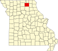
| State | Missouri |
| County | Adair |
| Area | |
• Total | 56.16 sq mi (145.45 km2) |
| • Land | 56.15 sq mi (145.43 km2) |
| • Water | 0.0077 sq mi (0.02 km2) 0.02% |
| Elevation | 873 ft (266 m) |
| Population (2010) | |
• Total | 1,043 |
| • Density | 19/sq mi (7.2/km2) |
| FIPS code | 29-65540 [2] |
| GNIS feature ID | 0766217 |
Salt River Township is one of ten townships in Adair County, Missouri, United States. As of the 2010 census, its population was 1,043. [3] Salt River Township was named from one its principal streams. [4]