
Apulia, also known by its Italian name Puglia, is a region of Italy, located in the southern peninsular section of the country, bordering the Adriatic Sea to the east, the Strait of Otranto and Ionian Sea to the southeast and the Gulf of Taranto to the south. The region comprises 19,345 square kilometers (7,469 sq mi), and its population is about four million people. It is bordered by the other Italian regions of Molise to the north, Campania to the west, and Basilicata to the southwest. The regional capital is Bari.

Molise is a region of Southern Italy. Until 1963, it formed part of the region of Abruzzi e Molise together with Abruzzo. The split, which did not become effective until 1970, makes Molise the newest region in Italy. Covering 4,438 square kilometres (1,714 sq mi), it is the second smallest region in the country, after the Aosta Valley, and has a population of 313,348.

The province of Campobasso is a province in the Molise region of Italy. Its capital is the city of Campobasso. It covers an area of c. 2,941 square kilometres (1,136 sq mi) and has a total population of 223,871 (2017). There are 84 comuni in the province.

Monteleone di Puglia is a hill town and comune of the province of Foggia in the Apulia region of south-eastern Italy.
Montemitro is a small town and comune in the province of Campobasso in the Molise region of Italy, near the Trigno river.

San Felice del Molise is a small town and comune in the province of Campobasso in the Molise region of Italy, near the Trigno river.
Accadia is a town and comune in the province of Foggia in the Apulia region of southeast Italy. Until the mid-20th century it was just within the eastern frontier of the region of Campania in the province of Avellino.

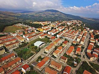
Anzano di Puglia is a small town and comune in the province of Foggia and region of Apulia in southeast Italy. It rises 760 metres (2,490 ft) above sea level.

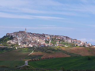
Sant'Agata di Puglia is a town and comune in the province of Foggia in the Apulia region of southeast Italy.

Serracapriola is an Italian town of 4,039 inhabitants, located in the province of Foggia, Apulia. It is part of the Gargano National Park, and it is placed at the border between Apulia and Molise, on a hill 270 meters tall.

Vico del Gargano is a village and comune in the province of Foggia in the Apulia region of southeast Italy. Called the "Village of Love", it is part of the Gargano National Park and the Mountain Community of Gargano.
Bonefro is a comune (municipality) in the Province of Campobasso in the Italian region Molise, located about 25 kilometres (16 mi) northeast of Campobasso.

Colletorto is a comune (municipality) of approximately 1,786 inhabitants in the province of Campobasso, in the Italian region of Molise, located about 45 kilometres (28 mi) from the capital of the region Campobasso and 40 kilometres (25 mi) from Termoli (CB), sea town with port, railway and highway A14.
Montenero di Bisaccia is a small hill top town and comune (municipality). It is in the Province of Campobasso, which is in the region of Molise, in Italy. It is about 10 kilometres (6 mi) inland from the coast, and about 45 kilometres (28 mi) north of Campobasso. The nearest large town and airport is Pescara. Montenero di Bisaccia borders the following municipalities: Cupello, Guglionesi, Lentella, Mafalda, Montecilfone, Palata, Petacciato, San Felice del Molise, San Salvo, Tavenna.
Santa Croce di Magliano is a comune (municipality) in the Province of Campobasso in the Italian region Molise, located about 30 kilometres (19 mi) northeast of Campobasso. The settlement was formerly inhabited by an Arbëreshë community, who have since assimilated.
Sant'Elia a Pianisi is a comune (municipality) in the Province of Campobasso in the Italian region Molise, located about 20 kilometres (12 mi) northeast of Campobasso. As of 31 December 2004, it had a population of 2,178 and an area of 67.8 square kilometres (26.2 sq mi).
Two earthquakes hit the Italian regions of Molise and Apulia on 31 October at 10:32:58 (UTC) and 1 November at 15:09:00 (UTC). The shocks had magnitudes of 5.9 and 5.8 respectively. Most of the victims were killed and injured when a school collapsed in the town of San Giuliano di Puglia: 26 of the 51 schoolchildren died, together with one of their teachers. In particular, none of the nine children in the school's 4th Year survived.

The Metropolitan City of Bari is a metropolitan city in the Apulia region of Italy. Its capital is the city of Bari. It replaced the province of Bari and includes the city of Bari and some forty other comuni. It was first created by the reform of local authorities and then established by the Law 56/2014. It has been operative since January 1, 2015.
Banca Popolare di Puglia e Basilicata S.C.p.A. is an Italian cooperative bank based in Altamura, in the province of Bari, Apulia region.
Banca Popolare Pugliese S.C.p.A. (BPP) is an Italian cooperative bank based in Parabita and Matino, in the province of Lecce, Apulia region.


