San Massimo

Last updated • 2 min readFrom Wikipedia, The Free Encyclopedia
San Massimo
Comune di San Massimo
Location of San Massimo
San Massimo
Italy provincial location map 2016.svg
Red pog.svg
San Massimo
Location of San Massimo in Italy
Italy Molise location map.svg
Red pog.svg
San Massimo
San Massimo (Molise)
Coordinates: 41°29′N14°25′E / 41.483°N 14.417°E / 41.483; 14.417
Country Italy
Region Molise
Province Province of Campobasso (CB)
Frazioni Campitello Matese
Area
[1]
  Total27.6 km2 (10.7 sq mi)
Population
 (2018-01-01) [2]
  Total754
  Density27/km2 (71/sq mi)
Time zone UTC+1 (CET)
  Summer (DST) UTC+2 (CEST)
Postal code
86027
Dialing code 0874

San Massimo is a comune (municipality) in the Province of Campobasso in the Italian region Molise, located about 25 kilometres (16 mi) southwest of Campobasso, comprising 27.6 square kilometres (10.7 sq mi). [3]

Contents

As of 2017, San Massimo has a population of 754. [3]

Etymology

San Massimo is named for Saint Maximus, the 3rd century Bishop of Nola whose followers fled to the region near San Massimo during the Decian Persecution of Roman Christians in 251 CE. [4]

History

From c. 500 BCE until the Roman era, the territory of modern-day San Massimo was controlled by the Samnites, an ethnic group composed of a fusion of indigenous people and iron-age era migrants from Greece and other parts of Europe. [4] [5] In a series of wars, known as the Samnite Wars, Rome conquered the region. Following the collapse of the Western Roman Empire, Germanic Lombards occupied the area, before they in turn were conquered by the Normans. Norman nobleman, and their descendants, first administered the region as the County of Apulia and Calabria, which later joined other Norman counties to make up the Kingdom of Sicily in 1130. When Sicily seceded in the Vespers of 1282, the mainland possessions of the Normans, including San Massimo, became the Kingdom of Naples.

The first reference to San Massimo, dating to 1113 CE, occurs in the locative surname of a Norman nobleman, De Sancto Maximo. At the time, San Massimo likely was a feudal estate, composed of a castle, the remains of which can be seen today, surrounded by farmland. [6] The Church of Santa Maria delle Fratte was erected in the 12th century, and rebuilt on several occasions after devastating earthquakes that nearly leveled San Massimo in 1456 and 1805. [6]

In 1815 the merger of the Kingdom of Naples, which included San Massimo, and that of Sicily led to the formation of the short lived Kingdom of Two Sicilies. In 1860, the Sardinian forces of Giuseppe Garibaldi conquered the region, leading to the formation of the Kingdom of Italy.

Many residents of San Massimo fought and died for Italy in the First World War, as commemorated in the city center by the "Monument to the Fallen of the Great War," opened in 1920.

Throughout the 19th and 20th century, a significant portion of the population emigrated overseas, especially to Canada, as well as to urban centers within Italy. [7]

Geography

San Massimo is nestled in the Matese Mountains, near Monte Miletto, the highest mountain in the region at 2,050 m. It also includes substantial amounts of lowland woods, consisting of chestnut and conifer groves, and agricultural land.

The municipality of San Massimo contains the frazione (subdivision) Campitello Matese, located at 1,450 metres (4,760 ft) above sea level, which shares its name with its ski resort, one of the foremost in Central and Southern Italy.

San Massimo borders the following municipalities: Bojano, Cantalupo nel Sannio, Macchiagodena, Roccamandolfi, San Gregorio Matese.

Notable people

Raffaele Gioia, painter

Related Research Articles

<span class="mw-page-title-main">Campobasso</span> City in Molise, Italy

Campobasso is a city and comune in southern Italy, the capital of the region of Molise and of the province of Campobasso. It is located in the high basin of the Biferno river, surrounded by Sannio and Matese mountains.

<span class="mw-page-title-main">Province of Caserta</span> Province of Italy

The province of Caserta is a province in the Campania region of Italy. Its capital is the city of Caserta, situated about 36 kilometres (22 mi) by road north of Naples. The province has an area of 2,651.35 square kilometres (1,023.69 sq mi), and had a total population of 924,414 in 2016. The Palace of Caserta is located near to the city, a former royal residence which was constructed for the Bourbon kings of Naples. It was the largest palace and one of the largest buildings erected in Europe during the 18th century. In 1997, the palace was designated a UNESCO World Heritage Site.

<span class="mw-page-title-main">Province of Campobasso</span> Province of Italy

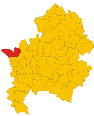
The province of Campobasso is a province in the Molise region of Italy. Its capital is the city of Campobasso. It covers an area of c. 2,941 square kilometres (1,136 sq mi) and has a total population of 223,871 (2017). There are 84 comuni in the province.

<span class="mw-page-title-main">Mirabello Sannitico</span> Comune in Molise, Italy

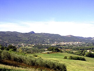
Mirabello Sannitico is a small town in the province of Campobasso, Molise, southern Italy. The population is about 2,100 inhabitants. It has an agrarian-based culture and history, dating back to at least the 12th century. Nearby towns include Campobasso to the northwest and Vinchiaturo to the southwest. The Tappino River flows on either side of the town on the north and south.

<span class="mw-page-title-main">Macchia Valfortore</span> Comune in Molise, Italy

Macchia Valfortore is a town and comune in the Province of Campobasso, Molise, southern Italy.

<span class="mw-page-title-main">Agnone</span> Comune in Molise, Italy

Agnone is a comune in the province of Isernia, in the Molise region of southern Italy, some 53 km (33 mi) northwest of Campobasso. Agnone is known for the manufacture of bells by the Marinelli Bell Foundry. The town of Agnone proper is complemented with other populated centers like Fontesambuco, Villa Canale and Rigaini.

Terra di Lavoro is the name of a historical region of Southern Italy. It corresponds roughly to the modern southern Lazio and northern Campania and upper north west and west border area of Molise regions of Italy.

<span class="mw-page-title-main">Piedimonte Matese</span> Comune in Campania, Italy

Piedimonte Matese is a comune (municipality) in the Province of Caserta in the Italian region of Campania, located about 82 km north of Naples and about 40 km north of Caserta.

<span class="mw-page-title-main">Morcone</span> Place in Campania, Italy


Morcone is a comune (municipality) in the Province of Benevento in the Italian region Campania, located about 70 km northeast of Naples and about 25 km northwest of Benevento. The villages (Contrade) of Morcone include: Canepino, Cuffiano, Coste, Torre, Fuschi, Piana.

<span class="mw-page-title-main">Pietraroja</span> Place in Campania, Italy

Pietraroja is a mountain comune (municipality) in the province of Benevento in Campania, southern Italy. It is approximately 50 km by car from Benevento, in direction north-west, 83 km from Naples in direction north-east and approximately 223 km from Rome in direction south-east.

Campochiaro is a comune (municipality) in the Province of Campobasso in the Italian region Molise, located about 20 kilometres (12 mi) southwest of Campobasso.

Colle d'Anchise is a comune (municipality) in the Province of Campobasso in the Italian region Molise, located about 14 kilometres (9 mi) southwest of Campobasso.

<span class="mw-page-title-main">Guardialfiera</span> Comune in Molise, Italy

Guardialfiera is a comune (municipality) in the Province of Campobasso in the Italian region Molise, located about 30 kilometres (19 mi) northeast of Campobasso. It sits on a hilltop overlooking Lake Guardialfiera, which was created as a result of the damming of the Biferno river.

San Polo Matese is a comune (municipality) in the Province of Campobasso in the Italian region Molise, located about 20 kilometres (12 mi) southwest of Campobasso.

<span class="mw-page-title-main">Frosolone</span> Comune in Molise, Italy

Frosolone is a comune (municipality) in the Province of Isernia in the Italian region Molise, located about 20 kilometres (12 mi) west of Campobasso and about 20 kilometres (12 mi) east of Isernia. It is one of I Borghi più belli d'Italia. Frosolone is known historically for the production of blades, including knives and scissors, and is home to a museum dedicated to the craft.

<span class="mw-page-title-main">Pizzone, Molise</span> Comune in Molise, Italy

Pizzone is a comune (municipality) in the Province of Isernia in the Italian region Molise, about 50 kilometres (31 mi) west of Campobasso and about 20 kilometres (12 mi) northwest of Isernia near the Monti della Meta chain.

Poggio Sannita is a comune (municipality) in the Province of Isernia in the Italian region Molise, located about 30 kilometres (19 mi) northwest of Campobasso and about 25 kilometres (16 mi) northeast of Isernia. Poggio Sannita is on a promontory surrounded by the Verrino and Sente rivers, both mostly torrential in character, especially the latter, which dries up completely during the summer.

<span class="mw-page-title-main">Roccamandolfi</span> Comune in Molise, Italy

Roccamandolfi is a comune (municipality) in the Province of Isernia in the Italian region Molise, located about 25 kilometres (16 mi) southwest of Campobasso and about 15 kilometres (9 mi) southeast of Isernia.

<span class="mw-page-title-main">Matese</span> Chain of mountains in southern Italy

The Matese is a chain of mountains in southern Apennines, southern Italy.

<span class="mw-page-title-main">Campitello Matese</span> Frazione in Molise, Italy

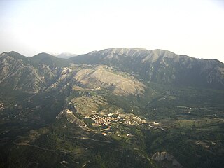
Campitello Matese is an Italian civil parish (frazione) and ski resort, part of the municipality of San Massimo in the province of Campobasso, Molise region.

References

  1. "Superficie di Comuni Province e Regioni italiane al 9 ottobre 2011". Italian National Institute of Statistics. Retrieved 16 March 2019.
  2. "Popolazione Residente al 1° Gennaio 2018". Italian National Institute of Statistics. Retrieved 16 March 2019.
  3. 1 2 "Presentazione | Comune di San Massimo". www.comune.sanmassimo.cb.it (in Italian). Retrieved 2017-03-28.
  4. 1 2 "Nome e origini | Comune di San Massimo". www.comune.sanmassimo.cb.it (in Italian). Retrieved 2017-03-28.
  5. Monaco, Davide. "SAMNITES THE PEOPLE". www.sanniti.info. Retrieved 2017-03-28.
  6. 1 2 "Chiese e monumenti | Comune di San Massimo". www.comune.sanmassimo.cb.it (in Italian). Retrieved 2017-03-28.
  7. "Molise Region - Italy". www.enchantingitaly.com. Retrieved 2017-03-28.

Commons-logo.svg Media related to San Massimo (Italy) at Wikimedia Commons