
Campobasso is a city and comune in southern Italy, the capital of the region of Molise and of the province of Campobasso. It is located in the high basin of the Biferno river, surrounded by Sannio and Matese mountains.

Molise is a region of Southern Italy. Until 1963, it formed part of the region of Abruzzi e Molise together with Abruzzo. The split, which did not become effective until 1970, makes Molise the newest region in Italy. Covering 4,438 square kilometres (1,714 sq mi), it is the second smallest region in the country, after the Aosta Valley, and has a population of 313,348.
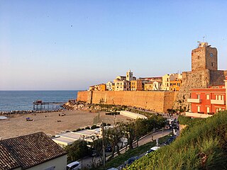
Termoli is a comune (municipality) on the south Adriatic coast of Italy, in the province of Campobasso, region of Molise. It has a population of around 32,000, having expanded quickly after World War II, and it is a local resort town known for its beaches and old fortifications. Once it was known only as a fishing port, but in the new millennium it is a favourite resort for Italian families. In Termoli we can find the only port of the region. There is also a strong competition with the province, Campobasso, in fact some of the “termolesi” like to say that Termoli is province-less

The province of Campobasso is a province in the Molise region of Italy. Its capital is the city of Campobasso. It covers an area of c. 2,941 square kilometres (1,136 sq mi) and has a total population of 223,871 (2017). There are 84 comuni in the province.

Guglionesi is a town and comune in Molise, southern Italy, about 50 kilometres (31 mi) from Campobasso.

Campomarino is an Arbëreshë comune in the Province of Campobasso, in the Italian region Molise, located about 50 kilometres (31 mi) northeast of Campobasso, and about 5 kilometres (3 mi) southeast of Termoli.

Casacalenda is a comune (municipality) in the Province of Campobasso in the Italian region Molise, located about 25 kilometres (16 mi) northeast of Campobasso.

Colletorto is a comune (municipality) of approximately 1,786 inhabitants in the province of Campobasso, in the Italian region of Molise, located about 45 kilometres (28 mi) from the capital of the region Campobasso and 40 kilometres (25 mi) from Termoli (CB), sea town with port, railway and highway A14.

Guardialfiera is a comune (municipality) in the Province of Campobasso in the Italian region Molise, located about 30 kilometres (19 mi) northeast of Campobasso. It sits on a hilltop overlooking Lake Guardialfiera, which was created as a result of the damming of the Biferno river.
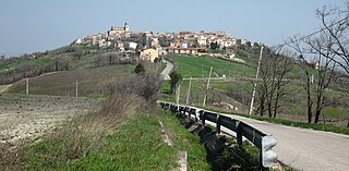
Montelongo is a comune (municipality) in the Province of Campobasso in the Italian region Molise, located about 30 kilometres (19 mi) northeast of Campobasso.

Palata is a comune (municipality) in the Province of Campobasso, located in the Italian region of Molise. It is situated about 35 kilometres (22 mi) northeast of Campobasso.
Portocannone is an Arbëreshë comune in the Province of Campobasso, in the Italian region Molise, located about 50 kilometres (31 mi) northeast of Campobasso.
Ripabottoni is a comune (municipality) in the Province of Campobasso in the Italian region Molise, located about 20 kilometres (12 mi) northeast of Campobasso. As of 31 December 2004, it had a population of 644 and an area of 31.9 square kilometres (12.3 sq mi).
Rotello is a comune (municipality) in the Province of Campobasso in the Italian region Molise, located about 30 kilometres (19 mi) northeast of Campobasso.

San Martino in Pensilis is a comune (municipality) in the Province of Campobasso in the Italian region Molise, located about 45 kilometres (28 mi) northeast of Campobasso.The settlement was formerly inhabited by an Arbëreshë community, who have since assimilated.
Sant'Elia a Pianisi is a comune (municipality) in the Province of Campobasso in the Italian region Molise, located about 20 kilometres (12 mi) northeast of Campobasso. As of 31 December 2004, it had a population of 2,178 and an area of 67.8 square kilometres (26.2 sq mi).
Eccellenza Molise is the regional Eccellenza football division for clubs in the southern Italian region of Molise. It consists of 16 teams competing in one group. The winning team is promoted to Serie D, the top level of Italian amateur football. The club that finishes second may also gain promotion by taking part in a two-round national play-off.

Termoli railway station serves the town and comune of Termoli, in the region of Molise, southern Italy. Opened in 1864, it forms part of the Adriatic Railway (Ancona–Lecce) and is also a terminus for the line to Venafro, linking the comuni of Molise with both the Adriatic and Tyrrhenian seas.

The Termoli–Campobasso railway line is a secondary railway line in Molise, Italy. When it first opened in 1883, the line consisted of 15 stations. Today, only 8 are open to passenger service.

The Ururi-Rotello station is the railway station serving the municipalities of Ururi and Rotello in the province of Campobasso.


