Termoli

Last updated • 6 min readFrom Wikipedia, The Free Encyclopedia
Termoli
Comune di Termoli
Termoli xx.jpg
Panorama of Termoli
Flag of Termoli.svg
Termoli-Stemma.svg
Location of Termoli
Termoli
Italy provincial location map 2016.svg
Red pog.svg
Termoli
Location of Termoli in Italy
Italy Molise location map.svg
Red pog.svg
Termoli
Termoli (Molise)
Coordinates: 42°0′N14°59′E / 42.000°N 14.983°E / 42.000; 14.983
Country Italy
Region Molise
Province Campobasso (CB)
Government
  MayorNico Balice [1]
Area
[2]
  Total
55.64 km2 (21.48 sq mi)
Elevation
15 m (49 ft)
Population
 (31 December 2017) [3]
  Total
32,853
  Density590/km2 (1,500/sq mi)
Demonym Termolesi
Time zone UTC+1 (CET)
  Summer (DST) UTC+2 (CEST)
Postal code
86039
Dialing code 0875
Patron saint Saint Bassus (Basso), Saint Timothy
Saint day3 and 4 August
Website Official website

Termoli (Molisano: Térmëlë) is a comune (municipality) on the south Adriatic coast of Italy, in the province of Campobasso, region of Molise. It has a population of around 32,000, having expanded quickly after World War II, and it is a local resort town known for its beaches and old fortifications. Once it was known only as a fishing port, but in the new millennium it is a favourite resort for Italian families. Termoli contains the only port of the Molise region. There is also a strong competition (especially in the world of sport) with the Campobasso province, in fact some of the "termolesi" (the name of the people that lives in Termoli) like to say that Termoli is province-less ("Termoli senza provincia").

Contents

Geography

Location

Termoli is located in centre-south of Italy, on the Adriatic Coast of Molise Region. The original settlement developed on the promontory where now there's the ancient village, featured by old white and colorful fisherman houses, narrow streets, Trabucchi on the sea, the romanic pugliese cathedral (Duomo), Castello Svevo ( Frederick's Castle of 1200 ) and high walls.

The centre of the city is developed on the nearby ancient village, here you can find many avenues and streets full of life, especially in summer. On the seafront there are several restaurants, hotels and beaches; out of suburbs there are countrysides cultivated with olive trees and wine.

Climate

Termoli has a Mediterranean climate (CSa) tending to semi-arid (BSk) according to Köppen climate classification because precipitation is about 350 mm annual with the autumn as wettest season and a minimum in summer (less 20 mm in July and August).

Winters are mild but the city may experience windy days because of Maestrale (Mistral) which occasionally can bring snow, even if it is a rare phenomenon that occurs in the whole south Italy. Daily mean is about 10 °C (50 °F) with a maximum that can reach from 12 °C (54 °F) to 15 °C (59 °F), above all in days with winds from south and a minimum of 7 °C (46 °F).

Summers are long (they lasts 4 months) and quite hot but thanks to winds they are tolerable with an average high that can generally reach 29/30 °C (85/86 °F); in latest years, as a result of African anticyclone, temperatures were very high reaching 35/40 °C (95/104 °F) also due to southern hot winds from Africa.

In July and August nights are considered "tropicals" because the average low is about 24 °C. Rains are rare but sometimes there can be thunderstorms which doesn't contribute well to the dry situation of summer.

Climate data for Termoli (1991–2020)
MonthJanFebMarAprMayJunJulAugSepOctNovDecYear
Record high °C (°F)24.4
(75.9)
25.0
(77.0)
40.0
(104.0)
29.8
(85.6)
34.8
(94.6)
41.6
(106.9)
41.6
(106.9)
40.8
(105.4)
39.0
(102.2)
33.0
(91.4)
28.4
(83.1)
24.2
(75.6)
41.6
(106.9)
Mean daily maximum °C (°F)11.8
(53.2)
12.3
(54.1)
15.0
(59.0)
17.9
(64.2)
22.2
(72.0)
26.9
(80.4)
29.4
(84.9)
29.7
(85.5)
25.8
(78.4)
21.5
(70.7)
17.1
(62.8)
13.2
(55.8)
20.2
(68.4)
Daily mean °C (°F)9.1
(48.4)
9.4
(48.9)
11.7
(53.1)
14.7
(58.5)
19.0
(66.2)
23.5
(74.3)
26.2
(79.2)
26.4
(79.5)
22.6
(72.7)
18.5
(65.3)
14.3
(57.7)
10.5
(50.9)
17.2
(63.0)
Mean daily minimum °C (°F)6.8
(44.2)
6.9
(44.4)
9.0
(48.2)
11.8
(53.2)
16.1
(61.0)
20.5
(68.9)
23.2
(73.8)
23.5
(74.3)
19.6
(67.3)
15.8
(60.4)
11.8
(53.2)
8.2
(46.8)
14.4
(57.9)
Record low °C (°F)−2.2
(28.0)
−2.8
(27.0)
−0.2
(31.6)
0.0
(32.0)
8.0
(46.4)
11.8
(53.2)
13.6
(56.5)
13.8
(56.8)
11.4
(52.5)
6.0
(42.8)
1.0
(33.8)
−1.0
(30.2)
−2.8
(27.0)
Average precipitation mm (inches)31.29
(1.23)
20.67
(0.81)
23.40
(0.92)
28.63
(1.13)
24.31
(0.96)
16.84
(0.66)
19.50
(0.77)
19.60
(0.77)
48.38
(1.90)
45.11
(1.78)
49.59
(1.95)
34.37
(1.35)
361.69
(14.24)
Average precipitation days (≥ 1.0 mm)6.175.004.674.974.473.132.373.035.476.077.307.4760.12
Average relative humidity (%)76.1274.4672.9974.5475.8373.0572.0972.7373.9675.7176.4375.8374.48
Average dew point °C (°F)5.07
(41.13)
5.04
(41.07)
6.97
(44.55)
10.16
(50.29)
14.63
(58.33)
18.50
(65.30)
20.71
(69.28)
21.18
(70.12)
17.67
(63.81)
14.19
(57.54)
10.19
(50.34)
6.41
(43.54)
12.56
(54.61)
Mean monthly sunshine hours 136.40155.96205.53221.70263.50288.00323.02303.18225.30186.00141.90137.642,588.13
Source: NOAA [4]

History

Human settlements existed in Termoli since pre-historical times, as showed by the presence of ancient necropolis in contrada Porticone and Difesa Grande, as well as from reconnaissance attestations of ville owned by Romans patricians that had their villa near the Molisan coast.

The first documentation of today's city dates to the presence of the ancestor of the current cathedral, documented in the 10th century. Termoli was a Lombard county until the arrival of the Normans, under which flourished and expanded. Later devastations meant a period of decay which lasted until around 1770, when the local nobles were permitted by the Kings of Naples to build new edifices along the coast and in direction of the countryside.

During World War II Termoli became the centre of one of the largest tank battles of the Italian campaign over the period 2 to 6 October, 1943. On the night of 2/3 October, during Operation Devon, British Commandos of the 2nd Special Service Brigade, which comprised No. 3 (Army) Commando, 40 (Royal Marine) Commando and the Special Raiding Squadron landed by sea then cleared the town of most of its German defenders. During the first day these forces set up road blocks around the town and were joined by British infantry advancing across the Biferno river to the south-east. They were unaware that the 16th Panzer Division was on its way to create a new defensive line. On 4 October British reinforcements arrived by sea and land, but tanks were unable to cross the river until engineers completed a bridge for heavy traffic. On 5 October the panzers attacked, pushing much of the British line back in disarray. At the end of the day they were only a short distance from the town. With the arrival of further reinforcements at the port, the engineers were able to complete the bridge allowing tanks to cross. On 6 October the Germans renewed their attack but it soon stalled and the British, with Canadian tanks from the Three Rivers Regiment (12e Régiment blindé du Canada) in support, counter-attacked. They were successful and by 7 October the Germans were pulling back to their next line of defence.

Termoli is rapidly becoming one of the most important centres in the Molise. The latter region suffered from depopulation in the years after World War II and there has been a migration from the internal hill towns to the coastal resort. Its status as the pre-eminent resort site is now being challenged by Campomarino, about five kilometres (3.1 mi) southward.

Main sights

Historical old town

The Castle of Termoli Torre Termoli.jpg
The Castle of Termoli

The old town has been well restored. It is a genuine walled community jutting out into the sea. Many of the houses have been re-built and painted in a range of pastel colours. In a central square there is the cathedral (12th-13th century), dedicated to St. Mary of the Purification: it is a noteworthy example of Apulian Romanesque architecture which houses the relics of the city's two patron saints, Bassus of Lucera (San Basso) and Timothy. The upper part of the façade was destroyed by an earthquake in 1456, and also suffered from the Turkish sack of the city in 1566. The Baroque additions were eliminated in the restoration of 193069, returning the edifice to its original appearance. Part of a pre-existing basilica, built in the 11th century (over the original, smaller cathedral called Ecclesia Sanctae Mater) but soon destroyed, has been found under the edifice.

The castle is the most pre-eminent structure in Termoli. Erected by count Robert I of Loritello during the Norman domination (11th century), it was largely renovated during the rule of Frederick II (1240), after the damage created by an attack of the Venetian fleet. The castle was part of a wider fortification system, including a wall surrounding the entire city, of which only a tower can still be seen.

Seaside resort

Termoli's resorts are renowned for the quality of their beaches and the relative purity of their waters.

Beach in Termoli Termoli Spiaggia di Sant'Antonio.jpg
Beach in Termoli

Very few non-Italians come to stay in this area. Increasingly, the tourists to Molise are from the Naples and Apulia regions, to the south of Molise. Recently palm trees have been planted along the seaside promenade, and in the summer the many restaurants are crowded with visitors from surrounding communities.

Within a radius of about 25 kilometres (16 mi) from Termoli travellers can find the hilltowns of Larino, Casacalenda, Montorio, and Montelongo, which preserve a rural way of life which is disappearing in other, more developed, parts of Italy.

Port and fishing

Trabucco in Termoli Termoli trabucco.jpg
Trabucco in Termoli

Termoli continues to be a port and a fishing town. A distinguishing feature of the old town are the trabucchi , wooden structures for fishing without the use of boats.

Ferries run from Termoli to the Tremiti Islands archipelago in the Adriatic Sea.

Trabucco Termoli pier.jpg
Trabucco

Culture

Termoli hosts several cultural events.

The Kimera Film Festival was established in 2003. Starting from 2008, the public selection of the short movies is held in Termoli, from February to April of every year.

Termoli was also the location of the "Come Inside" [5] video by Jamaican dancehall artist Spice.

Just like the neighboring settlements, Termoli has a Abrëshe population.

Twin towns and sister cities

Termoli is twinned with:

See also

Related Research Articles

<span class="mw-page-title-main">Campobasso</span> City in Molise, Italy

Campobasso is a city and comune in southern Italy, the capital of the region of Molise and of the province of Campobasso. It is located in the high basin of the Biferno river, surrounded by Sannio and Matese mountains.

<span class="mw-page-title-main">Molise</span> Region of Italy

Molise is a region of Southern Italy. Until 1963, it formed part of the region of Abruzzi e Molise together with Abruzzo. The split, which did not become effective until 1970, makes Molise the newest region in Italy. Covering 4,438 square kilometres (1,714 sq mi), it is the second smallest region in the country, after the Aosta Valley, and has a population of 313,348.

<span class="mw-page-title-main">Volturno Line</span> WW2 German defensive line in Italy

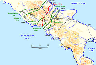
The Volturno Line was a German defensive position in Italy during the Italian Campaign of World War II.

<span class="mw-page-title-main">Pescara</span> Comune in Abruzzo, Italy

Pescara is the capital city of the province of Pescara, in the Abruzzo region of Italy. It is the most populated city in Abruzzo, with 118,657 residents. Located on the Adriatic coast at the mouth of the River Aterno-Pescara, the present-day municipality was formed in 1927 joining the municipalities of the old Pescara fortress, the part of the city to the south of the river, and Castellamare Adriatico, the part of the city to the north of the river. The surrounding area was formed into the province of Pescara.

<span class="mw-page-title-main">Province of Chieti</span> Province of Italy

The province of Chieti is a province in the Abruzzo region of Italy. Its provincial capital is the city Chieti, which has a population of 50,770 inhabitants. The province has a total population of 387,649 inhabitants as of 2017 and spans an area of 2,599.58 square kilometres (1,003.70 sq mi). The province contains 104 comuni. Its provincial president is Mario Pupillo.

<span class="mw-page-title-main">Ortona</span> Comune in Abruzzo, Italy

Ortona is a coastal town and municipality of the Province of Chieti in the Italian region of Abruzzo, with some 23,000 inhabitants.

<span class="mw-page-title-main">Larino</span> Comune in Molise, Italy

Larino is a town and comune of approximately 8,100 inhabitants in Molise, province of Campobasso, southern Italy. It is located in the fertile valley of the Biferno River.

<span class="mw-page-title-main">Province of Campobasso</span> Province of Italy

The province of Campobasso is a province in the Molise region of Italy. Its capital is the city of Campobasso. It covers an area of c. 2,941 square kilometres (1,136 sq mi) and has a total population of 223,871 (2017). There are 84 comuni in the province.

<span class="mw-page-title-main">Shëngjin</span> Municipal unit in Lezhë, Albania

Shëngjin is a coastal town and a former municipality in Lezhë County, northwestern Albania. At the 2015 local government reform it became a subdivision of the municipality of Lezhë. The population at the 2023 census was 6,963. Shëngjin is a growing tourist destination, well known for its beaches and resort accommodations. Shëngjin is one of many cities within the District of Lezhë and is home to one of Albania's entry ports, Port of Shëngjin.

<span class="mw-page-title-main">Campobasso FC</span> Italian football club

Campobasso Football Club, commonly referred to as Campobasso, is an Italian football club located in Campobasso, Molise, currently playing in Serie C, the third tier of Italian football.

<span class="mw-page-title-main">Pineto</span> Comune in Abruzzo, Italy

Pineto is a town and comune in the province of Teramo, Abruzzo, in central Italy. It is a 20th-century seaside resort on the Adriatic coast, with sandy beaches shaded by pine trees that give their name to the town.

<span class="mw-page-title-main">Casacalenda</span> Comune in Molise, Italy

Casacalenda is a comune (municipality) in the Province of Campobasso in the Italian region Molise, located about 25 kilometres (16 mi) northeast of Campobasso.

<span class="mw-page-title-main">Colletorto</span> Comune in Molise, Italy

Colletorto is a comune (municipality) of approximately 1,786 inhabitants in the province of Campobasso, in the Italian region of Molise, located about 45 kilometres (28 mi) from the capital of the region Campobasso and 40 kilometres (25 mi) from Termoli (CB), sea town with port, railway and highway A14.

<span class="mw-page-title-main">Guardialfiera</span> Comune in Molise, Italy

Guardialfiera is a comune (municipality) in the Province of Campobasso in the Italian region Molise, located about 30 kilometres (19 mi) northeast of Campobasso. It sits on a hilltop overlooking Lake Guardialfiera, which was created as a result of the damming of the Biferno river.

<i>Trabucco</i>

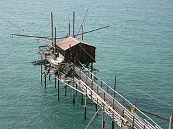
The trabucco, known in some southern dialects as trabocco or travocc, is an ancient fishing machine typical of the Adriatic shores of Abruzzo — famously dubbed the Costa dei Trabocchi and the Gargano coast, where they are preserved as historical monuments within the Gargano National Park. These distinctive structures are prevalent along the southern Adriatic coastline, particularly in the Italian provinces of Chieti, Campobasso, and Foggia. Trabucchi can also be found on select parts of the southern Tyrrhenian Sea coast.

Operation Devon was the code name of an amphibious landing by British Commandos in 1943 at Termoli, on the Adriatic coast of Italy, during the Italian Campaign of World War II.

<span class="mw-page-title-main">Termoli railway station</span>

Termoli railway station serves the town and comune of Termoli, in the region of Molise, southern Italy. Opened in 1864, it forms part of the Adriatic Railway (Ancona–Lecce) and is also a terminus for the line to Venafro, linking the comuni of Molise with both the Adriatic and Tyrrhenian seas.

Molisan is a group of dialects of the Neapolitan language spoken in Molise, a region of Southern Italy.

<span class="mw-page-title-main">Termoli–Campobasso railway</span> Italian railway line

The Termoli–Campobasso railway line is a secondary railway line in Molise, Italy. When it first opened in 1883, the line consisted of 15 stations. Today, only 8 are open to passenger service.

<span class="mw-page-title-main">Benevento–Campobasso railway</span> Italian regional railway

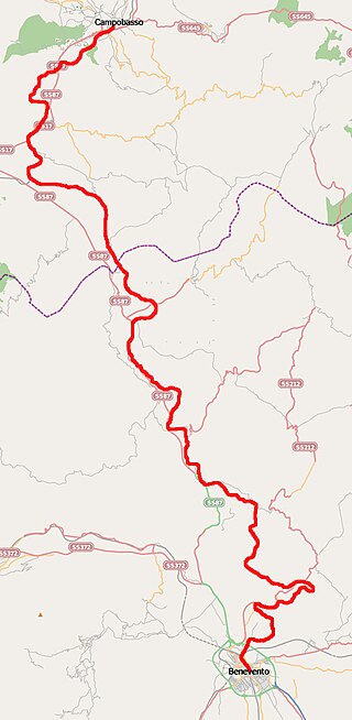
The Benevento–Campobasso railway is a secondary Italian railway line in Campania and Molise connecting Benevento with Campobasso of Samnium. Planned as an alternative to the Naples–Foggia railway to connect the Tyrrhenian Sea to the Adriatic Sea, but later deemed very slow and therefore uncompetitive, it has never been affected by large volumes of traffic.

References

  1. "Amministrazione".
  2. "Superficie di Comuni Province e Regioni italiane al 9 ottobre 2011". Italian National Institute of Statistics. Retrieved 16 March 2019.
  3. "Popolazione Residente al 1° Gennaio 2018". Italian National Institute of Statistics. Retrieved 16 March 2019.
  4. "World Meteorological Organization Climate Normals for 1991-2020 — Termoli". National Oceanic and Atmospheric Administration. Retrieved February 3, 2024.
  5. "Come Inside"