Sanctuary, Texas

Last updated

Sanctuary, Texas
TXMap-doton-Sanctuary.PNG
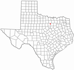
Location of Sanctuary, Texas
Parker County Sanctuary.svg
Coordinates: 32°54′32″N97°35′3″W / 32.90889°N 97.58417°W / 32.90889; -97.58417
Country United States
State Texas
County Parker
Area
[1]
  Total0.86 sq mi (2.22 km2)
  Land0.86 sq mi (2.22 km2)
  Water0.00 sq mi (0.00 km2)
Elevation
768 ft (234 m)
Population
 (2010)
  Total329
  Estimate 
(2019) [2]
321
  Density374.56/sq mi (144.70/km2)
Time zone UTC-6 (Central (CST))
  Summer (DST) UTC-5 (CDT)
FIPS code 48-65066 [3]
GNIS feature ID1388545 [4]

Sanctuary is a town in Parker County, Texas, United States. The population was 329 at the 2010 census, and the community was incorporated in the early 1980s. [5]

Contents

Geography

Sanctuary is located at 32°54′32″N97°35′3″W / 32.90889°N 97.58417°W / 32.90889; -97.58417 (32.908822, –97.584209). [6]

According to the United States Census Bureau, the town has a total area of 0.3 square miles (0.78 km2), all land.

Demographics

Historical population
CensusPop.Note
1980 215
1990 2348.8%
2000 2569.4%
2010 32928.5%
2019 (est.)321 [2] −2.4%
U.S. Decennial Census [7]

As of the census [3] of 2000, there were 256 people, 99 households, and 80 families residing in the town. The population density was 970.9 inhabitants per square mile (374.9/km2). There were 111 housing units at an average density of 421.0 per square mile (162.5/km2). The racial makeup of the town was 94.14% White, 0.39% Native American, 3.91% from other races, and 1.56% from two or more races. Hispanic or Latino of any race were 4.69% of the population.

There were 99 households, out of which 33.3% had children under the age of 18 living with them, 70.7% were married couples living together, 7.1% had a female householder with no husband present, and 18.2% were non-families. 17.2% of all households were made up of individuals, and 6.1% had someone living alone who was 65 years of age or older. The average household size was 2.59 and the average family size was 2.88.

In the town, the population was spread out, with 23.4% under the age of 18, 8.6% from 18 to 24, 24.6% from 25 to 44, 30.5% from 45 to 64, and 12.9% who were 65 years of age or older. The median age was 41 years. For every 100 females, there were 106.5 males. For every 100 females age 18 and over, there were 98.0 males.

The median income for a household in the town was $51,667, and the median income for a family was $54,063. Males had a median income of $36,406 versus $26,250 for females. The per capita income for the town was $17,951. About 5.4% of families and 7.8% of the population were below the poverty line, including 14.1% of those under the age of eighteen and none of those 65 or over.

Education

The Town of Sanctuary is served by the Azle Independent School District.

Related Research Articles

<span class="mw-page-title-main">Arizona Village, Arizona</span> Census-designated place in Arizona, United States

Arizona Village is a census-designated place (CDP) on the Fort Mojave Indian Reservation in Mohave County, Arizona, United States. The population was 1,057 at the 2020 census, up from 946 in 2010 and 351 in 2000.

<span class="mw-page-title-main">Kearny, Arizona</span> Town in Pinal County, Arizona

Kearny is a town in Pinal County, Arizona, United States. The town was named after General Stephen Watts Kearny, who passed through the area on November 7, 1846, while leading 100 dragoons to California. According to the 2010 census, the population of the town is 1,950. The economic base of Kearny and nearby towns is the Ray mine and Hayden Smelter, both owned and operated by ASARCO.

<span class="mw-page-title-main">Sherman, Maine</span> Town in the state of Maine, United States

Sherman is a town in Aroostook County, Maine, United States. The population was 815 at the 2020 census.

<span class="mw-page-title-main">Westfield, Maine</span> Town in the state of Maine, United States

Westfield is a town in Aroostook County, Maine, United States. The population was 455 at the 2020 census.

<span class="mw-page-title-main">Chesterville, Maine</span> Town in Maine, United States

Chesterville is a town in Franklin County, Maine, United States. The population was 1,328 at the 2020 census.

<span class="mw-page-title-main">West Gardiner, Maine</span> Town in the state of Maine, United States

West Gardiner is a town in Kennebec County, Maine, United States. The population was 3,671 at the 2020 census. West Gardiner is included in the Augusta, Maine micropolitan New England City and Town Area.

<span class="mw-page-title-main">Shiawassee Township, Michigan</span> Civil township in Michigan, United States

Shiawassee Township is a civil township of Shiawassee County in the U.S. state of Michigan. The population was 2,840 at the 2010 census.

<span class="mw-page-title-main">Kennedy, Minnesota</span> City in Minnesota, United States

Kennedy is a city in Kittson County, Minnesota, United States. The population was 176 at the 2020 census.

<span class="mw-page-title-main">Sunburst, Montana</span> Town in Montana, United States

Sunburst is a town in Toole County, Montana, United States. The population was 333 in the 2020 census.

<span class="mw-page-title-main">Philo, Ohio</span> Village in Ohio, United States

Philo is a village in Muskingum County, Ohio, United States, along the Muskingum River. The population was 720 at the 2020 census. It is part of the Zanesville micropolitan area. Philo is the closest municipality to Blue Rock State Park.

<span class="mw-page-title-main">Etowah, Oklahoma</span> Town in Oklahoma, United States

Etowah is a town in Cleveland County, Oklahoma, United States. The population was 159 at the 2020 census, a 72.8% increase from 2010.

<span class="mw-page-title-main">Odem, Texas</span> City in Texas, United States

Odem is a city in San Patricio County, Texas, United States. Its population was 2,389 at the 2010 census.

<span class="mw-page-title-main">Cana, Virginia</span> CDP in Virginia, United States

Cana is a census-designated place (CDP) in Carroll County, Virginia, United States. The population was 1,254 at the 2010 census, up from 1,228 in 2000. It is the only CDP designated area in the county that is outside of the Appalachian Mountains in the Virginia Piedmont.

<span class="mw-page-title-main">Branchville, Virginia</span> Town in Virginia, United States

Branchville is a town in Southampton County, Virginia, United States. The population was 123 at the 2000 census.

<span class="mw-page-title-main">Rhodell, West Virginia</span> Unincorporated community in West Virginia, United States

Rhodell is an unincorporated community in Raleigh County, West Virginia, United States. The population was 173 at the 2010 census.

<span class="mw-page-title-main">Hambleton, West Virginia</span> Town in West Virginia, United States

Hambleton is a town in Tucker County, West Virginia, United States. The population was 216 at the 2020 census. Hambleton was established in 1889, but not incorporated until 1905. It was named by then United States Senator Stephen B. Elkins in honor of a stockholder by this name in the West Virginia Central Railroad Company. The town was previously known as Hulings.

<span class="mw-page-title-main">North Hills, West Virginia</span> Town in West Virginia, United States

North Hills is a town in Wood County, West Virginia, United States. It is a suburb of Parkersburg. The population was 837 at the 2020 census. North Hills was incorporated on February 15, 1979.

Boulder Flats is a census-designated place (CDP) in Fremont County, Wyoming, United States. The population was 408 at the 2010 census.

McCormack is an unorganized territory in Saint Louis County, Minnesota, United States, located near Hibbing and Balkan Township. The population was 237 at the 2000 census.

<span class="mw-page-title-main">Scott, Ohio</span> Village in Ohio, United States

Scott is a village in Paulding and Van Wert counties in the U.S. state of Ohio. The population was 242 at the 2020 census. The Van Wert County portion of Scott is part of the Van Wert Micropolitan Statistical Area.

References

  1. "2019 U.S. Gazetteer Files". United States Census Bureau. Retrieved August 7, 2020.
  2. 1 2 "Population and Housing Unit Estimates". United States Census Bureau. May 24, 2020. Retrieved May 27, 2020.
  3. 1 2 "U.S. Census website". United States Census Bureau . Retrieved January 31, 2008.
  4. "US Board on Geographic Names". United States Geological Survey. October 25, 2007. Retrieved January 31, 2008.
  5. "TSHA | Sanctuary, TX".
  6. "US Gazetteer files: 2010, 2000, and 1990". United States Census Bureau. February 12, 2011. Retrieved April 23, 2011.
  7. "Census of Population and Housing". Census.gov. Retrieved June 4, 2015.