Sandbeach, Pennsylvania

Last updated

Sandbeach, Pennsylvania
Unincorporated community
Southwestern Approach Sandbeach PA.JPG
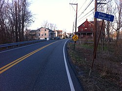
Southwestern approach to Sandbeach
USA Pennsylvania location map.svg
Red pog.svg
Sandbeach
Coordinates: 40°18′32″N76°40′5″W / 40.30889°N 76.66806°W / 40.30889; -76.66806
Country United States
State Pennsylvania
County Dauphin
Township South Hanover
Elevation
361 ft (110 m)
Time zone UTC-5 (Eastern (EST))
  Summer (DST) UTC-4 (EDT)
Area code 717

Sand Beach (variant name Sandbeach [1] ) is an unincorporated community in South Hanover Township, Dauphin County, Pennsylvania, United States, situated in the Harrisburg-Carlisle Metropolitan Statistical Area, in the vicinity of the census-designated place of Hershey. It lies at the point where the smaller Manada Creek joins the Swatara Creek.

Contents

It was founded as Manadaville. The village would later take its name after a post office in the area. [2]

Sand Beach Covered Bridge

The Sand Beach Covered Bridge or Church Ford Covered Bridge was a 220-foot (67 m) Burr arch truss covered bridge built in 1853 and again in 1906 that crossed Swatara Creek between Derry Township and South Hanover Township. The bridge, restored by Hershey Enterprises in 1964, burned the night of September 3, 1966. [3]

Related Research Articles

<span class="mw-page-title-main">Dauphin County, Pennsylvania</span> County in Pennsylvania, United States

Dauphin County is a county in the Commonwealth of Pennsylvania. As of the 2020 census, the population was 286,401. The county seat is Harrisburg, Pennsylvania's state capital and ninth-most populous city. The county was created on March 4, 1785, from part of Lancaster County and was named after Louis Joseph, Dauphin of France, the first son of King Louis XVI.

<span class="mw-page-title-main">Hummelstown, Pennsylvania</span> Borough in Pennsylvania, United States

Hummelstown is a borough in Dauphin County, Pennsylvania, United States. The population was 4,535 as of the 2020 census. It is part of the Harrisburg–Carlisle Metropolitan Statistical Area.

<span class="mw-page-title-main">Lower Paxton Township, Pennsylvania</span> Township in Pennsylvania, United States

Lower Paxton is a township in Dauphin County, Pennsylvania, United States. The population was 53,501 at the 2020 census. It is the most populous municipality in Dauphin County and the 17th-most populated municipality in the state.

<span class="mw-page-title-main">Lower Swatara Township, Pennsylvania</span> Township in Pennsylvania, United States

Lower Swatara Township is a township in Dauphin County, Pennsylvania, United States. The population was 9,557 at the 2020 census. Harrisburg International Airport and Penn State Harrisburg are located within the township. It shares a ZIP Code with the nearby borough of Middletown, and all locations in the township have Middletown addresses.

<span class="mw-page-title-main">South Hanover Township, Pennsylvania</span> Township in Pennsylvania, United States

South Hanover Township is a township in Dauphin County, Pennsylvania, United States. The population was 7,200 at the 2020 census, an increase over the figure of 6,248 tabulated in 2010.

<span class="mw-page-title-main">Swatara Creek</span> River

The South Mountain Railroad was an American railroad which operated in Pennsylvania.

WITF-TV is a non-commercial television station in Harrisburg, Pennsylvania, United States, a member station of PBS serving the Susquehanna Valley region (Harrisburg–Lancaster–Lebanon–York). It is owned by WITF, Inc., alongside the area's NPR member, WITF-FM (89.5). Both stations share studios at the WITF Public Media Center in Swatara Township, while WITF-TV's transmitter is located in Middle Paxton Township, next to the transmitter of CBS affiliate WHP-TV. WITF's programming is relayed on low-power digital translator station W20EU-D in Chambersburg.

<span class="mw-page-title-main">Pennsylvania Route 39</span> State highway in Dauphin County, Pennsylvania, United States

Pennsylvania Route 39 (PA 39) is a 17.83-mile-long (28.69 km) state highway located in Dauphin County, Pennsylvania, United States. PA 39 runs from North Front Street near Harrisburg east to U.S. Route 322 (US 322) and US 422 near Hummelstown and Hershey. The route passes through the northern and eastern suburbs of Harrisburg and passes by Hersheypark, Giant Center, as well as the primary production factory for The Hershey Company. Between Harrisburg and Manada Hill, it is known as Linglestown Road, from Manada Hill to Hershey as Hershey Road and from Hershey to near Hummelstown and Hershey as Hersheypark Drive. Prior to the establishment of PA 39 in 1937, PA 39, had previously been designated as a route in northeastern Pennsylvania during the 1920s. That designation was deleted when it was renumbered US 11. As a result, PA 39 is one of a few routes which has a set of child routes which are no where near the primary route.

Chambers Hill is a community in Swatara Township in Dauphin County, Pennsylvania. It is located in the area between 40 degrees 15'41 North and 76 degrees 48'42 West, between Harrisburg and Hershey. With ranges in elevation from 415–660 feet a view of the Harrisburg skyline to the west, or Three Mile Island to the south, can often be seen. The aroma of cocoa is often in the air when the wind comes in from the Hershey's Chocolate World to the east. The area is bounded by U.S. Route 322 to the north and Pennsylvania Route 283 to the West. Routes 83, 81, 11, 15 and the Pennsylvania Turnpike are within a five-minute drive. Swatara Creek bounds the hill to the east, and Lower Swatara Township and Strites Orchard provide the boundary to the south. The area is served by one elementary school, policed by the Swatara Township Police department, and protected from fire by the Chambers Hill Fire Company.

<span class="mw-page-title-main">Pennsylvania Route 743</span> State highway in Pennsylvania, US

Pennsylvania Route 743 is a north–south state route located in central Pennsylvania. The southern terminus is at PA 441 in Marietta. The northern terminus is at U.S. Route 22 near the East Hanover Township hamlet of Grantville though some signage has it continue north past Interstate 81 (I-81) to PA 443. The route runs north through Lancaster County, passing through Maytown before reaching Elizabethtown. Here, the route has concurrencies with PA 230 and PA 241 and comes to an interchange with the PA 283 freeway. PA 743 continues into Dauphin County and crosses PA 341 before reaching Hershey. In Hershey, the route follows Cocoa Avenue between US 322 and US 422, the latter which is known as Chocolate Avenue. PA 743 follows Park Avenue north past Hersheypark and Hersheypark Drive east before heading north on Laudermilch Road from Hershey to Grantville.

Pennsylvania State Senate District 15 includes part of Dauphin County. It is currently represented by Republican John DiSanto.

<span class="mw-page-title-main">Manada Creek</span> Tributary of Swatara Creek

Manada Creek is a 17.0-mile-long (27.4 km) tributary of Swatara Creek in Dauphin County, Pennsylvania in the United States. The watershed drains approximately 32 sq mi (83 km). The name is derived the Lenape word "menatey", meaning "island".

The 106th Pennsylvania House of Representatives District is located in South Central Pennsylvania and has been represented since 2017 by Republican Tom Mehaffie.

Manada Gap is an unincorporated community in East Hanover Township, Dauphin County, Pennsylvania, United States, located in the Harrisburg-Carlisle area, near Fort Indiantown Gap.

Bow Creek is a 7.8-mile-long (12.6 km) tributary of Swatara Creek in Dauphin County, Pennsylvania, in the United States.

<span class="mw-page-title-main">Union Deposit, Pennsylvania</span> Census-designated place in Pennsylvania, United States

Union Deposit is an unincorporated community and census-designated place in South Hanover Township, Dauphin County, Pennsylvania, United States. It is part of the Harrisburg–Carlisle Metropolitan Statistical Area. As of the 2010 census the population of Union Deposit was 407 residents.

<span class="mw-page-title-main">Hoernerstown, Pennsylvania</span> Unincorporated community in Pennsylvania, United States

Hoernerstown is an unincorporated community in South Hanover Township, Dauphin County, Pennsylvania, United States and is a part of the Harrisburg–Carlisle Metropolitan Statistical Area.

Swatara is an unincorporated community in Derry Township, Dauphin County, Pennsylvania, United States, located near Hershey in the Harrisburg–Carlisle metropolitan statistical area.

<span class="mw-page-title-main">Timeline of Harrisburg, Pennsylvania history</span>

This is a timeline of the major events in the history of Harrisburg, Pennsylvania and vicinity.

References

  1. U.S. Geological Survey Geographic Names Information System: Sandbeach, Pennsylvania
  2. Notes and Queries, Historical, Biographical and Genealogical, Relating Chiefly to Interior Pennsylvania. Harrisburg Publishing Company. 1895. pp. 14–.
  3. Pennsylvania's Covered Bridges. Fred J. Moll. 2012. p. 43. ISBN   9780738592497.