The Entrada Sandstone is a formation in the San Rafael Group found in the U.S. states of Wyoming, Colorado, northwest New Mexico, northeast Arizona, and southeast Utah. Part of the Colorado Plateau, this formation was deposited during the Jurassic Period sometime between 180 and 140 million years ago in various environments, including tidal mudflats, beaches, and sand dunes. The Middle Jurassic San Rafael Group was dominantly deposited as ergs in a desert environment around the shallow Sundance Sea.

Ute Mountain, also known as Ute Peak or Sleeping Ute Mountain, is a peak within the Ute Mountains, a small mountain range in the southwestern corner of Colorado. It is on the northern edge of the Ute Mountain Ute Tribe Reservation. The Reservation forms the southwestern corner of the state and of Montezuma County.

The Fruitland Formation is a geologic formation found in the San Juan Basin in the states of New Mexico and Colorado, in the United States of America. It contains fossils dating it to the Campanian age of the late Cretaceous.

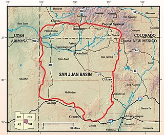
The San Juan Basin is a geologic structural basin located near the Four Corners region of the Southwestern United States. The basin covers 7,500 square miles and resides in northwestern New Mexico, southwestern Colorado, and parts of Utah and Arizona. Specifically, the basin occupies space in the San Juan, Rio Arriba, Sandoval, and McKinley counties in New Mexico, and La Plata and Archuleta counties in Colorado. The basin extends roughly 100 miles (160 km) N-S and 90 miles (140 km) E-W.

The Dakota is a sedimentary geologic unit name of formation and group rank in Midwestern North America. The Dakota units are generally composed of sandstones, mudstones, clays, and shales deposited in the Mid-Cretaceous opening of the Western Interior Seaway. The usage of the name Dakota for this particular Albian-Cenomanian strata is exceptionally widespread; from British Columbia and Alberta to Montana and Wisconsin to Colorado and Kansas to Utah and Arizona. It is famous for producing massive colorful rock formations in the Rocky Mountains and the Great Plains of the United States, and for preserving both dinosaur footprints and early deciduous tree leaves.

The Bisti/De-Na-Zin Wilderness is a 45,000-acre (18,000 ha) wilderness area located in San Juan County in the U.S. state of New Mexico. Established in 1984, the Wilderness is a desolate area of steeply eroded badlands managed by the Bureau of Land Management, except three parcels of private Navajo land within its boundaries. The John D. Dingell, Jr. Conservation, Management, and Recreation Act, signed March 12, 2019, expanded the Bisti/De-Na-Zin Wilderness by approximately 2,250 acres.
The Moreno Hill Formation is a geological formation in western New Mexico whose strata were deposited in the Late Cretaceous. Dinosaur remains are among the fossils that have been recovered from the formation.

The Aguja Formation is a geological formation in North America, exposed in Texas, United States and Chihuahua and Coahuila in Mexico, whose strata date back to the Late Cretaceous. Dinosaur remains are among the fossils that have been recovered from the formation. Fossil palms have also been unearthed here.
The Crevasse Canyon Formation is a coal-bearing Cretaceous geologic formation in New Mexico and Arizona.

The Point Lookout Sandstone is a Cretaceous bedrock formation occurring in New Mexico and Colorado.

The Menefee Formation is a lower Campanian geologic formation found in Colorado and New Mexico, United States.

The Mancos Shale or Mancos Group is a Late Cretaceous geologic formation of the Western United States.
Astragalus humillimus is a rare species of milkvetch known by the common name Mancos milkvetch. It is native to a small section of the Four Corners region of the United States, where it can be found in Montezuma County, Colorado, and San Juan County, New Mexico. There are about nine small, localized populations on sandstone rimrock ledges on the mesas. The plant occurs in a region that is being developed for oil and gas exploration, and altered by associated activities such as road construction and pipeline installation. It is a federally listed endangered species.

San Mateo Mesa is located in McKinley County, New Mexico, approximately 5 miles northwest of San Mateo. There are two large mesas, called San Mateo Mesa South and San Mateo Mesa North.
Meristodonoides is an extinct genus of cartilaginous fish. The type species is M. rajkovichi, which was originally a species in the genus Hybodus. The species, along with other Hybodus species such as H. butleri and H. montanensis, was reassigned to Meristodonoides by Charlie J. Underwood and Stephen L. Cumbaa in 2010.

The Burro Canyon Formation is an Early Cretaceous Period sedimentary geologic formation, found in western Colorado, the Chama Basin and eastern San Juan Basin of northern New Mexico, and in eastern Utah, US.

Point Lookout is an 8,427-foot elevation sandstone summit located in Mesa Verde National Park, in Montezuma County of southwest Colorado. This prominent landmark is situated 2 miles (3.2 km) south of the park entrance, and 9.3 miles (15.0 km) east-southeast of the town of Cortez, and towers 1,600 feet above the surrounding terrain of Mancos Valley. Soldiers from Fort Lewis army post used its lofty position to send heliographic signals to troops campaigning in the west. A trail climbs 2.2 miles round-trip to the top and offers views of Montezuma and Mancos valleys, as well as the La Plata Mountains. This geographical feature's name was officially adopted in 1934 by the U.S. Board on Geographic Names.

Chimney Rock is an 6,110-foot (1,860 meter) elevation pillar located within the Ute Mountain Tribal Park, in Montezuma County of southwest Colorado. This landmark is situated one mile southeast of the junction of U.S. Route 491 and US 160, and towers 900 feet above the floor of the Mancos River Valley. This geographical feature is also known as Jackson Butte, named for William Henry Jackson (1843–1942), photographer and explorer famous for his images of the American West who visited this area during the Hayden Survey. He was the first to photograph the cliff dwellings in this Mesa Verde region of the Four Corners area.

Menefeeceratops is a genus of ceratopsid dinosaur from the Menefee Formation in New Mexico, United States. It is potentially the oldest known member of the ceratopsids, as well as the centrosaurine subfamily, related to animals including Yehuecauhceratops and Crittendenceratops. The type and only species is Menefeeceratops sealeyi, known from a partial, non-articulated skeleton.


