James Island is a town in Charleston County, South Carolina, United States. It is located in the central and southern parts of James Island. James Island is included within the Charleston-North Charleston-Summerville metropolitan area and the Charleston-North Charleston Urbanized Area.

This is a list of the properties and historic districts in each of the 46 counties of South Carolina that are designated National Register of Historic Places.

In the law regulating historic districts in the United States, a contributing property or contributing resource is any building, object, or structure which adds to the historical integrity or architectural qualities that make the historic district significant. Government agencies, at the state, national, and local level in the United States, have differing definitions of what constitutes a contributing property but there are common characteristics. Local laws often regulate the changes that can be made to contributing structures within designated historic districts. The first local ordinances dealing with the alteration of buildings within historic districts was passed in Charleston, South Carolina in 1931.

Edenton Historic District is a national historic district located at Edenton, Chowan County, North Carolina. The district encompasses 342 contributing buildings, 4 contributing sites, and 3 contributing structures. It includes several buildings that are individually listed on the National Register. The Lane House, possibly the oldest surviving house in North Carolina, is owned by Steve and Linda Lane and is located within the district. Also located in the district are the Dixon-Powell House, William Leary House, and Louis Ziegler House designed by architect George Franklin Barber.

This is a list of the National Register of Historic Places listings in Charleston County, South Carolina.

This is a list of the National Register of Historic Places listings in Charleston, South Carolina.

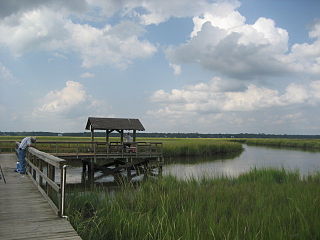
Marshlands Plantation House, in Charleston, South Carolina, is an historic plantation house that was built in 1810 and listed in the National Register of Historic Places on March 30, 1973. It is a 2 1⁄2-story Federal-style plantation home. The house was relocated in the 1960s from its original location on the site of the United States Navy Shipyard. The Navy had announced it would have to demolish the empty house if it could not be relocated with the $15,000 the Navy had set aside for the purpose. The City of Charleston took temporary possession of the house, transferring it to the College of Charleston which relocated it for preservation to James Island.

Charleston Navy Yard Officers' Quarters Historic District is a national historic district located at the former Charleston Naval Shipyard in North Charleston, South Carolina. It encompasses 24 contributing buildings, 2 contributing sites, 1 contributing structure, and 1 contributing object. The site represents development of the upper echelon of senior military housing, support structures, sports facilities and recreational landscape features from 1901 through 1945. The buildings reflect late Victorian and early-20th century eclectic designs including the Italianate, Neo-Classical, Italian Renaissance Revival, Colonial Revival, and the Works Progress Administration (WPA) designed Panama House style.
Buzzard's Island Site is a historic mound located near Mount Pleasant, Charleston County, South Carolina. It is one of 20 or more prehistoric shell rings located from the central coast of South Carolina to the central coast of Georgia. On average, it measures 178 feet in diameter and stands 3 feet high. The midden is largely composed of oyster shell.
Lighthouse Point Shell Ring (38CH12), also known as Parrot's Point Shell Ring, is a historic mound located on James Island, Charleston County, South Carolina. It is one of 20 or more prehistoric shell rings located from the central coast of South Carolina to the central coast of Georgia. The midden contains a diverse array of biota.

Moving Star Hall is a historic community building located at Johns Island, Charleston County, South Carolina. It was built about 1917, and is a crudely built, one-story, rectangular, frame, weatherboarded building. It has a low concrete block pillar foundation and a metal-covered gable roof. Also on the property is a contributing outhouse. The building was used by the local African-American population as a "praise house" and meeting place of the Moving Star Young Association, a religious, social, fraternal, and charitable community institution.
Towles Farmstead, also known as Goshen Plantation and Plainsfield, is a historic farmstead and national historic district located near Meggett, Charleston County, South Carolina. The district encompasses 11 contributing buildings, 2 contributing sites, and 1 contributing structure. They include two early-20th century residences: a one-story, frame house constructed about 1903, with characteristic Neo-Classical and Bungalow features; and a two-story, rectangular frame house constructed in 1930, with characteristic Colonial Revival and Italian Renaissance features. Associated with the houses are a variety of contributing utility outbuildings.

Rockville Historic District is a national historic district located at Rockville, Charleston County, South Carolina. The district encompasses 19 contributing buildings in the town of Rockville. The dwellings reflect Rockville's historic role as a summer resort town. The houses are characterized by spacious porches, raised foundations, and large central hallways designed for summer comfort and relaxation. Located in the district are the Grace Episcopal Church and Wadmalaw Presbyterian Church.

Mount Pleasant Historic District is a national historic district located at Mount Pleasant, Charleston County, South Carolina. The district encompasses nine contributing buildings in the town of Mount Pleasant. The dwellings reflect Mount Pleasant's historic role as a summer resort town. The building reflect architectural styles of the 18th, 19th and early 20th centuries, including vernacular Georgian, Greek Revival and Gothic Revival. Notable buildings include the Mount Pleasant Presbyterian Church, St. Andrews Episcopal Church, Mount Pleasant Seventh-Day Adventist Church, Hibben-McIver House, 200 Bank Street, and the Captain Peter Lewis House. Located in the district is the separately listed Old Courthouse.
McClellanville Historic District is a national historic district located at McClellanville, Charleston County, South Carolina. The district encompasses 105 contributing buildings in the town of McClellanville. They include residential, commercial, religious and educational building dating between about 1860 to 1935. Architectural styles include: Carpenter Gothic, Queen Anne, and Italianate. Notable buildings include the King Brothers Store, McClellanville Public School, New Wappetaw Presbyterian Church, Bank of McClellanville, McClellanville Methodist Episcopal Church, and a number of dwellings originally built as summer homes by St. James Santee and Georgetown planters.
Atlanticville Historic District is a national historic district located at Sullivan's Island, Charleston County, South Carolina. The district encompasses 45 contributing buildings, 1 contributing site, and 1 contributing structure in Atlanticville. They predominantly include frame residences built between about 1880 to 1950 which are known as “island houses.” Also located in the district are the Chapel of the Holy Cross and the Sullivan's Island Graded School.

Moultrieville Historic District is a national historic district located at Sullivan's Island, Charleston County, South Carolina. The district encompasses 18 contributing buildings and 1 contributing site in Moultrieville. They predominantly include frame residences built between about 1830 to 1930 which are known as "Island Houses." Also located in the district are the Stella Maris Catholic Church (1869-1873) and Fort Moultrie Torpedo Shed/Mines Storehouse.

Sullivan's Island Historic District is a national historic district located at Sullivan's Island, Charleston County, South Carolina. The district encompasses 36 contributing buildings on Sullivan's Island. They predominantly include the core residential and administrative areas of Fort Moultrie built between about 1870 to 1950. Also included are representative "Island Houses" and the Post Chapel. Notable buildings include the Base Commander's Quarters, nine Senior Officers' Quarters, ten Junior Officers' Quarters, the Bachelor Officers' Quarters, the Administration Building, the Post Exchange and Gymnasium, and the Electrical Shop.

U.S. Coast Guard Historic District is a national historic district located at Sullivan's Island, Charleston County, South Carolina. The district encompasses three contributing buildings and one contributing structure on Sullivan's Island. The property was established as a life saving station in 1891. The district contains the station house/administration building, boathouse, garage, and signal tower, which are laid out in an "L"-shaped court loosely organized around the bunker/sighting station. Also on the property is the non-contributing Charleston Light.


