Sedalia, North Carolina

Last updated

Sedalia, North Carolina
Guilford County North Carolina incorporated and unincorporated areas Sedalia highlighted.svg
Location in Guilford County and the state of North Carolina
Coordinates: 36°04′42″N79°37′43″W / 36.07833°N 79.62861°W / 36.07833; -79.62861
Country United States
State North Carolina
County Guilford
Area
[1]
  Total2.01 sq mi (5.20 km2)
  Land2.00 sq mi (5.18 km2)
  Water0.01 sq mi (0.02 km2)
Elevation
[2]
663 ft (202 m)
Population
 (2020)
  Total676
  Density338.17/sq mi (130.55/km2)
Time zone UTC-5 (Eastern (EST))
  Summer (DST) UTC-4 (EDT)
ZIP code
27342
Area code 336
FIPS code 37-60180 [3]
GNIS feature ID2407307 [2]
Website sedalianc.org

Sedalia is a town in Guilford County, North Carolina, United States. The population was 623 at the 2010 census. [4]

Contents

History

The Dr. Joseph A. McLean House and Palmer Memorial Institute Historic District are listed on the National Register of Historic Places. [5]

Geography

Sedalia is located in eastern Guilford County. U.S. Route 70 (Burlington Road) passes through the center of the town, leading east 11 miles (18 km) to Burlington and west 11 miles (18 km) to Greensboro. Interstate 40 passes just south of Sedalia, with access from Exit 135 (Rock Creek Dairy Road).

According to the United States Census Bureau, the town has a total area of 2.1 square miles (5.4 km2), of which 0.01 square miles (0.02 km2), or 0.30%, is water. [4]

Demographics

Historical population
CensusPop.Note
2000 618
2010 6230.8%
2020 6768.5%
U.S. Decennial Census [6]

As of the census [3] of 2000, there were 618 people, 226 households, and 181 families residing in the town. The population density was 266.8 inhabitants per square mile (103.0/km2). There were 240 housing units at an average density of 103.6 per square mile (40.0/km2). The racial makeup of the town was 13.92% White, 83.82% African American, 0.16% Asian, 0.32% from other races, and 1.78% from two or more races. Hispanic or Latino of any race were 0.32% of the population.

There were 226 households, out of which 27.0% had children under the age of 18 living with them, 51.3% were married couples living together, 22.6% had a female householder with no husband present, and 19.9% were non-families. 18.6% of all households were made up of individuals, and 5.8% had someone living alone who was 65 years of age or older. The average household size was 2.71 and the average family size was 3.03.

In the town, the population was spread out, with 20.6% under the age of 18, 9.7% from 18 to 24, 24.1% from 25 to 44, 32.0% from 45 to 64, and 13.6% who were 65 years of age or older. The median age was 42 years. For every 100 females, there were 100.6 males. For every 100 females age 18 and over, there were 94.8 males.

The median income for a household in the town was $43,021, and the median income for a family was $45,469. Males had a median income of $28,571 versus $26,591 for females. The per capita income for the town was $17,348. About 9.8% of families and 10.8% of the population were below the poverty line, including 18.1% of those under age 18 and 2.7% of those age 65 or over.

Places of interest

Sedalia is home to the Charlotte Hawkins Brown Museum on the site of the former Palmer Memorial Institute (1902–1971), a preparatory school for African-American students.

Related Research Articles

<span class="mw-page-title-main">Middletown, Iowa</span> City in Iowa, United States

Middletown is a city in Des Moines County, Iowa, United States. The population was 363 at the time of the 2020 census. It is part of the Burlington, IA–IL Micropolitan Statistical Area.

Burlington is a town in Penobscot County, Maine, United States. It is part of the Bangor Metropolitan Statistical Area. The population was 373 at the 2020 census.

<span class="mw-page-title-main">Guilford, Missouri</span> Village in Missouri, United States

Guilford is a village in Nodaway County, Missouri, United States, near the Platte River. The population was 85 at the 2010 census.

<span class="mw-page-title-main">Altamahaw, North Carolina</span> Census-designated place in North Carolina, United States

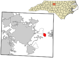
Altamahaw is a census-designated place (CDP) in Alamance County, North Carolina, United States. It is part of the Burlington, North Carolina Metropolitan Statistical Area. As of the 2010 census it had a population of 347. The community was listed as Altamahaw-Ossipee at the 2000 census, at which time the population was 996. The town of Ossipee incorporated in 2002 and currently has a population of 543. The remainder of the territory was reassigned as the Altamahaw CDP.

<span class="mw-page-title-main">Graham, North Carolina</span> City in North Carolina, United States

Graham is a city in Alamance County, North Carolina, United States. It is part of the Burlington, North Carolina Metropolitan Statistical Area. As of the 2020 census the population was 17,153. It is the county seat of Alamance County.

<span class="mw-page-title-main">Green Level, North Carolina</span> Town in North Carolina, United States

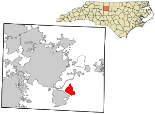
Green Level is a town in Alamance County, North Carolina, United States. It is part of the Burlington, North Carolina Metropolitan Statistical Area. As of the 2020 census, the population was 3,156.

<span class="mw-page-title-main">Swepsonville, North Carolina</span> Town in North Carolina, United States

Swepsonville is a town in Alamance County, North Carolina, United States. It is part of the Burlington, North Carolina Metropolitan Statistical Area. The population at the 2010 census was 1,154.

<span class="mw-page-title-main">Rural Hall, North Carolina</span> Town in North Carolina, United States

Rural Hall is a town in Forsyth County, North Carolina, United States. It is a part of the Piedmont Triad. The population was 3,360 at the 2020 census. The town has one public park: Covington Memorial Park.

<span class="mw-page-title-main">Forest Oaks, North Carolina</span> Census-designated place in North Carolina, United States

Forest Oaks is a census-designated place (CDP) in Guilford County, North Carolina, United States. The population was 3,890 as of the 2010 census, up from 3,241 in 2000.

<span class="mw-page-title-main">McLeansville, North Carolina</span> Census-designated place in North Carolina, United States

McLeansville is an unincorporated community and census-designated place (CDP) in Guilford County, North Carolina, United States. The population was 1,021 at the 2010 census.

<span class="mw-page-title-main">Oak Ridge, North Carolina</span> Town in North Carolina, United States

Oak Ridge is a town in northwestern Guilford County, North Carolina, United States. The population was 6,185 at the 2010 census, up from 3,988 in 2000. As of 2018, the population had risen to an estimated 6,977. Oak Ridge is 15 miles (24 km) northwest of the center of Greensboro, North Carolina's third-most populous city, and it is a part of the Piedmont Triad urban area.

<span class="mw-page-title-main">Pleasant Garden, North Carolina</span> Town in North Carolina, United States

Pleasant Garden is a town in Guilford County, North Carolina, United States. The population was 4,489 at the 2010 census.

<span class="mw-page-title-main">Stokesdale, North Carolina</span> Town in North Carolina, United States

Stokesdale is a town in Guilford County with a small part in Rockingham County, North Carolina, United States. The population was 5,924 at the 2020 census. Belews Lake is located nearby, and North Carolina Highway 68 and North Carolina Highway 65 both intersect U.S. Route 158 near the town's center.

<span class="mw-page-title-main">Summerfield, North Carolina</span> Town in North Carolina, United States

Summerfield is a town in Guilford County, North Carolina. The population was 7,018 at the 2000 census. At the 2010 census, the population had risen to 10,232.

<span class="mw-page-title-main">Whitsett, North Carolina</span> Town in North Carolina, United States

Whitsett is a town in Guilford County, North Carolina, United States. The population was 590 at the 2010 census.

<span class="mw-page-title-main">Midway, Ohio</span> Village in Ohio, United States

Midway is a village in Range Township, Madison County, Ohio, United States. The population was 269 at the 2020 census.

<span class="mw-page-title-main">Burlington, Wyoming</span> Town in Wyoming, United States

Burlington is a town in Big Horn County, Wyoming, United States. The population was 288 at the 2010 census.

<span class="mw-page-title-main">Gibsonville, North Carolina</span> Town in North Carolina, United States

Gibsonville is a town in both Alamance and Guilford counties in the U.S. state of North Carolina. Most of Gibsonville is situated in the Greensboro-Winston-Salem-High Point Combined Statistical Area and the eastern portion is in the Burlington, North Carolina Metropolitan Statistical Area, encompassing all of Alamance County. According to the 2020 census, the population of Gibsonville was 8,971.

<span class="mw-page-title-main">Guilford (CDP), Maine</span> CDP in Maine, United States

Guilford is a census-designated place (CDP) in the town of Guilford in Piscataquis County, Maine, United States. The population was 945 at the 2000 census.

<span class="mw-page-title-main">Guilford, Maine</span> Town in the state of Maine, United States

Guilford is a town in Piscataquis County, Maine, United States. The town is located on the Piscataquis River and was first settled in 1806. The population was 1,267 at the time of the 2020 census.

References

  1. "ArcGIS REST Services Directory". United States Census Bureau. Retrieved September 20, 2022.
  2. 1 2 U.S. Geological Survey Geographic Names Information System: Sedalia, North Carolina
  3. 1 2 "U.S. Census website". United States Census Bureau . Retrieved January 31, 2008.
  4. 1 2 "Geographic Identifiers: 2010 Demographic Profile Data (G001): Sedalia town, North Carolina". American Factfinder. U.S. Census Bureau. Retrieved January 11, 2017.[ dead link ]
  5. "National Register Information System". National Register of Historic Places . National Park Service. July 9, 2010.
  6. "Census of Population and Housing". Census.gov. Retrieved June 4, 2015.