Senerchia

Last updated
Senerchia
Comune di Senerchia
Senerchia.jpg
Location of Senerchia
Senerchia
Italy provincial location map 2016.svg
Red pog.svg
Senerchia
Location of Senerchia in Italy
Italy Campania location map.svg
Red pog.svg
Senerchia
Senerchia (Campania)
Coordinates: 40°44′30″N15°12′15″E / 40.74167°N 15.20417°E / 40.74167; 15.20417 Coordinates: 40°44′30″N15°12′15″E / 40.74167°N 15.20417°E / 40.74167; 15.20417
Country Italy
Region Campania
Province Province of Avellino
Frazioni Saperoni, Acquabianca, Cervaro, Maglio
Government
  MayorBeniamino Grillo (Unione di Centro, UDC)
Area
[1]
  Total36 km2 (14 sq mi)
Elevation
600 m (2,000 ft)
Highest elevation
1,803 m (5,915 ft)
Lowest elevation
161 m (528 ft)
Population
 (2011) [2]
  Total1,036
  Density29/km2 (75/sq mi)
Demonym(s) Senerchiesi
Time zone UTC+1 (CET)
  Summer (DST) UTC+2 (CEST)
Postal code
83050
Dialing code 0827
ISTAT code 064098
Patron saintSt. Michael the Archangel
Saint day29 September
Website Official website

Senerchia (Sinerchia in the local dialect) is an Italian municipality with 1370 registered voters, but only 1036 inhabitants, in the Province of Avellino, located in the upper valley of the Sele River in Campania. It was the site of the defeat of Spartacus and is noted for the ruins of an ancient castle.

Contents

Geography

Senerchia mainly borders the Province of Salerno, and it is surrounded by the Picentini Mountains. Its main road links it to the town of Quaglietta.

Senerchia borders the municipalities of Acerno (SA), Campagna (SA), Oliveto Citra (SA), Valva (SA) and Calabritto, the only neighbouring municipality in the same province.

The village is located 600 metres (2,000 ft) above sea level in the High Sele Valley, in a hilly area on the eastern side of the Picentini Mountains, at the foot of the steep slopes of Mount Boschetiello. The territory is composed of forests and mountains, including many peaks over 1,500 metres (4,900 ft) above sea level, such as Mount Boschetiello at 1,574 metres (5,164 ft), Mount Croce at 1,533 metres (5,030 ft), Raia della Volpe at 1,631 metres (5,351 ft), Sierro dei Cuoppi at 1,683 metres (5,522 ft), Sierro della Pica at 1,536 metres (5,039 ft) and Raia del Pastore at 1,524 metres (5,000 ft). The hilly terrain starts at 600 metres (2,000 ft) and continues down the country on the right bank of the river Sele. The territory is full of springs and landslide soil. In addition to the Sele, which skirts the municipal area, other waterways include the Vallone Forma, Piceglia, Fiumicello Rovivo, Pozzo San Nicola and Acquabianca.

Following the Irpinia earthquake of 1980, Senerchia has undergone a radical urban transformation. The village was completely destroyed. The old part has been abandoned and dangerous buildings are clearly visible. There is now a green area where the main square and the church were destroyed by a landslide. New buildings have been built beside the old site, with new urbanization and wide streets.

History

Origins

Senerchia originated as a group of remote, pre-Roman settlements. The first settlement was positioned on the heights where the ruins of the castle currently stand, almost forming a fortified town. The ruins of the castle are located in the upper part of the old village, near the church of the town's patron saint, Saint Michael the Archangel. This hill, a spur of Mount Boschetiello, overlooks the High Sele Valley.

The name "Senerchia" is derived from "Sena Herclae," which means "Bosom of Hercules" in archaic Latin. The etymology of the word and the castle ruins may indicate that Senerchia was once strong and powerful. Some also say that[ who? ], the name recalls the local Northern Tuscan names silerchia and silerchie which presuppose a "silercula" from the Latin Siler-eris, meaning a plant that grows in places full of water.

Spartacus

The final battle that saw the defeat and death of Spartacus in 71 BC took place in the present-day territory of Senerchia, on a site on the right bank of the river Sele in an area that includes the border with Oliveto Citra up to Calabritto, near the village of Quaglietta. At the time of the battle this territory was part of Lucania. There have been numerous recent finds of armour and swords dating back to the Roman Empire.

Spartacus and his army of slaves were marching toward Apulia to set sail for Thrace when Crassus, who was at the head of a well-armed Roman army, attacked from behind. Spartacus, partially due to the weariness of his men, wanted to take the battle to the Romans. Spartacus killed his horse, saying that if he won he would have all the horses he wanted, but if he lost he would not be tempted to run away. Spartacus was at the front of the attack, where he died after first killing some Roman soldiers. Some detachments of his army fled and scattered over the surrounding mountains.[ citation needed ]

Sinerchia family

The Sinerchia family was mentioned in the Catalogus Baronum of 1150–1168.

Scipione Ammirato (1531–1601) described Senerchia as "a castle in the Principality of Salerno of 160 hearths, which has given its name to the family that has owned it for over three hundred years", referring to the Sinerchia family whose history was so closely linked to the estate. The Sinerchias were an ancient noble family of Norman origin, derived from the Filangieri. They took part in many feuds between Campania, Basilicata, and Apulia, and lived mainly between Senerchia and Naples until the fifteenth century. The Sinerchia, transplanted later to the Basilicata region, were honored with the title of Count in the fifteenth century, and following the 1481 Conspiracy of the Barons assumed the surname of Scardaccione. Orlando Sinerchia Scardaccione, Count of Sant’Andrea, when he moved to Potenza, together with his cousin Amelio, was deprived of his estates as a consequence of the Conspiracy of the Barons.

Castle

The castle of Senerchia, overlooking the High Sele Valley, had ancient origins. It may already have been the defensive garrison of Irpini, and the Romans probably had to work hard to subdue it; hence the Latin name Sena Herclea (which means Bosom of Hercules). It was strengthened under the control of the Byzantines in the final war against the Goths. The Lombards changed the fortifications and made further extensions. In the Angevin period of Senerchia, Nicholas was keeper in 1271, commissioned by Charles I of Anjou. The keep, with only its west front still well preserved, is one of the few survivors of the ancient fortified complex.

Related Research Articles

Lucania ancient district of southern Italy

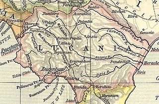
Lucania was a historical region of Southern Italy. It was the land of the Lucani, an Oscan people. It extended from the Tyrrhenian Sea to the Gulf of Taranto.

Province of Avellino Province of Italy

The Province of Avellino is a province in the Campania region of Southern Italy. The area is characterized by numerous small towns and villages scattered across the province; only two towns have a population over 20,000: its capital city Avellino and Ariano Irpino.

Accettura Comune in Basilicata, Italy

Accettura is a town and comune in the province of Matera, in the Southern Italian region of Basilicata. It is bounded by the comuni of Calciano, Campomaggiore, Cirigliano, Oliveto Lucano, Pietrapertosa, San Mauro Forte and Stigliano.

Altavilla Silentina Comune in Campania, Italy

Altavilla Silentina is a town and comune located in the province of Salerno, Campania, some 100 km south of Naples, Italy.

Campagna Comune in Campania, Italy

Campagna is a small town and comune of the province of Salerno, in the Campania region of Southern Italy. Its population is 17,148. Its old latin name was Civitas Campaniae. Campagna is located in one of the Picentini Mountains valleys at an altitude of 270 meters above sea level.

Ofanto river in Italy

The Ofanto, known in ancient times as Aufidus or Canna, is a 170-kilometre (110 mi) river in southern Italy that flows through the regions of Campania, Basilicata, and Apulia, into the Gulf of Manfredonia near Barletta.

Sele (river) river in Italy

The Sele is a river in southwestern Italy. Originating from the Monti Picentini in Caposele, it flows through the region of Campania, in the provinces of Salerno and Avellino. Its mouth is in the Gulf of Salerno, on the Tyrrhenian Sea, at the borders between the municipalities of Eboli and Capaccio, in the beginning point of Cilentan Coast.

Savignano Irpino Comune in Campania, Italy

Savignano Irpino is a village and comune in the province of Avellino, in the Campania region of southern Italy.

Eboli Comune in Campania, Italy

Eboli is a town and comune of Campania, southern Italy, in the province of Salerno.

The Hirpini were an ancient Samnite tribe of Southern Italy. While generally regarded as having been Samnites, sometimes they are treated as a distinct and independent nation. They inhabited the southern portion of Samnium, in the more extensive sense of that name, roughly the area now known as Irpinia from their name—a mountainous region bordering on Basilicata towards the south, on Apulia to the east, and on Campania towards the west. No marked natural boundary separated them from these neighboring nations, but they occupied the lofty masses and groups of the central Apennines, while the plains on each side, and the lower ranges that bounded them, belonged to their more fortunate neighbors. The mountain basin formed by the three tributaries of the Vulturnus —the Tamarus, Calor, and Sabatus, which, with their valleys, unite near Beneventum, surrounded on all sides by lofty and rugged ranges of mountains—is the center and heart of their territory. Its more southern portion comprised the upper valley of the Aufidus and the lofty group of mountains where that river takes its rise.

Acerno Comune in Campania, Italy

Acerno, is a town and comune in the province of Salerno in the region of Campania in south-western Italy.

Calabritto Comune in Campania, Italy

Calabritto is an Italian town and a commune in the province of Avellino, Campania, Italy. It occupies a hilly-mountainous area at the eastern tip of the Monti Picentini range.

Calitri Comune in Campania, Italy

Calitri is a town and comune in the province of Avellino, Campania, Italy.

Lioni Comune in Campania, Italy

Lioni is a town and comune in the province of Avellino, Campania, southern Italy.

Battipaglia Comune in Campania, Italy

Battipaglia is a town and a comune in the province of Salerno, in the Campania region of south-western Italy.

Oliveto Citra Comune in Campania, Italy

Oliveto Citra is a town and comune in the province of Salerno in the Campania region of south-western Italy. It is located 55 kilometres (34 mi) by road northeast of Salerno. As of 2016, the comune had 3,802 inhabitants and covered an area of 31.62 square kilometres (12.21 sq mi).

Valva, Campania Comune in Campania, Italy

Valva is an Italian town and municipality in the Province of Salerno in the south-western region of Campania.

Anzano di Puglia Comune in Apulia, Italy

Anzano di Puglia is a small town and comune in the province of Foggia and region of Apulia in southeast Italy. It rises 760 metres (2,490 ft) above sea level.

Irpinia historical-geographical district in Southern Italy

Irpinia is a district of the Apennine Mountains around Avellino, a town in Campania, South Italy, about 50 km east of Naples. It was the territory of the ancient Hirpini tribe; its extent matches approximately today's province of Avellino.

Spartacus Thracian gladiator

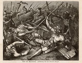
Spartacus was a Thracian gladiator who, along with Crixus, Gannicus, Castus, and Oenomaus, was one of the escaped slave leaders in the Third Servile War, a major slave uprising against the Roman Republic. Little is known about him beyond the events of the war, and surviving historical accounts are sometimes contradictory and may not always be reliable. However, all sources agree that he was a former gladiator and an accomplished military leader.

References

  1. "Superficie di Comuni Province e Regioni italiane al 9 ottobre 2011". Istat. Retrieved 16 March 2019.
  2. "Popolazione Residente al 1° Gennaio 2018". Istat. Retrieved 16 March 2019.