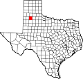
Seth Ward, Texas

Last updated

Seth Ward, Texas
TXMap-doton-Plainview.PNG
Location of Seth Ward, Texas
Hale County SethWard.svg
Coordinates: 34°12′45″N101°41′46″W / 34.21250°N 101.69611°W / 34.21250; -101.69611
Country United States
State Texas
County Hale
Area
  Total2.2 sq mi (5.8 km2)
  Land2.2 sq mi (5.8 km2)
  Water0.0 sq mi (0.0 km2)
Elevation
3,373 ft (1,028 m)
Population
 (2020)
  Total1,603
  Density720/sq mi (280/km2)
Time zone UTC-6 (Central (CST))
  Summer (DST) UTC-5 (CDT)
FIPS code 48-66848 [1]
GNIS feature ID1367965 [2]

Seth Ward is an unincorporated community and census-designated place (CDP) in Hale County, Texas, United States. The population was 2,025 at the 2010 census. [3]

Contents

History

It is named for Seth Ward College, which was founded in 1910 by Methodist bishop Seth Ward, who took over Central Plains College and Conservatory of Music (founded in 1907) to form Seth Ward College. The school burned in 1916 and was not rebuilt. [4]

Country singer Jimmy Dean was born in Seth Ward. [5]

Geography

Seth Ward is located in northeastern Hale County at 34°12′45″N101°41′46″W / 34.21250°N 101.69611°W / 34.21250; -101.69611 (34.212421, -101.696088). [6] It is bordered to the southwest by the city of Plainview, the county seat. Interstate 27 passes just north of Seth Ward, with access from Exit 53. I-27 leads north 74 miles (119 km) to Amarillo and south 50 miles (80 km) to Lubbock.

According to the United States Census Bureau, the CDP has a total area of 2.2 square miles (5.8 km2), all of it land. [3]

Demographics

Historical population
CensusPop.Note
2020 1,603
U.S. Decennial Census [7]
1850–1900 [8] 1910 [9]
1920 [10] 1930 [11] 1940 [12]
1950 [13] 1960 [14] 1970 [15]
1980 [16] 1990 [17] 2000 [18]
2010 [19]

2020 census

Seth Ward racial composition [20]
(NH = Non-Hispanic) [lower-alpha 1]
RaceNumberPercentage
White (NH)29418.34%
Black or African American (NH)110.69%
Native American or Alaska Native (NH)50.31%
Pacific Islander (NH)10.06%
Mixed/Multi-Racial (NH)181.12%
Hispanic or Latino 1,27479.48%
Total1,603

As of the 2020 United States census, there were 1,603 people, 509 households, and 387 families residing in the CDP.

2000 census

As of the census [1] of 2000, there were 1,926 people, 586 households, and 467 families residing in the CDP. The population density was 1,198.7 inhabitants per square mile (462.8/km2). There were 693 housing units at an average density of 431.3 per square mile (166.5/km2). The racial makeup of the CDP was 60.02% White, 3.63% African American, 1.04% Native American, 0.05% Asian, 32.76% from other races, and 2.49% from two or more races. Hispanic or Latino of any race were 64.07% of the population.

There were 586 households, out of which 48.8% had children under the age of 18 living with them, 56.0% were married couples living together, 16.0% had a female householder with no husband present, and 20.3% were non-families. 16.7% of all households were made up of individuals, and 6.0% had someone living alone who was 65 years of age or older. The average household size was 3.29 and the average family size was 3.69.

In the CDP, the population was spread out, with 38.0% under the age of 18, 9.8% from 18 to 24, 27.9% from 25 to 44, 15.4% from 45 to 64, and 8.9% who were 65 years of age or older. The median age was 27 years. For every 100 females, there were 91.5 males. For every 100 females age 18 and over, there were 99.0 males.

The median income for a household in the CDP was $24,167, and the median income for a family was $28,000. Males had a median income of $22,152 versus $18,583 for females. The per capita income for the CDP was $9,663. About 19.2% of families and 25.7% of the population were below the poverty line, including 28.9% of those under age 18 and 44.5% of those age 65 or over.

Education

Seth Ward is served by the Plainview Independent School District.

Related Research Articles

<span class="mw-page-title-main">Lakehills, Texas</span> CDP in Texas, United States

Lakehills is a census-designated place (CDP) in Bandera County, Texas, United States. The population was 5,295 at the 2020 census, making it the most populous place in Bandera County. It is part of the San Antonio Metropolitan Statistical Area.

<span class="mw-page-title-main">Circle D-KC Estates, Texas</span> CDP in Texas, United States

Circle D-KC Estates is a census-designated place (CDP) in Bastrop County, Texas, United States. The population was 2,588 at the 2020 census.

<span class="mw-page-title-main">Cross Mountain, Texas</span> Census-designated place in Texas, United States

Cross Mountain is a census-designated place (CDP) in Bexar County, Texas, United States. The population was 3,944 at the 2020 census, an increase over the figure of 3,124 tabulated in 2010. It is part of the San Antonio Metropolitan Statistical Area.

<span class="mw-page-title-main">Scenic Oaks, Texas</span> Census-designated place in Texas, United States

Scenic Oaks is a census-designated place (CDP) in Bexar County, Texas, United States. It is part of the San Antonio Metropolitan Statistical Area. The population was 10,458 at the 2020 census, up from 4,957 at the 2010 census.

<span class="mw-page-title-main">Lake Brownwood, Texas</span> Census-designated place in Texas, United States

Lake Brownwood is a census-designated place (CDP) located in Brown County in central Texas, United States. The population was 1,532 at the 2010 census.

<span class="mw-page-title-main">Cameron Park, Texas</span> CDP in Texas, United States

Cameron Park is a census-designated place (CDP) in Cameron County, Texas, United States. The population was 6,099 at the 2020 census. It is part of the Brownsville–Harlingen Metropolitan Statistical Area.

<span class="mw-page-title-main">Homestead Meadows South, Texas</span> Census-designated place in Texas, United States

Homestead Meadows South is a census-designated place (CDP) in El Paso County, Texas, United States. The population was 7,247 at the 2010 census. It is part of the El Paso Metropolitan Statistical Area.

<span class="mw-page-title-main">Stonewall, Texas</span> Census-designated place in Texas, United States

Stonewall is an unincorporated community and census-designated place (CDP) in Gillespie County, Texas, United States. The population was 451 at the 2020 census. It was named for Confederate General Thomas J. (Stonewall) Jackson, by Israel P. Nunez, who established a stage station near the site in 1870.

<span class="mw-page-title-main">Redwood, Texas</span> Unincorporated community in Texas, United States

Redwood is an unincorporated community and census-designated place (CDP) in Guadalupe County, Texas, United States. The population was 4,003 at the 2020 census, a decline from the figure of 4,338 tabulated in 2010. It is part of the San Antonio Metropolitan Statistical Area.

<span class="mw-page-title-main">Barrett, Texas</span> Census-designated place in Texas, United States

Barrett, also named Barrett Station, is an unincorporated community and census-designated place (CDP) in Harris County, Texas, United States. The population was 5,223 at the 2020 census. It was founded in 1889 by Harrison Barrett, a former slave.

<span class="mw-page-title-main">Oak Trail Shores, Texas</span> Census-designated place in Texas, United States

Oak Trail Shores is an unincorporated community and census-designated place (CDP) in Hood County, Texas, United States. Its population was 2,755 at the 2010 census. It is part of the Granbury micropolitan area as well as the Dallas–Fort Worth metroplex.

<span class="mw-page-title-main">Buna, Texas</span> Census-designated place in Texas, United States

Buna is an unincorporated community and census-designated place (CDP) in Jasper County, Texas, United States. The population was 2,137 at the 2020 census.

<span class="mw-page-title-main">Central Gardens, Texas</span> Census-designated place in Texas, United States

Central Gardens is an unincorporated community and census-designated place (CDP) in Jefferson County, Texas, United States. The population was 4,373 at the 2020 census. It is part of the Beaumont–Port Arthur metropolitan area.

<span class="mw-page-title-main">Lipscomb, Texas</span> Census-designated place in Texas, United States

Lipscomb is an unincorporated community and census-designated place (CDP) in Lipscomb County, Texas, United States. It is the Lipscomb county seat. The population was 66 at the 2020 census.

<span class="mw-page-title-main">El Indio, Texas</span> Census-designated place in Maverick County, Texas, United States

El Indio is a census-designated place (CDP) in Maverick County, Texas, United States. The population was 263 at the 2000 census.

<span class="mw-page-title-main">Deweyville, Texas</span> CDP in Texas, United States

Deweyville is a census-designated place (CDP) in Newton County, on the central eastern border of Texas, United States. The population was 571 at the 2020 census, down from 1,023 at the 2010 census.

<span class="mw-page-title-main">Falcon Village, Texas</span> CDP in Texas, United States

Falcon Village is a census-designated place (CDP) in Starr County, Texas, United States. The population was 3 at the 2020 census.

<span class="mw-page-title-main">La Victoria, Texas</span> CDP in Texas, United States

La Victoria is a census-designated place (CDP) in Starr County, Texas, United States. La Victoria underwent some changes prior to the 2010 census. It gained area, had portions taken to form new CDPs, and lost additional area. Only a small part of 2010 La Victoria CDP was within the 2000 La Victoria CDP. The population was only 171 at the 2010 census, a decline from the figure of 1,683 tabulated at the 2000 census.

<span class="mw-page-title-main">San Isidro, Texas</span> CDP in Texas, United States

San Isidro is a census-designated place (CDP) in Starr County, Texas, United States. The population was 240 at the 2010 census. The town is named for St. Isidore the Laborer, the patron saint of farmers. A large Southwestern Barrel Cactus growing just east of town is said to be the largest in Texas.

<span class="mw-page-title-main">Inez, Texas</span> CDP in Texas, United States

Inez is a census-designated place (CDP), on Interstate 69/U.S. Highway 59, fifteen miles northeast of Victoria, near the Jackson County, Texas line in Victoria County, Texas, United States. The population was 2,098 at the 2010 census. It is included in the Victoria, Texas, Metropolitan Statistical Area. The name is that of a daughter of a railroad developer.

References

  1. 1 2 "U.S. Census website". United States Census Bureau . Retrieved January 31, 2008.
  2. "US Board on Geographic Names". United States Geological Survey. October 25, 2007. Retrieved January 31, 2008.
  3. 1 2 "Geographic Identifiers: 2010 Census Summary File 1 (G001): Seth Ward CDP, Texas". American Factfinder. U.S. Census Bureau. Archived from the original on February 13, 2020. Retrieved February 2, 2018.
  4. Seth Ward, Texas profile - tshaonline.com
  5. Weber, Bruce (June 14, 2010). "Jimmy Dean, Singer and Businessman, Dies at 81". The New York Times . Archived from the original on October 3, 2017. Retrieved June 14, 2010. Jimmy Ray Dean was born in Seth Ward, just outside Plainview, at the base of the Texas panhandle, on Aug. 10, 1928.
  6. "US Gazetteer files: 2010, 2000, and 1990". United States Census Bureau. February 12, 2011. Retrieved April 23, 2011.
  7. "Decennial Census by Decade". US Census Bureau.
  8. "1900 Census of Population - Population of Texas By Counties And Minor Civil Divisions" (PDF). United States Census Bureau .
  9. "1910 Census of Population - Supplement for Texas" (PDF). United States Census Bureau .
  10. "1920 Census of Population - Number of Inhabitants - Texas" (PDF). United States Census Bureau .
  11. "1930 Census of Population - Number of Inhabitants - Texas" (PDF). United States Census Bureau .
  12. "1940 Census of Population - Number of Inhabitants - Texas" (PDF). United States Census Bureau .
  13. "1950 Census of Population - Number of Inhabitants - Texas" (PDF). United States Census Bureau .
  14. "1960 Census of Population - Number of Inhabitants - Texas" (PDF). United States Census Bureau .
  15. "1970 Census of Population - Number of Inhabitants - Texas" (PDF). United States Census Bureau .
  16. "1980 Census of Population - Number of Inhabitants - Texas" (PDF). United States Census Bureau .
  17. "1990 Census of Population - Population and Housing Unit Counts - Texas" (PDF). United States Census Bureau .
  18. "2000 Census of Population - Population and Housing Unit Counts - Texas" (PDF). United States Census Bureau .
  19. "2010 Census of Population - Population and Housing Unit Counts - Texas" (PDF). United States Census Bureau .
  20. "Explore Census Data". data.census.gov. Retrieved May 20, 2022.
  21. https://www.census.gov/ [ not specific enough to verify ]
  22. "About the Hispanic Population and its Origin". www.census.gov. Retrieved May 18, 2022.
  1. Note: the US Census treats Hispanic/Latino as an ethnic category. This table excludes Latinos from the racial categories and assigns them to a separate category. Hispanics/Latinos can be of any race. [21] [22]