Related Research Articles

Templeville is a town in Caroline and Queen Anne's counties, Maryland, United States. Templeville is located near the Maryland-Delaware line. The population was 138 at the 2010 census. It was known as Bullock Town until the name was changed in 1847. The name Templeville derives from the Temple family, whose most famous member was Governor William Temple of Delaware.
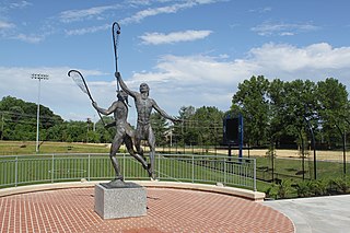
The National Lacrosse Hall of Fame and Museum, is located in Sparks, Maryland at the USA Lacrosse headquarters. Prior to moving to its present location in 2016, the hall of fame and museum was located in Baltimore, Maryland, on the Homewood campus of Johns Hopkins University. The museum showcases the history of the game of lacrosse, from its Native American origins to its present-day form.
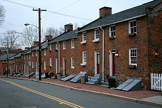
Oella is a mill town on the Patapsco River in western Baltimore County, Maryland, United States, located between Catonsville and Ellicott City. It is a 19th-century village of millworkers' homes.

The Toyota Coliseum, formerly the State Fair Coliseum, is an indoor arena in Geddes, New York. It hosted the Syracuse Nationals from 1946 to 1951 as well as the Syracuse Stars of the American Hockey League. It also served as a temporary home to the Syracuse Orange men's basketball team following the burning of their on-campus gymnasium, Archbold Gymnasium, in 1947 until the opening of the Onondaga County War Memorial in 1951. The arena held 7,500 people and was built in 1927. It is owned by the State of New York under the Great New York State Fair. After undergoing renovations, the seating capacity was reduced to 3,600 and is now primarily used for horse shows. Much of the previous infrastructure, including the scoreboard and announcers booth, are still in place.
Conowingo Creek is a 20.2-mile-long (32.5 km) tributary of the Susquehanna River in Lancaster County, Pennsylvania and Cecil County, Maryland.
Moxahala is an unincorporated community in northern Pleasant Township, Perry County, Ohio, United States. It has a post office with the ZIP code 43761. State Route 13 runs through Moxahala, connecting it with New Lexington to the northwest and Rendville to the southeast.
The Baltimore City District Courthouses of the District Court of Maryland are located at North Avenue, Wabash Avenue, Patapsco Avenue and E. Fayette Street in Baltimore, Maryland, and serve as the courts of first impression for the majority of residents in Baltimore City.

Hillen is a small community just west of Hillen Road and Morgan State University and south of Coldspring Lane in Baltimore, Maryland, United States.
General's Highway Corridor Park is located at 1758 Crownsville Road, in the town of Crownsville, Maryland, United States. It is located near the site of the annual Maryland Renaissance Festival in the heart of Anne Arundel County.
Morgan Run Natural Environment Area is a protected area in Carroll County, Maryland. Located on 1,930 acres (7.8 km2), Morgan Run features hiking and equestrian trails, catch and release trout fishing, and deer hunting.
Stoney Demonstration Forest is a state forest located in Aberdeen, Maryland, United States.
Woodbine is an unincorporated community in York County, Pennsylvania, United States. Until 1978, this community was served by the Maryland and Pennsylvania Railroad at milepost 50.6.
Overlea is a neighborhood in northeast Baltimore. It is home to the Maryland School for the Blind.

Gwynn's Falls is a neighborhood in the Southwestern District of Baltimore, located between Irvington (west) and Gwynns Falls Leakin Park (east). Frederick Avenue marks the neighborhood's boundary to the north; Wilkens Avenue draws its southern edge. Caton Avenue separates it from Irvington to the west.
The Orchards is a neighborhood in the North District of Baltimore, located between the neighborhoods of New North Roland Park–Poplar Hill and Bellona–Gittings. Its boundaries are marked by the Baltimore County line (north), Maryland Route 133 Northern Parkway (south), and Maryland Route 139 Charles Street (east). Roland Avenue, West Lake Avenue, Kenmore Road and Melrose Avenue draw the neighborhood's west boundary.
Morgan Park is a neighborhood in Baltimore, Maryland, located immediately east of Morgan State University.
The David Force Natural Resource Area is a 221-acre (89 ha) wildlife area in Ellicott City, Maryland. It is located between Route 70 and 40 adjacent to the Turf Valley development in Howard County, Maryland, and operated by the Howard County Department of Recreation and Parks.
Liberty Square is a neighborhood in Baltimore, Maryland. African Americans make up the vast majority of residents.
Arney is an unincorporated community in eastern Jefferson Township, Owen County, in the U.S. state of Indiana. It lies near the intersection of County Road 880 West and County Road 500 South, which is a community nearly ten miles southwest of the city of Spencer, the county seat of Owen County. Its elevation is 705 feet, and it is located at 39°13′7″N86°55′54″W.
Concord Hill is an unincorporated community in Warren County, in the U.S. state of Missouri.
References
- ↑ "Geographic Names Information System". Sharpstown (Populated Place). U.S. Geological Survey. 2009-01-29.
Municipalities and communities of Kent County, Maryland, United States | ||
|---|---|---|
| Towns |  | |
| CDPs | ||
| Unincorporated communities | ||
| Footnotes | ‡This populated place also has portions in an adjacent county or counties | |
Coordinates: 39°08′11″N76°13′07″W / 39.13639°N 76.21861°W