Lynch, Maryland

Last updated
Lynch, Maryland
USA Maryland location map.svg
Red pog.svg
Lynch
Coordinates: 39°17′43″N76°03′46″W / 39.29528°N 76.06278°W / 39.29528; -76.06278 Coordinates: 39°17′43″N76°03′46″W / 39.29528°N 76.06278°W / 39.29528; -76.06278
Country Flag of the United States.svg United States
State Flag of Maryland.svg  Maryland
County Flag of Kent County, Maryland.gif Kent
Elevation
75 ft (23 m)
Time zone UTC-5 (Eastern (EST))
  Summer (DST) UTC-4 (EDT)
ZIP code
21678
Area code(s) 410, 443, and 667
GNIS feature ID590713 [1]

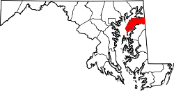
Lynch is an unincorporated community in Kent County, Maryland, United States. [1] Lynch is located along Maryland Route 561 at the crossing of the Maryland and Delaware Railroad, north of Chestertown.

Education

It is in the Kent County Public Schools. Kent County Middle School is in Chestertown, and Kent County High School is in an unincorporated area, in the Butlertown census-designated place with a Worton postal address.

The community was formerly assigned to Worton Elementary School. [2] In 2017 the school board voted to close Worton Elementary. The boundary of Garnet Elementary School in Chestertown was adjusted. [3]

Related Research Articles

<span class="mw-page-title-main">Kent County, Maryland</span> County in Maryland, United States

Kent County is a county located in the U.S. state of Maryland. As of the 2020 census, its population was 19,198, making it the least populous county in Maryland. Its county seat is Chestertown. The county was named for the county of Kent in England. The county is located on Maryland's Eastern Shore. It is one of three counties in Maryland, along with Caroline and Garrett, that is not part of a Metropolitan Statistical Area.

<span class="mw-page-title-main">Betterton, Maryland</span> Historic district in Maryland, United States

Betterton is a town in Kent County, Maryland, United States. The population was 345 at the 2010 census.

<span class="mw-page-title-main">Chestertown, Maryland</span> Town in Maryland, United States

Chestertown is a town in Kent County, Maryland, United States. The population was 5,252 as of the 2010 census. It is the county seat of Kent County.

<span class="mw-page-title-main">Galena, Maryland</span> Town in Maryland, United States

Galena is a town in Kent County, Maryland, United States. The population was 612 at the 2010 census.

<span class="mw-page-title-main">Rock Hall, Maryland</span> Town in Maryland, United States

Rock Hall, is a waterfront town located directly on the National Chesapeake Scenic Byway in Kent County, Maryland, United States. The population was 1,310 at the 2010 census.

<span class="mw-page-title-main">Millington, Maryland</span> Town in Maryland, United States

Millington is a town in Kent and Queen Anne's counties in the U.S. state of Maryland. The population was 642 at the 2010 census. Millington is the head of navigation for the Chester River.

<span class="mw-page-title-main">Philip Reed (politician)</span> American politician

Philip Reed was a United States Senator representing Maryland from 1806 to 1813.

Georgetown is an unincorporated community in northeastern Kent County, Maryland, United States. The community was laid out in 1736. Georgetown was named for Prince George who later became King of the United Kingdom. Georgetown is located on the south side of the Sassafras River at the Maryland Route 213 bridge, north of Galena and south of Cecilton. Directly to the north across the river is the unincorporated community of Fredericktown in Cecil County.

<span class="mw-page-title-main">Maryland Route 297</span>

Maryland Route 297 is a state highway in the U.S. state of Maryland. Known as Worton Road, the highway runs 3.59 miles (5.78 km) from MD 213 near Chestertown north to MD 298 in Butlertown in central Kent County. MD 297 was constructed in the late 1920s and reconstructed in the early 1970s. The highway from Butlertown to Newtown was part of MD 297 between 1942 and 1993.

<span class="mw-page-title-main">Abingdon, Maryland</span> Census-designated place in Maryland

Abingdon is a census-designated place in Harford County, Maryland, United States. It lies 25 miles (40 km) northeast of Baltimore on Maryland Route 7, near the Bush River, between Exits 77 and 80 of Interstate 95.

Still Pond is a census-designated place in Kent County, Maryland, United States. Still Pond is located at the intersection of Maryland routes 292 and 566 on Still Pond Neck, south-southeast of Betterton and north of Chestertown. Much of the community is included in the Still Pond Historic District and it is notable as the first place in Maryland in which women gained the right to vote.

Worton is an unincorporated community and census-designated place (CDP) in Kent County, Maryland, United States. As of the 2010 census it had a population of 249.

<span class="mw-page-title-main">Kennedyville, Maryland</span> Census-designated place in Maryland, United States

Kennedyville is an unincorporated community and census-designated place in Kent County, Maryland, United States. As of the 2010 census it had a population of 199.

<span class="mw-page-title-main">Chesterville, Maryland</span>

Chesterville is an unincorporated community in Kent County, Maryland, United States. It is located at the intersection of Maryland routes 290 and Maryland Route 447|447.

<span class="mw-page-title-main">Sassafras, Maryland</span>

Sassafras is an unincorporated community in Kent County, Maryland, United States. The Lanthim House, built in the 1720s, served as a general store.

Golts is an unincorporated community in Kent County, Maryland, United States. Golts is located at the intersection of Delaware Line Road and Black Bottom Road, east of Galena and west of the Delaware border.

Massey is an unincorporated community in Kent County, Maryland, United States. Massey is located at the intersection of Maryland routes 299, 313 and 330, southeast of Galena.

Butlertown is an unincorporated community and census-designated place in Kent County, Maryland, United States. Per the 2020 census, the population was 520.

Kent County High School (KCHS) is a public school located in Worton, Maryland in Kent County. It is the only high school within Kent County, is part of the Kent County Public Schools district, and serves students from ninth through twelfth grades. Trojans are the school mascot and the school colors are blue and gold. The student body is 2/3 white.

Kent County Public Schools (KCPS) is a school district headquartered in Rock Hall, Maryland. It operates public schools in Kent County, where it is the sole school district.

References

  1. 1 2 "Lynch". Geographic Names Information System . United States Geological Survey, United States Department of the Interior.
  2. "Welcome to our school!". Worton Elementary School. 2006-10-02. Archived from the original on 2006-10-02. Retrieved 2021-06-10.
  3. "Board of Education Action and Written Decision to Close Millington Elementary School and Worton Elementary School" (PDF). Kent County Public Schools. 2017-03-22. Retrieved 2021-06-10.