Edesville, Maryland | |
|---|---|
 Edesville  Edesville | |
| Coordinates: 39°09′18″N76°12′27″W / 39.15500°N 76.20750°W | |
| Country | |
| State | |
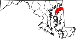
| County | |
| Area | |
• Total | 0.28 sq mi (0.74 km2) |
| • Land | 0.28 sq mi (0.71 km2) |
| • Water | 0.01 sq mi (0.02 km2) |
| Elevation | 26 ft (8 m) |
| Population (2020) | |
• Total | 169 |
| • Density | 612.32/sq mi (236.58/km2) |
| Time zone | UTC-5 (Eastern (EST)) |
| • Summer (DST) | UTC-4 (EDT) |
| ZIP code | 21661 [2] |
| Area codes | 410 & 443 |
| FIPS code | 24-24925 |
| GNIS feature ID | 590132 [3] |
Edesville is an unincorporated community and census-designated place in Kent County, Maryland, United States. [3] Its population was 169 as of the 2010 census. [4]