Tolchester Beach, Maryland

Last updated
Tolchester Beach, Maryland
USA Maryland location map.svg
Red pog.svg
Tolchester Beach
Usa edcp location map.svg
Red pog.svg
Tolchester Beach
Coordinates: 39°12′51″N76°14′41″W / 39.21417°N 76.24472°W / 39.21417; -76.24472 Coordinates: 39°12′51″N76°14′41″W / 39.21417°N 76.24472°W / 39.21417; -76.24472
Country Flag of the United States.svg United States
State Flag of Maryland.svg  Maryland
County Flag of Kent County, Maryland.gif Kent
Elevation
0 m (0 ft)
Time zone UTC-5 (Eastern (EST))
  Summer (DST) UTC-4 (EDT)
ZIP code
21620
Area code(s) 410, 443, and 667
GNIS feature ID595098 [1]

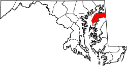
Tolchester Beach is an unincorporated community located on the eastern shore of the Chesapeake Bay in Kent County, Maryland, United States. Established in 1877, it was formerly a popular resort. [2] [3] [4] Tolchester Beach is located just north of Rock Hall. The resort was closed in 1962. [5]

Contents

In the late 1800s, Tolchester Beach was a popular tourist destination for residents of Baltimore and other areas served by the Chesapeake Bay steamships. [3] The beach had hotels, restaurants, games, picnics, horse-racing, and an amusement park with a merry-go-round and a roller coaster. [3]

Some of the steamships that served Tolchester Beach were the Emma Giles [6] and Louise. [3]

See also

Related Research Articles

<span class="mw-page-title-main">Maryland</span> U.S. state

Maryland is a state in the Mid-Atlantic region of the United States. It shares borders with Virginia, West Virginia, and the District of Columbia to its south and west; Pennsylvania to its north; and Delaware and the Atlantic Ocean to its east. Baltimore is the largest city in the state, and the capital is Annapolis. Among its occasional nicknames are Old Line State, the Free State, and the Chesapeake Bay State. It is named after Henrietta Maria, the French-born queen of England, Scotland, and Ireland, who was known then in England as Mary.

<span class="mw-page-title-main">Calvert County, Maryland</span> County in Maryland, United States

Calvert County is located in the U.S. state of Maryland. As of the 2010 census, the population was 88,737. Its county seat is Prince Frederick. The county's name is derived from the family name of the Barons of Baltimore, the proprietors of the English Colony of Maryland Calvert County is included in the Washington–Arlington–Alexandria, DC–VA–MD–WV Metropolitan Statistical Area. It occupies the Calvert Peninsula, which is bordered on the east by Chesapeake Bay and on the west by the Patuxent River. Calvert County is part of the Southern Maryland region. The county has one of the highest median household incomes in the United States.

<span class="mw-page-title-main">Kent County, Maryland</span> County in Maryland, United States

Kent County is a county located in the U.S. state of Maryland. As of the 2020 census, its population was 19,198, making it the least populous county in Maryland. Its county seat is Chestertown. The county was named for the county of Kent in England. The county is located on Maryland's Eastern Shore. It is one of three counties in Maryland, along with Caroline and Garrett, that is not part of a Metropolitan Statistical Area.

<span class="mw-page-title-main">Delmarva Peninsula</span> Large peninsula on the East Coast of the US

The Delmarva Peninsula, or simply Delmarva, is a large peninsula and proposed state on the East Coast of the United States, occupied by the vast majority of the state of Delaware and parts of the Eastern Shore regions of Maryland and Virginia. The peninsula is 170 miles (274 km) long. In width, it ranges from 70 miles (113 km) near its center, to 12 miles (19 km) at the isthmus on its northern edge, to less near its southern tip of Cape Charles. It is bordered by the Chesapeake Bay on the west, Pocomoke Sound on the southwest, and the Delaware River, Delaware Bay, and the Atlantic Ocean on the east.

<span class="mw-page-title-main">Fenwick Island, Delaware</span> Town in Delaware, United States

Fenwick Island is a coastal resort town in Sussex County, Delaware, United States. According to 2020 census figures, the population of the town is 355, a 2.6% decrease over the last decade. It is part of the Salisbury, Maryland-Delaware Metropolitan Statistical Area. The town is located on Fenwick Island, a barrier spit.

<span class="mw-page-title-main">Chesapeake Beach, Maryland</span> Town in Maryland

Chesapeake Beach is a town in Calvert County, Maryland, United States. Its major attractions include the Chesapeake Beach Railway Station, the Chesapeake Beach Rail Trail, a water park, marinas, piers, and charter boat fishing. The town's population was recorded as 5,753 in the 2010 census.

<span class="mw-page-title-main">Betterton, Maryland</span> Historic district in Maryland, United States

Betterton is a town in Kent County, Maryland, United States. The population was 345 at the 2010 census.

<span class="mw-page-title-main">Patuxent River</span> River in Maryland, United States

The Patuxent River is a tributary of the Chesapeake Bay in the state of Maryland. There are three main river drainages for central Maryland: the Potomac River to the west passing through Washington, D.C., the Patapsco River to the northeast passing through Baltimore, and the Patuxent River between the two. The 908-square-mile (2,352 km2) Patuxent watershed had a rapidly growing population of 590,769 in 2000. It is the largest and longest river entirely within Maryland, and its watershed is the largest completely within the state.

<span class="mw-page-title-main">Chesapeake Bay Bridge</span> Major dual-span bridge in the U.S. state of Maryland, spanning the Chesapeake Bay

The Chesapeake Bay Bridge is a major dual-span bridge in the U.S. state of Maryland. Spanning the Chesapeake Bay, it connects the state's rural Eastern Shore region with the urban Western Shore, between Stevensville and the capital city of Annapolis. The original span, opened in 1952 and with a length of 4.3 miles (6.9 km), was the world's longest continuous over-water steel structure. The parallel span was added in 1973. The bridge is officially named the Gov. William Preston Lane Jr. Memorial Bridge after William Preston Lane Jr. who, as the 52nd Governor of Maryland, initiated its construction in the late 1940s finally after decades of political indecision and public controversy.

<span class="mw-page-title-main">Kent Island (Maryland)</span> Largest Island and historic place in the Chesapeake Bay, United States

Kent Island is the largest island in the Chesapeake Bay and a historic place in Maryland. To the east, a narrow channel known as the Kent Narrows barely separates the island from the Delmarva Peninsula, and on the other side, the island is separated from Sandy Point, an area near Annapolis, by roughly four miles (6.4 km) of water. At only four miles wide, the main waterway of the bay is at its narrowest at this point and is spanned here by the Chesapeake Bay Bridge. The Chester River runs to the north of the island and empties into the Chesapeake Bay at Kent Island's Love Point. To the south of the island lies Eastern Bay. The United States Census Bureau reports that the island has 31.62 square miles (81.90 km2) of land area.

<span class="mw-page-title-main">Galesville, Maryland</span> Census-designated place in Maryland, United States

Galesville is an unincorporated town and census-designated place (CDP) in Anne Arundel County, Maryland, United States. As of the 2010 census, it had a population of 685.

<span class="mw-page-title-main">Maryland Route 445</span>

Maryland Route 445 is a state highway in the U.S. state of Maryland. The highway runs 11.96 miles (19.25 km) from Eastern Neck Island in the southwest corner of Kent County north to MD 21 near Tolchester Beach. MD 445 connects Tolchester Beach and Eastern Neck Island with Rock Hall, where the highway intersects MD 20. The first piece of MD 445 was constructed as part of MD 20 around 1920. The remainder of the highway was built around 1930. MD 445 was reconstructed in the mid-1960s and early to mid-1970s.

Arundel-on-the-Bay is a former post village and resort area in Anne Arundel County, Maryland, United States, located approximately 2 miles (3.2 km) southeast of Annapolis. Arundel-on-the-Bay is located on a peninsula known as the Annapolis Neck and is a peninsula in and of itself, bordered on the east and south by the Chesapeake Bay, and by Fishing Creek on the west.

<span class="mw-page-title-main">Baltimore Steam Packet Company</span> Steamship company

The Baltimore Steam Packet Company, nicknamed the Old Bay Line, was an American steamship line from 1840 to 1962 that provided overnight steamboat service on Chesapeake Bay, primarily between Baltimore, Maryland, and Norfolk, Virginia. Called a "packet" for the mail packets carried on government mail contracts, the term in the 19th century came to mean a steamer line operating on a regular, fixed daily schedule between two or more cities. When it closed in 1962 after 122 years of existence, it was the last surviving overnight steamship passenger service in the United States.

<span class="mw-page-title-main">Chesapeake Beach railway station</span> United States historic place

The Chesapeake Beach railway station is a historic railway station located at Chesapeake Beach, Calvert County, Maryland, United States. It is composed of two one-story, hip-roofed sections; one part was once an open passenger boarding area that was later enclosed for storage. The station was erected in 1898, for the Chesapeake Beach Railway. It is now operated as a railway museum.

Beverley Beach is an unincorporated community in Anne Arundel County, Maryland, United States.

<span class="mw-page-title-main">Chesapeake Beach Railway</span>

The Chesapeake Beach Railway (CBR), now defunct, was an American railroad of southern Maryland and Washington, D.C., built in the 19th century. The CBR ran 27.629 miles from Washington, D.C., on tracks formerly owned by the Southern Maryland Railroad and then on its own single track through Maryland farm country to a resort at Chesapeake Beach. It was built by Otto Mears, a Colorado railroad builder, who planned a shoreline resort with railroad service from Washington and Baltimore. It served Washington and Chesapeake Beach for almost 35 years, but the Great Depression and the rise of the automobile marked the end of the CBR. The last train left the station on April 15, 1935. Parts of the right-of-way are now used for roads and a future rail trail.

<span class="mw-page-title-main">Fort Smallwood Park</span> Historic fort and park in Anne Arundel County, Maryland

Fort Smallwood Park is a county park in northeastern Anne Arundel County near Riviera Beach and Pasadena, Maryland, United States. It is located on the outer Patapsco River as it meets the Chesapeake Bay.

<i>Emma Giles</i>

The Emma Giles was the best known and most popular sidewheel passenger steamer that operated out of Baltimore, Maryland.

<i>Louise</i> (steamship)

Louise was a sidewheel passenger steamer that operated on the Chesapeake Bay for 40 years.

References

  1. "Tolchester Beach". Geographic Names Information System . United States Geological Survey, United States Department of the Interior.
  2. "Tolchester Beach". Maryland Online Encyclopedia. 2005. Archived from the original on September 26, 2007.
  3. 1 2 3 4 Cowan, Katherine (November 1999). "Tolchester Photograph Collection, ca. 1883-1925". Prints and Photographs Division of the Maryland Historical Society Library.
  4. Milt Diggins. "Cecil County, The Tolchester Beach Improvement Company, and the end of the Steamboat Era". Archived from the original on April 14, 2007.
  5. "Tolchester Beach Revisited Museum". The Mainstay. 2007. Archived from the original on 2008-05-16.
  6. Keith, Robert C. (2005). Baltimore Harbor: A Pictorial History. Baltimore, Maryland: Johns Hopkins University Press. pp. 60–61. ISBN   978-0801879807.