Tolchester, Maryland | |
|---|---|
 Tolchester  Tolchester | |
| Coordinates: 39°13′22″N76°14′19″W / 39.22278°N 76.23861°W | |
| Country | |
| State | |
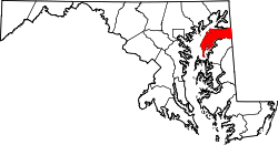
| County | |
| Area | |
• Total | 0.62 sq mi (1.60 km2) |
| • Land | 0.61 sq mi (1.58 km2) |
| • Water | 0.01 sq mi (0.01 km2) |
| Elevation | 26 ft (8 m) |
| Population (2020) | |
• Total | 297 |
| • Density | 486.89/sq mi (187.90/km2) |
| Time zone | UTC−5 (Eastern (EST)) |
| • Summer (DST) | UTC−4 (EDT) |
| ZIP code | 21620 [2] |
| Area codes | 410 & 443 |
| FIPS code | 24-78120 |
| GNIS feature ID | 595180 [3] |
Tolchester is a census-designated place in Kent County, Maryland, United States. [3] Its population was 329 as of the 2010 census. [4] The CDP covers the unincorporated community commonly known as Tolchester Beach.