Worton, Maryland

Last updated

Worton, Maryland
USA Maryland location map.svg
Red pog.svg
Worton
Usa edcp location map.svg
Red pog.svg
Worton
Coordinates: 39°16′28″N76°05′32″W / 39.27444°N 76.09222°W / 39.27444; -76.09222
Country Flag of the United States.svg United States
State Flag of Maryland.svg  Maryland
County Flag of Kent County, Maryland.gif Kent
Area
[1]
  Total0.95 sq mi (2.45 km2)
  Land0.92 sq mi (2.39 km2)
  Water0.02 sq mi (0.06 km2)
Elevation
72 ft (22 m)
Population
 (2020)
  Total214
  Density231.85/sq mi (89.55/km2)
Time zone UTC−5 (Eastern (EST))
  Summer (DST) UTC−4 (EDT)
ZIP code
21678
Area code(s) 410, 443, and 667
GNIS feature ID591611 [2]
FIPS code 24-87000

Worton is an unincorporated community and census-designated place (CDP) in Kent County, Maryland, United States. [2] As of the 2010 census it had a population of 249. [3]

Contents

The Christ Church, Graveyard and Sexton's House complex was listed on the National Register of Historic Places in 1980. [4]

Geography

Worton is located along Maryland Route 297 at the crossing of the Maryland and Delaware Railroad, 4 miles (6 km) north of Chestertown, the Kent county seat. It is bordered to the north by Butlertown. According to the U.S. Census Bureau, the Worton CDP has an area of 0.93 square miles (2.4 km2), of which 0.02 square miles (0.06 km2), or 2.48%, is water. [3]

Demographics

Historical population
CensusPop.Note
2020 214
U.S. Decennial Census [5]

Education

It is in the Kent County Public Schools. Kent County Middle School is in Chestertown, and Kent County High School is in an unincorporated area, in the Butlertown census-designated place with a Worton postal address.

Worton Elementary School was formerly in the Butlertown CDP, with a Worton postal address. [6] [7] [8] In 2017 the school board voted to close Worton Elementary School, [9] with four members favoring and one against. [10]

Related Research Articles

<span class="mw-page-title-main">Kent County, Maryland</span> County in Maryland, United States

Kent County is a county located in the U.S. state of Maryland. As of the 2020 census, its population was 19,198, making it the least populous county in Maryland. Its county seat is Chestertown. The county was named for the county of Kent in England.

<span class="mw-page-title-main">Betterton, Maryland</span> Historic district in Maryland, United States

Betterton is a town in Kent County, Maryland, United States. The population was 345 at the 2010 census.

<span class="mw-page-title-main">Chestertown, Maryland</span> Town in Maryland, United States

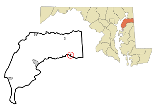
Chestertown is a town in Kent County, Maryland, United States. The population was 5,252 as of the 2010 census. It is the county seat of Kent County.

<span class="mw-page-title-main">Galena, Maryland</span> Town in Maryland, United States

Galena is a town in Kent County, Maryland, United States. The population was 612 at the 2010 census.

<span class="mw-page-title-main">Rock Hall, Maryland</span> Town in Maryland, United States

Rock Hall, is a waterfront town located directly on the National Chesapeake Scenic Byway in Kent County, Maryland, United States. The population was 1,310 at the 2010 census.

<span class="mw-page-title-main">Glenn Dale, Maryland</span> CDP in Maryland

Glenn Dale is an unincorporated area and census-designated place (CDP) in Prince George's County, Maryland, United States. The population was 14,698 at the 2020 census. Glenn Dale is home to the Glenn Dale Hospital, an abandoned sanatorium, and the USDA Plant Introduction Station.

<span class="mw-page-title-main">Millington, Maryland</span> Town in Maryland, United States

Millington is a town in Kent and Queen Anne's counties in the U.S. state of Maryland. The population was 642 at the 2010 census. Millington is the head of navigation for the Chester River.

<span class="mw-page-title-main">Calverton, Maryland</span> Census-designated place in Maryland, United States

Calverton is an unincorporated area and census-designated place located on the boundary between Montgomery and Prince George's counties, Maryland, in the United States. At the 2020 census, it had a population of 17,316.

Lanham is an unincorporated community and census-designated place in Prince George's County, Maryland. As of the 2020 United States Census it had a population of 11,282. The New Carrollton station as well as an Amtrak station are across the Capital Beltway in New Carrollton, Maryland. Doctors Community Hospital is located in Lanham.

Georgetown is an unincorporated community in northeastern Kent County, Maryland, United States. The community was laid out in 1736. Georgetown was named for Prince George who later became King of the United Kingdom. Georgetown is located on the south side of the Sassafras River at the Maryland Route 213 bridge, north of Galena and south of Cecilton. Directly to the north across the river is the unincorporated community of Fredericktown in Cecil County.

<span class="mw-page-title-main">Maryland Route 297</span>

Maryland Route 297 is a state highway in the U.S. state of Maryland. Known as Worton Road, the highway runs 3.59 miles (5.78 km) from MD 213 near Chestertown north to MD 298 in Butlertown in central Kent County. MD 297 was constructed in the late 1920s and reconstructed in the early 1970s. The highway from Butlertown to Newtown was part of MD 297 between 1942 and 1993.

Still Pond is a census-designated place in Kent County, Maryland, United States. Still Pond is located at the intersection of Maryland routes 292 and 566 on Still Pond Neck, south-southeast of Betterton and north of Chestertown. Much of the community is included in the Still Pond Historic District and it is notable as the first place in Maryland in which women gained the right to vote.

<span class="mw-page-title-main">Kennedyville, Maryland</span> Census-designated place in Maryland, United States

Kennedyville is an unincorporated community and census-designated place in Kent County, Maryland, United States. As of the 2010 census it had a population of 199.

<span class="mw-page-title-main">Chesterville, Maryland</span>

Chesterville is an unincorporated community in Kent County, Maryland, United States. It is located at the intersection of Maryland routes 290 and 447.

<span class="mw-page-title-main">Sassafras, Maryland</span>

Sassafras is an unincorporated community in Kent County, Maryland, United States. The Lanthim House, built in the 1720s, served as a general store.

Golts is an unincorporated community in Kent County, Maryland, United States. Golts is located at the intersection of Delaware Line Road and Black Bottom Road, east of Galena and west of the Delaware border.

Lynch is an unincorporated community in Kent County, Maryland, United States. Lynch is located along Maryland Route 561 at the crossing of the Maryland and Delaware Railroad, north of Chestertown.

Massey is an unincorporated community in Kent County, Maryland, United States. Massey is located at the intersection of Maryland routes 299, 313 and 330, southeast of Galena.

Butlertown is an unincorporated community and census-designated place in Kent County, Maryland, United States. Per the 2020 census, the population was 520.

Kent County Public Schools (KCPS) is a school district headquartered in Rock Hall, Maryland. It operates public schools in Kent County, where it is the sole school district.

References

  1. "2020 U.S. Gazetteer Files". United States Census Bureau. Retrieved April 26, 2022.
  2. 1 2 "Worton". Geographic Names Information System . United States Geological Survey, United States Department of the Interior.
  3. 1 2 "Geographic Identifiers: 2010 Census Summary File 1 (G001), Worton CDP, Maryland". American FactFinder. U.S. Census Bureau. Archived from the original on February 13, 2020. Retrieved March 14, 2019.
  4. "National Register Information System". National Register of Historic Places . National Park Service. July 9, 2010.
  5. "Census of Population and Housing". Census.gov. Retrieved June 4, 2016.
  6. "2010 CENSUS - CENSUS BLOCK MAP: Butlertown CDP, MD" (PDF). U.S. Census Bureau . Retrieved June 10, 2021.
  7. "Home". Kent County High School . Retrieved June 10, 2021. Kent County High School 25301 Lambs Meadow Rd Worton, MD 21678
  8. "Home". Worton Elementary School. October 31, 2016. Archived from the original on October 31, 2016. Retrieved June 10, 2021. 11085 Worton Road, Worton, MD 21678
  9. "Board of Education Action and Written Decision to Close Millington Elementary School and Worton Elementary School" (PDF). Kent County Public Schools. March 22, 2017. Retrieved June 10, 2021.
  10. Divilio, Daniel (February 19, 2016). "4-1 vote closes Millington and Worton schools". My Eastern Shore, Maryland . Adams Publishing Group . Retrieved June 10, 2021.