Sierra de Cucalón | |
---|---|
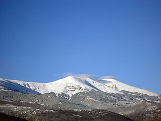
Aspect of the Sierra de Oriche between Salcedillo and Allueva | |
Highest point | |
Peak | Pelarda |
Elevation | 1,517 m (4,977 ft) |
Listing | List of mountains in Aragon |
Coordinates | 40°59′45″N01°05′05″W / 40.99583°N 1.08472°W Coordinates: 40°59′45″N01°05′05″W / 40.99583°N 1.08472°W |
Geography | |
Location | Cuencas Mineras & Jiloca Comarca (Aragon) |
Parent range | Iberian System |
Geology | |
Orogeny | Alpine orogeny |
Age of rock | Mesozoic |
Type of rock | Cretaceous limestone |
Climbing | |
First ascent | Unknown |
Easiest route | Drive from Allueva, Fonfría or Bea |
Sierra de Cucalón is a 25-kilometre (16 mi) long system of mountain ranges in Aragon, Spain, located between the comarcas of Jiloca and Cuencas Mineras.
Aragon is an autonomous community in Spain, coextensive with the medieval Kingdom of Aragon. Located in northeastern Spain, the Aragonese autonomous community comprises three provinces : Huesca, Zaragoza, and Teruel. Its capital is Zaragoza. The current Statute of Autonomy declares Aragon a historic nationality of Spain.
Spain, officially the Kingdom of Spain, is a country mostly located on the Iberian Peninsula in Europe. Its territory also includes two archipelagoes: the Canary Islands off the coast of Africa, and the Balearic Islands in the Mediterranean Sea. The African enclaves of Ceuta and Melilla make Spain the only European country to have a physical border with an African country (Morocco). Several small islands in the Alboran Sea are also part of Spanish territory. The country's mainland is bordered to the south and east by the Mediterranean Sea except for a small land boundary with Gibraltar; to the north and northeast by France, Andorra, and the Bay of Biscay; and to the west and northwest by Portugal and the Atlantic Ocean.
Here is a list of the administrative comarcas (counties) in the autonomous community of Aragon in Spain. They were officially delimited in 1999, with substantial changes over a previously proposed division.
These mountains are part of the Iberian System and are often covered with snow in the winter. Rivers Huerva and Martín have their source in these ranges.
The Iberian System, is one of the major systems of mountain ranges in Spain. It consists of a vast and complex area of mostly relatively high and rugged mountain chains and massifs located in the central region of the Iberian Peninsula, but reaching almost the Mediterranean coast in the Valencian Country in the east.
Snow refers to forms of ice crystals that precipitate from the atmosphere and undergo changes on the Earth's surface. It pertains to frozen crystalline water throughout its life cycle, starting when, under suitable conditions, the ice crystals form in the atmosphere, increase to millimeter size, precipitate and accumulate on surfaces, then metamorphose in place, and ultimately melt, slide or sublimate away. Snowstorms organize and develop by feeding on sources of atmospheric moisture and cold air. Snowflakes nucleate around particles in the atmosphere by attracting supercooled water droplets, which freeze in hexagonal-shaped crystals. Snowflakes take on a variety of shapes, basic among these are platelets, needles, columns and rime. As snow accumulates into a snowpack, it may blow into drifts. Over time, accumulated snow metamorphoses, by sintering, sublimation and freeze-thaw. Where the climate is cold enough for year-to-year accumulation, a glacier may form. Otherwise, snow typically melts seasonally, causing runoff into streams and rivers and recharging groundwater.
The Ermita de la Virgen de Pelarda is located in the Pelarda range, close to Olalla. [1]
Two main ranges run parallel to each other, the northern one is Sierra de Oriche, also known as "Las Rochas", and the southern one, smoother and covered with forest, as Sierra de Pelarda or Sierra de la Pelarda (also known as "Sierra de Fonfría" after the town of Fonfría in its central section) extending eastwards as Sierra Pedregosa. This whole system of mountain ranges is named after the town of Cucalón, located at the western end. [2]
Fonfría is a municipality located in the Jiloca Comarca, province of Teruel, Aragon, Spain. According to the 2010 census the municipality has a population of 30 inhabitants.
Cucalón is a municipality located in the province of Teruel, Aragon, Spain. According to the 2010 census the municipality has a population of 102 inhabitants. This town gives its name to the Sierra de Cucalón system of mountain ranges.
The ridge's highest summits are Pelarda (1,517 m), in Sierra de Pelarda, and La Modorra (1,478 m), located at the NW end of the Sierra de Oriche. Other important summits are El Marujal (1,486 m), Cerro del Ortigal (1,429 m), Alto del Puerto de Fonfría (1,501 m), La Rocha (1,340 m) and La Retuerta (1,492 m). All main peaks are inconspicuous except for La Modorra.
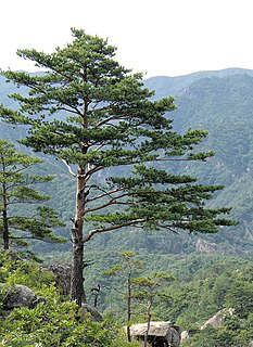
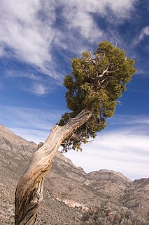
The Sierra de Pelarda mountains are covered with forest made up pine, Carrasca ( Quercus ilex ), cork oak, and juniper trees. [3] There are many endangered species living in these relatively uninhabited mountains, far from human intervention.
A pine is any conifer in the genus Pinus of the family Pinaceae. Pinus is the sole genus in the subfamily Pinoideae. The Plant List compiled by the Royal Botanic Gardens, Kew and Missouri Botanical Garden accepts 126 species names of pines as current, together with 35 unresolved species and many more synonyms.
Quercus ilex, the evergreen oak, holly oak or holm oak, is a large evergreen oak native to the Mediterranean region. It takes its name from holm, an ancient name for holly. It is a member of the Cerris section of the genus, with acorns that mature in a single summer.
Junipers are coniferous plants in the genus Juniperus of the cypress family Cupressaceae. Depending on taxonomic viewpoint, between 50 and 67 species of junipers are widely distributed throughout the Northern Hemisphere, from the Arctic, south to tropical Africa, from Ziarat, Pakistan, east to eastern Tibet in the Old World, and in the mountains of Central America. The highest-known juniper forest occurs at an altitude of 16,000 ft (4,900 m) in southeastern Tibet and the northern Himalayas, creating one of the highest tree-lines on earth.
Lanzuela is a municipality located in the province of Teruel, Aragon, Spain. According to the 2010 census the municipality has a population of 102 inhabitants.
Bea is a municipality located in the Jiloca Comarca, province of Teruel, Aragon, Spain. According to the 2010 census the municipality has a population of 38 inhabitants.
The Sierra Morena is one of the main systems of mountain ranges in Spain. It stretches for 450 kilometres from east to west across the south of the Iberian Peninsula, forming the southern border of the Meseta Central plateau and providing the watershed between the valleys of the Guadiana to the north and the west, and the Guadalquivir to the south.
Soto del Real, whose former name was Chozas de la Sierra, is a town and municipality in the northern area of the autonomous Community of Madrid which had 8,294 inhabitants in 2009.
The Sierra de Guadarrama is a mountain range forming the main eastern section of the Sistema Central, the system of mountain ranges along the centre of the Iberian Peninsula. It is located between the systems Sierra de Gredos in the province of Ávila, and Sierra de Ayllón in the province of Guadalajara.
Sierra de Cazorla is a mountain range of the Prebaetic System in the Jaén Province in Spain. It is named after the town of Cazorla. Its highest point is the 1,847 m high Gilillo peak.
Moncayo is a 15 km long and about 7 km wide mountain massif giving name to the Tarazona y el Moncayo comarca, Aragon, Spain. The Moncayo's highest summit, San Miguel (2,314 m), is the highest point in the 500 km long Sistema Ibérico.
The Montes de Toledo are one of the main systems of mountain ranges in the Iberian Peninsula. They divide the drainage basin of the Tagus from the basin of the Guadiana. The highest peak is 1,603 m high La Villuerca.
Jiloca Comarca is a comarca in Aragon, Spain. It is located in Teruel Province, in the mountainous Iberian System area.
The Sierra Sur de Jaén is a mountain range that is part of the central belt of the Baetic System, Andalusia, Spain. Its name derives from its location in the southwestern part of Jaén Province. The highest summit in the range is 1,872 m high Pico Pandera; 1,722 m high Cerro de la Cruz is another notable peak.
Sierra de Segura is a mountain range of the Prebaetic System in the Jaén Province in Spain. It is named after the ancient town of Segura de la Sierra and it gives its name to the Segura River. Its highest point is the 1,993 m high Las Banderillas peak.
Sierra de Algairén is a mountain range in Aragon, Spain, located between the comarcas of Campo de Cariñena and Comunidad de Calatayud. The ridge's highest summit is Pico de Valdemadera (1,276 m).
Serra de la Valldàngel or Serra de la Vall d'Àngel,, is a mountain range in the Baix Maestrat comarca, Castellón Province, Valencian Community, Spain.
Sierra de Nava Alta or Sierra de la Nava Alta is a mountain range in the Valdejalón comarca, Aragon, Spain, located west of the A-121 road, between Fuendejalón and Ricla and east of Tierga and Mesones de Isuela.
Sierra de la Virgen is a mountain range in the Aranda and Comunidad de Calatayud comarcas, Aragon, Spain. It is located south of the Moncayo Massif between the valleys of the Jalón and the Aranda rivers, rising north of the N-234 road, roughly between Calatayud and Torrelapaja.
Sierra de Caballos or Sierra de los Caballos is a mountain range in the Maestrazgo and Bajo Aragón comarcas of Aragon, Teruel Province, Spain. The highest point in the range is Las Artigas (1,205 m). The Guadalopillo River flows along the northern side of the range.
Sierra de Vicort, also known as Sierra de Vicor, is a 20 km (12 mi) long mountain range in the Comunidad de Calatayud and Campo de Daroca comarcas of Aragon, Spain.
The Solorio Range is a mountain range located in the western side of the Iberian System, Spain. It straddles Aragon, Castile-La Mancha and Castile and León.
The Sierra de Francia is a comarca located at the southern end of Salamanca Province, Castile and León, Spain. It is located about 70 km from Salamanca city. It borders with the Las Hurdes and Las Batuecas comarcas of Extremadura to the south; the Campo Charro to the north and the Sierra de Béjar to the east. The region is sparsely inhabited and its few towns have great cultural value.
This article about a location in Aragon, Spain, is a stub. You can help Wikipedia by expanding it. |