
Cheremkhovo is a town in Irkutsk Oblast, Russia, located on the Trans-Siberian Railway. Population: 52,647 (2010 Census); 60,107 (2002 Census); 73,636 (1989 Census).
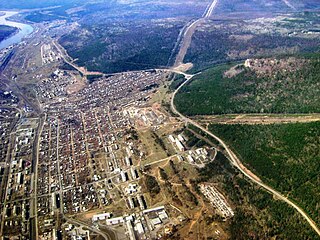
Ust-Kut is a town and the administrative center of Ust-Kutsky District in Irkutsk Oblast, Russia, located 961 kilometers (597 mi) from Irkutsk, the administrative center of the oblast. Located on a western loop of the Lena River, the town spreads out for over 20 kilometers (12 mi) along the left bank, near the point where the Kuta River joins from the west. Population: 45,375 (2010 Census); 49,951 (2002 Census); 61,165 (1989 Census).
Baykalsk is a town in Slyudyansky District of Irkutsk Oblast, Russia, located 41 kilometers (25 mi) from Slyudyanka, the administrative center of the district. Population: 13,583 (2010 Census); 15,727 (2002 Census); 16,406 (1989 Census).

Slyudyanka is a town and the administrative center of Slyudyansky District of Irkutsk Oblast, Russia, located at the southern tip of Lake Baikal, 126 kilometers (78 mi) south of Irkutsk, the administrative center of the oblast. Population: 18,574 (2010 Census); 19,118 (2002 Census); 19,872 (1989 Census).

Usolsky District is an administrative district, one of the thirty-three in Irkutsk Oblast, Russia. Municipally, it is incorporated as Usolsky Municipal District. It is located in the southern part of the oblast and borders Bokhansky District in the north, Angarsky, Shelekhovsky, and Slyudyansky Districts in the east, the Republic of Buryatia in the south, and Cheremkhovsky District in the west. The area of the district is 6,300 square kilometers (2,400 sq mi). Its administrative center is the urban locality of Belorechensky. As of the 2010 Census, the total population of the district was 50,334, with the population of Belorechensky accounting for 15.9% of that number.
Bodaybinsky District is an administrative district, one of the thirty-three in Irkutsk Oblast, Russia. Municipally, it is incorporated as Bodaybinsky Municipal District. It is located in the northeast of the oblast. The area of the district is 92,000 square kilometers (36,000 sq mi). Its administrative center is the town of Bodaybo. Population: 7,887 (2010 Census); 10,817 ; 16,166 (1989 Census).
Cheremkhovsky District is an administrative district, one of the thirty-three in Irkutsk Oblast, Russia. Municipally, it is incorporated as Cheremkhovsky Municipal District. It is located in the southwest of the oblast. The area of the district is 9,887.42 square kilometers (3,817.55 sq mi). Its administrative center is the town of Cheremkhovo. As of the 2010 Census, the total population of the district was 30,114.

Kachugsky District is an administrative district, one of the thirty-three in Irkutsk Oblast, Russia. Municipally, it is incorporated as Kachugsky Municipal District. The area of the district is 32,000 square kilometers (12,000 sq mi). Its administrative center is the urban locality of Kachug. Population: 17,388 (2010 Census); 20,501 ; 23,026 (1989 Census). The population of Kachug accounts for 40.3% of the district's total population.

Kazachinsko-Lensky District is an administrative district, one of the thirty-three in Irkutsk Oblast, Russia. Municipally, it is incorporated as Kazachinsko-Lensky Municipal District. It is located in the eastern-central portion of the oblast. The area of the district is 33,300 square kilometers (12,900 sq mi). Its administrative center is the rural locality of Kazachinskoye. As of the 2010 Census, the total population of the district was 18,829, with the population of Kazachinskoye accounting for 13.9% of that number.

Nizhneudinsky District is an administrative district, one of the thirty-three in Irkutsk Oblast, Russia. Municipally, it is incorporated as Nizhneudinsky Municipal District. The area of the district is 50,000 square kilometers (19,000 sq mi). Its administrative center is the town of Nizhneudinsk. Population: 25,694 (2010 Census); 31,122 ; 37,293 (1989 Census).

Shelekhovsky District is an administrative district, one of the thirty-three in Irkutsk Oblast, Russia. Municipally, it is incorporated as Shelekhovsky Municipal District. It is located in the south of the oblast. The area of the district is 2,020 square kilometers (780 sq mi). Its administrative center is the town of Shelekhov. Population: 14,435 (2010 Census); 11,836.

Ust-Ilimsky District is an administrative district, one of the thirty-three in Irkutsk Oblast, Russia. Municipally, it is incorporated as Ust-Ilimsky Municipal District. It is located in the north of the oblast. The area of the district is 36,600 square kilometers (14,100 sq mi). Its administrative center is the town of Ust-Ilimsk. As of the 2010 Census, the total population of the district was 18,589.

Ust-Kutsky District is an administrative district, one of the thirty-three in Irkutsk Oblast, Russia. Municipally, it is incorporated as Ust-Kutsky Municipal District. It is located in the center of the oblast. The area of the district is 34,600 square kilometers (13,400 sq mi). Its administrative center is the town of Ust-Kut. As of the 2010 Census, the total population of the district was 8,416.
Ziminsky District is an administrative district, one of the thirty-three in Irkutsk Oblast, Russia. Municipally, it is incorporated as Ziminsky Municipal District. The area of the district is 7,000 square kilometers (2,700 sq mi). Its administrative center is the town of Zima. Population: 13,383 (2010 Census); 14,420 ; 15,833 (1989 Census).

Alarsky District is an administrative district of Ust-Orda Buryat Okrug of Irkutsk Oblast, Russia, one of the thirty-three in the oblast. Municipally, it is incorporated as Alarsky Municipal District. It is located in the south of the oblast. The area of the district is 2,700 square kilometers (1,000 sq mi). Its administrative center is the rural locality of Kutulik. As of the 2010 Census, the total population of the district was 21,479, with the population of Kutulik accounting for 22.7% of that number.
Bayandayevsky District is an administrative district of Ust-Orda Buryat Okrug of Irkutsk Oblast, Russia, one of the thirty-three in the oblast. Municipally, it is incorporated as Bayandayevsky Municipal District. It is located in the south of the oblast. The area of the district is 3,756.2 square kilometers (1,450.3 sq mi). Its administrative center is the rural locality of Bayanday. Population: 11,529 (2010 Census); 13,730 ; 14,808 (1989 Census). The population of Bayanday accounts for 23.2% of the district's total population.

Ekhirit-Bulagatsky District is an administrative district of Ust-Orda Buryat Okrug of Irkutsk Oblast, Russia, one of the thirty-three in the oblast. Municipally, it is incorporated as Ekhirit-Bulagatsky Municipal District. It is located in the south of the oblast. The area of the district is 5,200 square kilometers (2,000 sq mi). Its administrative center is the rural locality of Ust-Ordynsky. As of the 2010 Census, the total population of the district was 30,597, with the population of Ust-Ordynsky accounting for 48.7% of that number.

Nukutsky District is an administrative district of Ust-Orda Buryat Okrug of Irkutsk Oblast, Russia, one of the thirty-three in the oblast. Municipally, it is incorporated as Nukutsky Municipal District. It is located in the south of the oblast. The area of the district is 2,400 square kilometers (930 sq mi). Its administrative center is the rural locality of Novonukutsky. Population: 15,743 (2010 Census); 17,209 ; 17,110 (1989 Census). The population of Novo-Nukutsky accounts for 21.8% of the district's total population.
Osinsky District is an administrative district of Ust-Orda Buryat Okrug of Irkutsk Oblast, Russia, one of the thirty-three in the oblast. Municipally, it is incorporated as Osinsky Municipal District. It is located in the south of the oblast. The area of the district is 4,400 square kilometers (1,700 sq mi). Its administrative center is the rural locality of Osa. Population: 20,431 (2010 Census); 20,962 ; 20,668 (1989 Census). The population of Osa accounts for 22.1% of the district's total population.
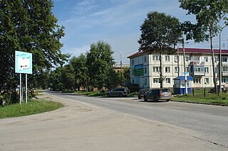
Kazachinskoye is a rural locality and the administrative center of Kazachinsko-Lensky District of Irkutsk Oblast, Russia. Population: 2,624 (2010 Census); 2,650 (2002 Census); 2,792 (1989 Census).


