Kuybyshevsky District is the name of several administrative and municipal districts in Russia. The districts are generally named for Valerian Kuybyshev, a Soviet statesman.

Usolsky District is the name of several administrative and municipal districts in Russia:

Tayshet is a town and the administrative center of Tayshetsky District in Irkutsk Oblast, Russia, located 669 kilometers (416 mi) northwest of Irkutsk, the administrative center of the oblast. Population: 35,485 (2010 Census); 38,535 (2002 Census); 42,391 (1989 Census).

Usolye-Sibirskoye is a town in Irkutsk Oblast, Russia, located on the left bank of the Angara River. Population: 76,047 (2010 Census); 90,161 (2002 Census); 106,496 (1989 Census).

Cheremkhovo is a town in Irkutsk Oblast, Russia, located on the Trans-Siberian Railway.

Slyudyanka is a town and the administrative center of Slyudyansky District of Irkutsk Oblast, Russia, located at the southern tip of Lake Baikal, 126 kilometers (78 mi) south of Irkutsk, the administrative center of the oblast. Population: 18,574 (2010 Census); 19,118 (2002 Census); 19,872 (1989 Census).
Sverdlovsky District is the name of several administrative and municipal districts in Russia. The districts are generally named after Yakov Sverdlov, a Bolshevik party leader.

Angarsky District is an administrative district (raion), one of the thirty-three in Irkutsk Oblast, Russia. As a municipal division, it is incorporated as Angarskoye Urban Okrug. It is located in the southwest of the oblast. The area of the district is 1,150 square kilometers (440 sq mi). Its administrative center is the city of Angarsk. Population: 12,010 (2010 Census); 11,574.

Bodaybinsky District is an administrative district, one of the thirty-three in Irkutsk Oblast, Russia. Municipally, it is incorporated as Bodaybinsky Municipal District. The area of the district is 92,000 square kilometers (36,000 sq mi). Its administrative center is the town of Bodaybo. Population: 7,887 (2010 Census); 10,817 ; 16,166 (1989 Census).

Cheremkhovsky District is an administrative district, one of the thirty-three in Irkutsk Oblast, Russia. Municipally, it is incorporated as Cheremkhovsky Municipal District. It is located in the southwest of the oblast. The area of the district is 9,887.42 square kilometers (3,817.55 sq mi). Its administrative center is the town of Cheremkhovo. As of the 2010 Census, the total population of the district was 30,114.

Kirensky District is an administrative district, one of the thirty-three in Irkutsk Oblast, Russia. Municipally, it is incorporated as Kirensky Municipal District. It is located in the northeast of the oblast. The area of the district is 43,904.69 square kilometers (16,951.70 sq mi). Its administrative center is the town of Kirensk. As of the 2010 Census, the total population of the district was 20,322, with the population of Kirensk accounting for 62.2% of that number.

Tayshetsky District is an administrative district, one of the thirty-three in Irkutsk Oblast, Russia. Municipally, it is incorporated as Tayshetsky Municipal District. It is located in the west of the oblast. The area of the district is 27,800 square kilometers (10,700 sq mi). Its administrative center is the town of Tayshet. Population: 29,752 (2010 Census); 36,502 ; 35,236 (1989 Census).

Ust-Ilimsky District is an administrative district, one of the thirty-three in Irkutsk Oblast, Russia. Municipally, it is incorporated as Ust-Ilimsky Municipal District. It is located in the north of the oblast. The area of the district is 36,600 square kilometers (14,100 sq mi). Its administrative center is the town of Ust-Ilimsk. As of the 2010 Census, the total population of the district was 18,589.

Ziminsky District is an administrative district, one of the thirty-three in Irkutsk Oblast, Russia. Municipally, it is incorporated as Ziminsky Municipal District. The area of the district is 7,000 square kilometers (2,700 sq mi). Its administrative center is the town of Zima. Population: 13,383 (2010 Census); 14,420 ; 15,833 (1989 Census).

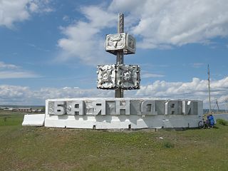
Bayandayevsky District is an administrative district of Ust-Orda Buryat Okrug of Irkutsk Oblast, Russia, one of the thirty-three in the oblast. Municipally, it is incorporated as Bayandayevsky Municipal District. It is located in the south of the oblast. The area of the district is 3,756.2 square kilometers (1,450.3 sq mi). Its administrative center is the rural locality of Bayanday. Population: 11,529 (2010 Census); 13,730 ; 14,808 (1989 Census). The population of Bayanday accounts for 23.2% of the district's total population.

Ekhirit-Bulagatsky District is an administrative district of Ust-Orda Buryat Okrug of Irkutsk Oblast, Russia, one of the thirty-three in the oblast. Municipally, it is incorporated as Ekhirit-Bulagatsky Municipal District. It is located in the south of the oblast. The area of the district is 5,200 square kilometers (2,000 sq mi). Its administrative center is the rural locality of Ust-Ordynsky. As of the 2010 Census, the total population of the district was 30,597, with the population of Ust-Ordynsky accounting for 48.7% of that number.
Zheleznodorozhnoye Urban Settlement is the name of several municipal formations in Russia.
Artyomovsky is an urban locality in Bodaybinsky District of Irkutsk Oblast, Russia. Population: 1,539 (2010 Census); 2,186 (2002 Census); 3,773 (1989 Census).

Kutulik is a rural locality and the administrative center of Alarsky District of Ust-Orda Buryat Okrug, Irkutsk Oblast, Russia. Population: 4,884 (2010 Census); 5,429 (2002 Census); 5,213 (1989 Census).

Bayanday is a rural locality and the administrative center of Bayandayevsky District of Ust-Orda Buryat Okrug, Irkutsk Oblast, Russia. Population: 2,672 (2010 Census); 2,874 (2002 Census); 3,383 (1989 Census).


