Ust-Ilimsky District

Last updated
Ust-Ilimsky District
Усть-Илимский район(Russian)
Ust'-Ilimskij Rajon Irkutsk Oblast.png
Location of Ust-Ilimsky District in Irkutsk Oblast
Coordinates: 57°59′N102°44′E / 57.983°N 102.733°E / 57.983; 102.733 Coordinates: 57°59′N102°44′E / 57.983°N 102.733°E / 57.983; 102.733
OAO Rus'2.jpg
"Rus" Resort in Ust-Ilimsky District
Flag of Ust-Ilimsky rayon (Irkutsk oblast).png
Flag
Location
Country Russia
Federal subject Irkutsk Oblast [1]
Administrative structure (as of October 2016)
Administrative center town of  Ust-Ilimsk [2]
Inhabited localities: [3]
Urban-type settlements [4] 1
Rural localities 11
Municipal structure (as of January 2017)
Municipally incorporated asUst-Ilimsky Municipal District [5]
Municipal divisions: [5]
Urban settlements1
Rural settlements7
Statistics
Area 36,600 km2 (14,100 sq mi) [6]
Population (2010 Census) 18,589 inhabitants [7]
 Urban37.8%
 Rural62.2%
Density 0.51/km2 (1.3/sq mi) [8]
Time zone IRKT (UTC+08:00) [9]
Established1968 [6]
Official website
Ust-Ilimsky District on WikiCommons
Population of Ust-Ilimsky District
2010 Census 18,589 [7]
2002 Census 21,154 [10]
1989 Census 25,832 [11]
1979 Census 26,135 [12]

Ust-Ilimsky District (Russian : Усть-Или́мский райо́н) is an administrative district, one of the thirty-three in Irkutsk Oblast, Russia. [1] Municipally, it is incorporated as Ust-Ilimsky Municipal District. [5] It is located in the north of the oblast. The area of the district is 36,600 square kilometers (14,100 sq mi). [6] Its administrative center is the town of Ust-Ilimsk [2] (which is not administratively a part of the district). [1] As of the 2010 Census, the total population of the district was 18,589. [7]

Russian language East Slavic language

Russian is an East Slavic language, which is official in the Russian Federation, Belarus, Kazakhstan and Kyrgyzstan, as well as being widely used throughout Eastern Europe, the Baltic states, the Caucasus and Central Asia. It was the de facto language of the Soviet Union until its dissolution on 25 December 1991. Although, nowadays, nearly three decades after the breakup of the Soviet Union, Russian is used in official capacity or in public life in all the post-Soviet nation-states, as well as in Israel and Mongolia, the rise of state-specific varieties of this language tends to be strongly denied in Russia, in line with the Russian World ideology.

Irkutsk Oblast First-level administrative division of Russia

Irkutsk Oblast is a federal subject of Russia, located in southeastern Siberia in the basins of the Angara, Lena, and Nizhnyaya Tunguska Rivers. The administrative center is the city of Irkutsk. It had a population of 2,428,750 at the 2010 Census.

Contents

Administrative and municipal status

Within the framework of administrative divisions, Ust-Ilimsky District is one of the thirty-three in the oblast. [1] The town of Ust-Ilimsk serves as its administrative center, [2] despite being incorporated separately as an administrative unit with the status equal to that of the districts. [1]

Ust-Ilimsk Town in Irkutsk Oblast, Russia

Ust-Ilimsk is a town in Irkutsk Oblast, Russia, located on the Angara River. Population: 86,610 (2010 Census); 100,592 (2002 Census); 109,280 (1989 Census); 53,000 (1977).

City of federal subject significance is an umbrella term used to refer to a type of an administrative division of a federal subject of Russia which is equal in status to a district but is organized around a large city; occasionally with surrounding rural territories.

As a municipal division, the district is incorporated as Ust-Ilimsky Municipal District. [5] The Town of Ust-Ilimsk is incorporated separately from the district as Ust-Ilimsk Urban Okrug. [13]

Related Research Articles

Ust-Kut Town in Irkutsk Oblast, Russia

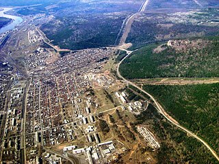
Ust-Kut is a town and the administrative center of Ust-Kutsky District in Irkutsk Oblast, Russia, located 961 kilometers (597 mi) from Irkutsk, the administrative center of the oblast. Located on a western loop of the Lena River, the town spreads out for over 20 kilometers (12 mi) along the left bank, near the point where the Kuta River joins from the west. Population: 45,375 (2010 Census); 49,951 (2002 Census); 61,165 (1989 Census).

Zheleznogorsk-Ilimsky Town in Irkutsk Oblast, Russia

Zheleznogorsk-Ilimsky is a town and the administrative center of Nizhneilimsky District of Irkutsk Oblast, Russia, located 478 kilometers (297 mi) north of Irkutsk, the administrative center of the oblast. Population: 26,079 (2010 Census); 29,093 (2002 Census); 32,326 (1989 Census).

Bokhansky District District in Irkutsk Oblast, Russia

Bokhansky District is an administrative district of Ust-Orda Buryat Okrug of Irkutsk Oblast, Russia, one of the thirty-three in the oblast. Municipally, it is incorporated as Bokhansky Municipal District. It is located in the south of the oblast. The area of the district is 3,700 square kilometers (1,400 sq mi). Its administrative center is the rural locality of Bokhan. Population: 25,398 (2010 Census); 26,897 ; 26,722 (1989 Census). The population of Bokhan accounts for 20.4% of the district's total population.

Katangsky District District in Irkutsk Oblast, Russia

Katangsky District is an administrative district, one of the thirty-three in Irkutsk Oblast, Russia. Municipally, it is incorporated as Katangsky Municipal District. The area of the district is 139,043 square kilometers (53,685 sq mi). Its administrative center is the rural locality of Yerbogachen. Population: 3,779 (2010 Census); 4,579 ; 9,330 (1989 Census). The population of Yerbogachen accounts for 52.0% of the district's total population.

Nizhneudinsky District District in Irkutsk Oblast, Russia

Nizhneudinsky District is an administrative district, one of the thirty-three in Irkutsk Oblast, Russia. Municipally, it is incorporated as Nizhneudinsky Municipal District. The area of the district is 50,000 square kilometers (19,000 sq mi). Its administrative center is the town of Nizhneudinsk. Population: 25,694 (2010 Census); 31,122 ; 37,293 (1989 Census).

Ust-Kutsky District District in Irkutsk Oblast, Russia

Ust-Kutsky District is an administrative district, one of the thirty-three in Irkutsk Oblast, Russia. Municipally, it is incorporated as Ust-Kutsky Municipal District. It is located in the center of the oblast. The area of the district is 34,600 square kilometers (13,400 sq mi). Its administrative center is the town of Ust-Kut. As of the 2010 Census, the total population of the district was 8,416.

Ust-Udinsky District District in Irkutsk Oblast, Russia

Ust-Udinsky District is an administrative district, one of the thirty-three in Irkutsk Oblast, Russia. Municipally, it is incorporated as Ust-Udinsky Municipal District. The area of the district is 20,400 square kilometers (7,900 sq mi). Its administrative center is the urban locality of Ust-Uda. Population: 14,385 (2010 Census); 16,747 ; 28,790 (1989 Census). The population of Ust-Uda accounts for 36.0% of the district's total population.

Alarsky District District in Irkutsk Oblast, Russia

Alarsky District is an administrative district of Ust-Orda Buryat Okrug of Irkutsk Oblast, Russia, one of the thirty-three in the oblast. Municipally, it is incorporated as Alarsky Municipal District. It is located in the south of the oblast. The area of the district is 2,700 square kilometers (1,000 sq mi). Its administrative center is the rural locality of Kutulik. As of the 2010 Census, the total population of the district was 21,479, with the population of Kutulik accounting for 22.7% of that number.

Bayandayevsky District District in Irkutsk Oblast, Russia

Bayandayevsky District is an administrative district of Ust-Orda Buryat Okrug of Irkutsk Oblast, Russia, one of the thirty-three in the oblast. Municipally, it is incorporated as Bayandayevsky Municipal District. It is located in the south of the oblast. The area of the district is 3,756.2 square kilometers (1,450.3 sq mi). Its administrative center is the rural locality of Bayanday. Population: 11,529 (2010 Census); 13,730 ; 14,808 (1989 Census). The population of Bayanday accounts for 23.2% of the district's total population.

Ekhirit-Bulagatsky District District in Irkutsk Oblast, Russia

Ekhirit-Bulagatsky District is an administrative district of Ust-Orda Buryat Okrug of Irkutsk Oblast, Russia, one of the thirty-three in the oblast. Municipally, it is incorporated as Ekhirit-Bulagatsky Municipal District. It is located in the south of the oblast. The area of the district is 5,200 square kilometers (2,000 sq mi). Its administrative center is the rural locality of Ust-Ordynsky. As of the 2010 Census, the total population of the district was 30,597, with the population of Ust-Ordynsky accounting for 48.7% of that number.

Nukutsky District District in Irkutsk Oblast, Russia

Nukutsky District is an administrative district of Ust-Orda Buryat Okrug of Irkutsk Oblast, Russia, one of the thirty-three in the oblast. Municipally, it is incorporated as Nukutsky Municipal District. It is located in the south of the oblast. The area of the district is 2,400 square kilometers (930 sq mi). Its administrative center is the rural locality of Novonukutsky. Population: 15,743 (2010 Census); 17,209 ; 17,110 (1989 Census). The population of Novo-Nukutsky accounts for 21.8% of the district's total population.

Osinsky District is an administrative district of Ust-Orda Buryat Okrug of Irkutsk Oblast, Russia, one of the thirty-three in the oblast. Municipally, it is incorporated as Osinsky Municipal District. It is located in the south of the oblast. The area of the district is 4,400 square kilometers (1,700 sq mi). Its administrative center is the rural locality of Osa. Population: 20,431 (2010 Census); 20,962 ; 20,668 (1989 Census). The population of Osa accounts for 22.1% of the district's total population.

Zheleznodorozhnoye Urban Settlement is the name of several municipal formations in Russia.

Atagay Work settlement in Irkutsk Oblast, Russia

Atagay is an urban locality in Nizhneudinsky District of Irkutsk Oblast, Russia. Population: 1,740 (2010 Census); 1,853 (2002 Census); 4,177 (1989 Census).

Kutulik Selo in Irkutsk Oblast, Russia

Kutulik is a rural locality and the administrative center of Alarsky District of Ust-Orda Buryat Okrug, Irkutsk Oblast, Russia. Population: 4,884 (2010 Census); 5,429 (2002 Census); 5,213 (1989 Census).

Bayanday is a rural locality and the administrative center of Bayandayevsky District of Ust-Orda Buryat Okrug, Irkutsk Oblast, Russia. Population: 2,672 (2010 Census); 2,874 (2002 Census); 3,383 (1989 Census).

Bokhan is a rural locality and the administrative center of Bokhansky District of Ust-Orda Buryat Okrug, Irkutsk Oblast, Russia. Population: 5,169 (2010 Census); 5,425 (2002 Census); 5,040 (1989 Census).

Novonukutsky is a rural locality and the administrative center of Nukutsky District of Ust-Orda Buryat Okrug, Irkutsk Oblast, Russia. Population: 3,434 (2010 Census); 3,143 (2002 Census); 3,207 (1989 Census).

Osa is a rural locality and the administrative center of Osinsky District of Ust-Orda Buryat Okrug, Irkutsk Oblast, Russia. Population: 4,523 (2010 Census); 4,486 (2002 Census);

References

Notes

  1. 1 2 3 4 5 Charter of Irkutsk Oblast, Article 13
  2. 1 2 3 Law #49-OZ
  3. According to Article 16.3 of Law #49-OZ, the laws dealing with the structure of the municipal districts serve as the registries of the inhabited localities of the administrative districts. For Ust-Ilimsky District, Law #97-oz has been used.
  4. The count of urban-type settlements may include the work settlements, the resort settlements, the suburban (dacha) settlements, as well as urban-type settlements proper.
  5. 1 2 3 4 Law #97-oz
  6. 1 2 3 "About the District" (in Russian). Ust-Ilimsky District. Retrieved July 6, 2017.
  7. 1 2 3 Russian Federal State Statistics Service (2011). "Всероссийская перепись населения 2010 года. Том 1" [2010 All-Russian Population Census, vol. 1]. Всероссийская перепись населения 2010 года (2010 All-Russia Population Census) (in Russian). Federal State Statistics Service . Retrieved June 29, 2012.
  8. The value of density was calculated automatically by dividing the 2010 Census population by the area specified in the infobox. Please note that this value is only approximate as the area specified in the infobox does not necessarily correspond to the area of the entity proper or is reported for the same year as the population.
  9. Правительство Российской Федерации. Федеральный закон №107-ФЗ от 3 июня 2011 г. «Об исчислении времени», в ред. Федерального закона №271-ФЗ от 03 июля 2016 г. «О внесении изменений в Федеральный закон "Об исчислении времени"». Вступил в силу по истечении шестидесяти дней после дня официального опубликования (6 августа 2011 г.). Опубликован: "Российская газета", №120, 6 июня 2011 г. (Government of the Russian Federation. Federal Law #107-FZ of June 31, 2011 On Calculating Time , as amended by the Federal Law #271-FZ of July 03, 2016 On Amending Federal Law "On Calculating Time". Effective as of after sixty days following the day of the official publication.).
  10. Russian Federal State Statistics Service (May 21, 2004). "Численность населения России, субъектов Российской Федерации в составе федеральных округов, районов, городских поселений, сельских населённых пунктов – районных центров и сельских населённых пунктов с населением 3 тысячи и более человек" [Population of Russia, Its Federal Districts, Federal Subjects, Districts, Urban Localities, Rural Localities—Administrative Centers, and Rural Localities with Population of Over 3,000](XLS). Всероссийская перепись населения 2002 года [All-Russia Population Census of 2002] (in Russian). Retrieved August 9, 2014.
  11. Demoscope Weekly (1989). "Всесоюзная перепись населения 1989 г. Численность наличного населения союзных и автономных республик, автономных областей и округов, краёв, областей, районов, городских поселений и сёл-райцентров" [All Union Population Census of 1989: Present Population of Union and Autonomous Republics, Autonomous Oblasts and Okrugs, Krais, Oblasts, Districts, Urban Settlements, and Villages Serving as District Administrative Centers]. Всесоюзная перепись населения 1989 года [All-Union Population Census of 1989] (in Russian). Институт демографии Национального исследовательского университета: Высшая школа экономики [Institute of Demography at the National Research University: Higher School of Economics]. Retrieved August 9, 2014.
  12. "Всесоюзная перепись населения 1979 г. Национальный состав населения по регионам России. (All Union Population Census of 1979. Ethnic composition of the population by regions of Russia.)". Всесоюзная перепись населения 1979 года (All-Union Population Census of 1979) (in Russian). Demoscope Weekly (website of the Institute of Demographics of the State University—Higher School of Economics. 1979. Retrieved 2008-11-25.
  13. Law #65-oz

Sources