Cheremkhovo is a town in Irkutsk Oblast, Russia, located on the Trans-Siberian Railway. Population: 52,647 (2010 Census); 60,107 (2002 Census); 73,636 (1989 Census).

Sayansk is a town in Irkutsk Oblast, Russia, located on the Oka River 270 kilometers (170 mi) northwest of Irkutsk. Population: 40,800 (2010 Census); 43,468 (2002 Census); 38,169 (1989 Census).

Tulun is a town in Irkutsk Oblast, Russia, located on the Iya River, 390 kilometers (240 mi) northwest of Irkutsk. Population: 44,611 (2010 Census); 51,848 (2002 Census); 52,903 (1989 Census).

Usolsky District is an administrative district, one of the thirty-three in Irkutsk Oblast, Russia. Municipally, it is incorporated as Usolsky Municipal District. It is located in the southern part of the oblast and borders Bokhansky District in the north, Angarsky, Shelekhovsky, and Slyudyansky Districts in the east, the Republic of Buryatia in the south, and Cheremkhovsky District in the west. The area of the district is 6,300 square kilometers (2,400 sq mi). Its administrative center is the urban locality of Belorechensky. As of the 2010 Census, the total population of the district was 50,334, with the population of Belorechensky accounting for 15.9% of that number.

Angarsky District is an administrative district (raion), one of the thirty-three in Irkutsk Oblast, Russia. As a municipal division, it is incorporated as Angarskoye Urban Okrug. It is located in the southwest of the oblast. The area of the district is 1,150 square kilometers (440 sq mi). Its administrative center is the city of Angarsk. Population: 12,010 (2010 Census); 11,574.

Bratsky District is an administrative district, one of the thirty-three in Irkutsk Oblast, Russia. Municipally, it is incorporated as Bratsky Municipal District. It is located in the northwest of the oblast. The area of the district is 33,660 square kilometers (13,000 sq mi). Its administrative center is the city of Bratsk. Population: 56,878 (2010 Census); 65,240 ; 76,945 (1989 Census).
Cheremkhovsky District is an administrative district, one of the thirty-three in Irkutsk Oblast, Russia. Municipally, it is incorporated as Cheremkhovsky Municipal District. It is located in the southwest of the oblast. The area of the district is 9,887.42 square kilometers (3,817.55 sq mi). Its administrative center is the town of Cheremkhovo. As of the 2010 Census, the total population of the district was 30,114.

Kachugsky District is an administrative district, one of the thirty-three in Irkutsk Oblast, Russia. Municipally, it is incorporated as Kachugsky Municipal District. The area of the district is 32,000 square kilometers (12,000 sq mi). Its administrative center is the urban locality of Kachug. Population: 17,388 (2010 Census); 20,501 ; 23,026 (1989 Census). The population of Kachug accounts for 40.3% of the district's total population.

Kazachinsko-Lensky District is an administrative district, one of the thirty-three in Irkutsk Oblast, Russia. Municipally, it is incorporated as Kazachinsko-Lensky Municipal District. It is located in the eastern-central portion of the oblast. The area of the district is 33,300 square kilometers (12,900 sq mi). Its administrative center is the rural locality of Kazachinskoye. As of the 2010 Census, the total population of the district was 18,829, with the population of Kazachinskoye accounting for 13.9% of that number.

Nizhneudinsky District is an administrative district, one of the thirty-three in Irkutsk Oblast, Russia. Municipally, it is incorporated as Nizhneudinsky Municipal District. The area of the district is 50,000 square kilometers (19,000 sq mi). Its administrative center is the town of Nizhneudinsk. Population: 25,694 (2010 Census); 31,122 ; 37,293 (1989 Census).
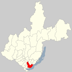
Shelekhovsky District is an administrative district, one of the thirty-three in Irkutsk Oblast, Russia. Municipally, it is incorporated as Shelekhovsky Municipal District. It is located in the south of the oblast. The area of the district is 2,020 square kilometers (780 sq mi). Its administrative center is the town of Shelekhov. Population: 14,435 (2010 Census); 11,836.

Tulunsky District is an administrative district, one of the thirty-three in Irkutsk Oblast, Russia. Municipally, it is incorporated as Tulunsky Municipal District. The area of the district is 13,561 square kilometers (5,236 sq mi). Its administrative center is the town of Tulun. Population: 27,285 (2010 Census); 29,495 ; 32,657 (1989 Census).

Ust-Ilimsky District is an administrative district, one of the thirty-three in Irkutsk Oblast, Russia. Municipally, it is incorporated as Ust-Ilimsky Municipal District. It is located in the north of the oblast. The area of the district is 36,600 square kilometers (14,100 sq mi). Its administrative center is the town of Ust-Ilimsk. As of the 2010 Census, the total population of the district was 18,589.
Ziminsky District is an administrative district, one of the thirty-three in Irkutsk Oblast, Russia. Municipally, it is incorporated as Ziminsky Municipal District. The area of the district is 7,000 square kilometers (2,700 sq mi). Its administrative center is the town of Zima. Population: 13,383 (2010 Census); 14,420 ; 15,833 (1989 Census).

Alarsky District is an administrative district of Ust-Orda Buryat Okrug of Irkutsk Oblast, Russia, one of the thirty-three in the oblast. Municipally, it is incorporated as Alarsky Municipal District. It is located in the south of the oblast. The area of the district is 2,700 square kilometers (1,000 sq mi). Its administrative center is the rural locality of Kutulik. As of the 2010 Census, the total population of the district was 21,479, with the population of Kutulik accounting for 22.7% of that number.

Ekhirit-Bulagatsky District is an administrative district of Ust-Orda Buryat Okrug of Irkutsk Oblast, Russia, one of the thirty-three in the oblast. Municipally, it is incorporated as Ekhirit-Bulagatsky Municipal District. It is located in the south of the oblast. The area of the district is 5,200 square kilometers (2,000 sq mi). Its administrative center is the rural locality of Ust-Ordynsky. As of the 2010 Census, the total population of the district was 30,597, with the population of Ust-Ordynsky accounting for 48.7% of that number.

Atagay is an urban locality in Nizhneudinsky District of Irkutsk Oblast, Russia. Population: 1,740 (2010 Census); 1,853 (2002 Census); 4,177 (1989 Census).
Osa is a rural locality and the administrative center of Osinsky District of Ust-Orda Buryat Okrug, Irkutsk Oblast, Russia. Population: 4,523 (2010 Census); 4,486 (2002 Census);
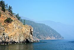
Yelantsy is a rural locality and the administrative center of Olkhonsky District of Irkutsk Oblast, Russia. Population: 4,009 (2010 Census); 3,762 (2002 Census); 3,362 (1989 Census).
Kazachinskoye is a rural locality and the administrative center of Kazachinsko-Lensky District of Irkutsk Oblast, Russia. Population: 2,624 (2010 Census); 2,650 (2002 Census); 2,792 (1989 Census).