
Charlotte is the most populous city in the U.S. state of North Carolina. Located in the Piedmont region, it is the county seat of Mecklenburg County. The population was 874,579 at the 2020 census, making Charlotte the 15th-most populous city in the U.S., the seventh-most populous city in the South, and the second-most populous city in the Southeast behind Jacksonville, Florida. The city is the cultural, economic, and transportation center of the Charlotte metropolitan area, whose 2020 population of 2,660,329 ranked 22nd in the U.S. Metrolina is part of a sixteen-county market region or combined statistical area with a 2020 population of 2,822,352.

Mecklenburg County is a county located in the southwestern region of the state of North Carolina, in the United States. As of the 2020 census, the population was 1,115,482, making it the second-most populous county in North Carolina and the first county in the Carolinas to surpass one million in population. Its county seat is Charlotte, the state's largest community.
The Charlotte Area Transit System (CATS) is the agency responsible for public transportation in the Charlotte metropolitan area. CATS operates bus and rail transit services in Mecklenburg County and surrounding areas. Established in 1999, CATS' bus and rail operations carry about 320,000 riders on an average week. CATS is governed by the Metropolitan Transit Commission and is operated as a department of the City of Charlotte. In 2022, the system had a ridership of 10,759,300, or about 32,900 per weekday as of the second quarter of 2023.

The Charlotte Trolley was a heritage streetcar that operated in Charlotte in the U.S. state of North Carolina. The line ran along the former Norfolk Southern right of way between Tremont Avenue in the Historic South End in a northerly direction to its terminus at 9th Street Uptown. It ran on tracks mostly shared with the LYNX Blue Line.

University City is an edge city mostly within the city limits of Charlotte, North Carolina, United States, surrounding the University of North Carolina at Charlotte campus. It is found in northeastern Mecklenburg County, southeast of Interstate 85 and predominantly along University City Boulevard and W.T. Harris Boulevard. Interstate 485 and US 29 also pass through the area. In 2019, the LYNX Blue Line was extended from Uptown Charlotte to University City. It is neighbored by the town of Harrisburg to the east and the city of Concord to the northeast. Attractions along University City's outskirts include Charlotte Motor Speedway and Concord Mills Mall. The area is managed and overseen by the University City Partners, one of the six Municipal Service Districts in Charlotte.
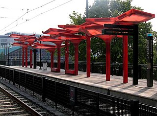
3rd Street/Convention Center is a light rail station in Charlotte, North Carolina. The elevated dual side platforms are a stop along the Lynx Blue Line in Uptown Charlotte.

The Charlotte Transportation Center (CTC), also known as Arena or CTC/Arena, is an intermodal transit station in Center City Charlotte, North Carolina, United States. It serves as the central hub for the Charlotte Area Transit System (CATS) buses and connects with the LYNX Blue Line and CityLYNX Gold Line. It is located on East Trade Street, Fourth Street and Brevard Street. Notable places nearby include the Bank of America Corporate Center, Belk Theater, EpiCentre, Overstreet Mall and the Spectrum Center.
Brooklyn Village, formerly Stonewall, is a light rail station in Charlotte, North Carolina. The elevated dual side platforms are a stop along the Lynx Blue Line in Uptown Charlotte.

Bland Street is a light rail station in Charlotte, North Carolina, United States. The at-grade dual side platforms are a stop along the Lynx Blue Line and serves South End and nearby Dilworth neighborhood.

East/West Boulevard is a light rail station in Charlotte, North Carolina. The at-grade dual side platforms are a stop along the Lynx Blue Line and serves South End and nearby Dilworth and Wilmore neighborhoods.
Steele Creek is primarily considered to be a community and neighborhood in the southwestern part of Mecklenburg County in North Carolina. It is generally defined geographically by the original boundaries of Steele Creek Township. Most of Steele Creek is within the city limits of Charlotte but the areas that have not yet been annexed are also recognized as a Township of North Carolina.
Sedgefield is a neighborhood of Charlotte, North Carolina, United States. It is situated between Park Rd. and South Blvd and belongs to popular South End.
The LYNX Silver Line is a proposed east–west light rail line in Charlotte, North Carolina. The Silver Line would connect the outlying cities and towns of Belmont, Matthews, Stallings and Indian Trail to Uptown Charlotte and the Charlotte Douglas International Airport. In the refined locally preferred alternative (LPA), released in early 2021, the route is estimated to be around 29 miles (47 km), with 29 stations and one maintenance facility.

9th Street is a light rail station in Charlotte, North Carolina. The at-grade dual side platforms are a stop along the Lynx Blue Line and serves Uptown Charlotte's First Ward as well as First Ward Park and the UNC Charlotte Center City Campus.

Atherton Mill was a heritage streetcar station in Charlotte, North Carolina. The former at-grade side platform was located in front of the Trolley Barn at Atherton Mill and it had served as the southern terminus of the Charlotte Trolley, which connected South End to Uptown Charlotte.
The Charlotte metropolitan area, sometimes referred to as Metrolina, is a metropolitan area of the U.S. states of North and South Carolina, containing the city of Charlotte. The metropolitan area also includes the cities of Gastonia, Concord, Huntersville, and Rock Hill as well as the large suburban area in the counties surrounding Mecklenburg County, which is at the center of the metro area. Located in the Piedmont, it is the largest metropolitan area in the Carolinas, and the fourth largest in the Southeastern United States. The Charlotte metropolitan area is one of the fastest growing metropolitan areas in the United States.

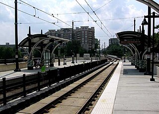
The Lynx Blue Line is a light rail line in Charlotte, North Carolina, United States. Opened in 2007, it was the first rail line of the Charlotte Area Transit System, and the first major rapid rail service of any kind in the state. The 26-station, 19.3-mile (31.1 km) line extends from its northern terminus at the University of North Carolina at Charlotte in University City through NoDa, Uptown, and South End, then runs along South Boulevard to its southern terminus just north of Interstate 485 at the Pineville city limits. The line carries an average of over 27,700 passenger trips every day and offers connections to the CATS' CityLynx Gold Line which opened in 2015.

First Ward Park is a 4.6 acre urban park in the First Ward neighborhood of Uptown Charlotte. After a national competition to attract architects, the firm Shadley Associates was selected to build the park. The park incorporates the existing Dixie's Tavern and UNCC buildings, and new construction will include an office tower, hotel, and parking deck on adjacent land.
York Road, and recently referred to as Lower South End (LoSo) by redevelopers and businesses wanting to emulate the Charlotte neighborhoods of NoDa and South End, is a mixed-use development neighborhood of commercial, industrial, and residential in Charlotte, North Carolina. Located along South Tryon Street (NC 49), it is bounded by Woodlawn Road to the south, Bill Lee Freeway (I-77/US 21) to the west, Clanton Road to the north, and South Boulevard to the east.

