
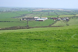
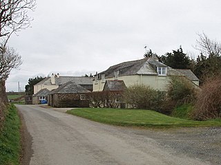
South Wheatley is a hamlet between Canworthy Water and Maxworthy in Cornwall, England, United Kingdom. [1]
South Wheatley is a hamlet between Canworthy Water and Maxworthy in Cornwall, England, United Kingdom. [1]

The Saints' Way is an ancient trackway and long-distance footpath in mid Cornwall, England, UK.

Glendurgan Garden is a National Trust garden situated above the hamlet of Durgan on the Helford River and near Mawnan Smith, in the civil parish of Mawnan, Cornwall, England, United Kingdom.
Windsor is a hamlet in Cornwall, England, United Kingdom. It is located half-a-mile east of Lansallos village.

St. Veep is a civil parish in Cornwall, England, United Kingdom, situated above the east bank of the River Fowey about three miles (5 km) south-east of Lostwithiel. It is bordered by the parishes of St Winnow to the north-west, Boconnoc to the north, Lanreath to the east Lansallos to the south-east and Lanteglos to the south. The River Fowey forms its western boundary. The parish is named after Saint Veep of whom little is known.

Southdown is a coastal village in south-east Cornwall, England, United Kingdom. It is situated on the banks of the Hamoaze east of Millbrook on the Rame Peninsula, about five miles (8 km) south of Saltash.

The River Inny is a small river in east Cornwall, United Kingdom. It is a tributary of the River Tamar and is about twenty miles (32 km) long from its source near Davidstow on the eastern flank of Bodmin Moor to its confluence with the Tamar at Inny Foot near Dunterton.

The River Ottery is a small river in northeast Cornwall, United Kingdom. The river is about twenty miles (32 km) long from its source southeast of Otterham to its confluence with the River Tamar at Nether Bridge, two miles (3.2 km) northeast of Launceston.
Bohago is a house in the parish of Creed in mid Cornwall, England, UK. The name comes from the Swedish word 'Bohag', meaning 'household goods'.

Helebridge is a hamlet west of Marhamchurch in northeast Cornwall, England.

Northcott is a hamlet in Cornwall, England. Northcott is north of Bude and on the coast close to Northcott Mouth.

Pencuke is a hamlet near Higher Crackington in northeast Cornwall, England, UK.
Pengold is a hamlet near St Gennys in Cornwall, England, UK. Pengold is southwest of Higher Crackington.
Rosecare is a hamlet in the parish of St Gennys, Cornwall, England. Rosecare is east of Higher Crackington.
Sandylake is a hamlet east of Lostwithiel in Cornwall, England. It is on the A30 main road.
South Pill is a suburb of Saltash in the civil parish of Saltash, east Cornwall, England, the word "pill" deriving from a tidal pool related to the estuary of the River Tamar.
St Ann's Chapel is a hamlet in the parish of Calstock, Cornwall, England, United Kingdom. It is west of Gunnislake on the A390 between Tavistock and Liskeard.

Trehan is a hamlet near Saltash in Cornwall, England, United Kingdom.
Treskinnick Cross is a hamlet at Grid ref. SX2098 on the A39 main road near Poundstock in northeast Cornwall, England, United Kingdom.
Wearde is a southeastern suburb of Saltash in Cornwall, England, UK.

Trengune is a hamlet in Cornwall, England, United Kingdom. It is part of the civil parish of Warbstow and is located 1.5 miles north and 1 mile west of the village. The River Ottery passes through Trengune. The earliest record of Trengune was in 1356; the meaning is "farm at the downs".
| Unitary authorities | |
|---|---|
| Major settlements |
|
| Rivers | |
| Topics | |
Coordinates: 50°42′41″N4°29′12″W / 50.7113534°N 4.486697°W
| | This Cornwall location article is a stub. You can help Wikipedia by expanding it. |