
Cleveland Avenue station is a MAX light rail station in Gresham, Oregon. The light rail station is the 26th and final stop eastbound on the current Eastside MAX line. It is the eastern terminus of the Blue Line.

East 122nd Avenue station is a MAX light rail station in Portland, Oregon. It serves the Blue Line and is currently the 16th stop eastbound on the Eastside MAX branch. The MAX system is owned and operated by TriMet, the major transit agency for the Portland metropolitan area.
Northeast 7th Avenue is a light rail station on the Blue, Green and Red Lines in Portland, Oregon. It is the 9th stop eastbound on the Eastside MAX.

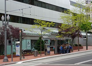
Convention Center station is a light rail station on the MAX Blue, Green and Red Lines in Portland, Oregon. It is the 8th stop eastbound on the current Eastside MAX, having not been built when the original line opened, in 1986. It was built to serve the Oregon Convention Center, which did not exist when the MAX line opened, and was completed and opened in the same month as the Convention Center, September 1990.

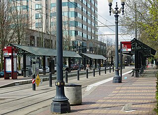
Old Town/Chinatown station is a MAX Light Rail station served by the Blue and Red Lines. It is located in the Old Town Chinatown neighborhood in Portland, Oregon and is currently the 6th stop eastbound on the Eastside MAX. It is also the last stop before crossing the Willamette River. It is next to the Portland Downtown Heliport. The station was previously also served by the Yellow Line, from 2004 to 2009, until that line's relocation to the Portland Transit Mall.

Mount Hood Avenue station is a light rail station on the MAX Red Line in Portland, Oregon. Located at the northern end of the Cascade Station development, it is the 2nd stop north on the Airport MAX. The street for which it is named, Mount Hood Avenue, is located about 1,200 feet (370 m) southeast of the station. Mount Hood is approximately 40 miles away from the station.

Overlook Park is a light rail station in Portland, Oregon, United States, served by TriMet as part of the MAX Light Rail system. It is the eighth station southbound on the Yellow Line, which operates between North Portland, downtown Portland and Portland State University. The staggered side platform station is situated between the intersections of Fremont Street and Overlook Boulevard along the median of North Interstate Avenue, near the Interstate Medical Offices of Kaiser Permanente and a park with the same name. It is one of three stations serving North Portland's Overlook neighborhood along with North Prescott Street and North Killingsworth Street. Overlook Park station opened on May 1, 2004, as part of the Interstate MAX extension. Trains serve the station for approximately 21 hours per day on a headway of 15 minutes during most of the day.

Rosa Parks is a light rail station on the MAX Yellow Line in the Arbor Lodge neighborhood of Portland, Oregon. It is the 6th stop northbound on the Interstate MAX extension. It was originally named North Portland Boulevard, but following the city's decision in fall 2006 to rename Portland Blvd. to Rosa Parks Way, TriMet indicated it would support the change by renaming the station, at a then-undetermined future date. The signs at the station continued to show the old name until Feb. 4, 2009, when a dedication ceremony was held, unveiling new signs renaming it as "Rosa Parks" station. On TriMet's maps and other media, the station is shown as "N Rosa Parks Way".

Delta Park/Vanport is a light rail station on the MAX Yellow Line in Portland, Oregon. It is the 9th stop northbound on the Interstate MAX extension and is in the area of Delta Park, formerly the site of the city of Vanport. It is located between Portland International Raceway on the west and Interstate 5 on the east and is at the north end of the Vanport Bridge, which spans the Columbia Slough and an industrial area.

Cascades is a light rail train station in the MAX Light Rail system. It is served by the Red Line and is located in Portland, Oregon; it is the third stop north on the Airport MAX section. When the line first opened, trains paused here in order to simulate a station stop for timetable purposes, but the stop was not announced nor were the doors opened. In January 2007, the stop officially opened to serve customers of Cascade Station.
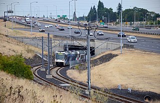
The I-205 busway was a partially built busway along the right-of-way of the Interstate 205 freeway in Portland, Oregon. Although it never opened as a busway, its right-of-way has been in use by light rail lines partially since 2001 and fully since 2009.

Southeast Main Street is a light rail station on the MAX Green Line in Portland, Oregon. It is the first stop southbound on the I-205 MAX branch, following the Green Line's split from the Red and Blue lines at the Gateway Transit Center.

Southeast Division Street station is a light rail station on the MAX Green Line in Portland, Oregon. It is the 2nd stop southbound on the I-205 MAX branch.

Southeast Holgate Boulevard is a light rail station on the MAX Green Line in Portland, Oregon. It is the 4th stop southbound on the I-205 MAX branch. The station is at the intersection of Interstate 205 and Holgate Boulevard. This station has a center platform, and has a park-and-ride facility on the west side.

Lents Town Center/Southeast Foster Road is a light rail station on the MAX Green Line in Portland, Oregon. It is the 5th stop southbound on the I-205 MAX branch. The station is at the intersection of Interstate 205 and Foster Road. It is located in the Lents neighborhood's town center business district. It also provides access to the Springwater Corridor, which was once a transit line to the suburbs and is now a dedicated bikeway through southeast Portland.

Southeast Flavel Street is a light rail station on the MAX Green Line in Portland, Oregon. It is the sixth stop southbound on the I-205 MAX branch. The station is located at SE Flavel Street, adjacent to Interstate 205, and has a center platform. Johnson Creek flows beneath the interstate and railway tracks, slightly north of the station.

Southeast Fuller Road is a light rail station on TriMet's MAX Green Line in Portland, Oregon, located between SE 82nd Avenue and Interstate 205. It is the 7th stop southbound on the Interstate 205 MAX branch. The station has a center platform and is surrounded by a park and ride facility.
Southwest 6th & Madison Street and City Hall/Southwest 5th & Jefferson Street stations are a pair of light rail stations on the MAX Green, Orange and Yellow Lines in Portland, Oregon. It is the fifth stop southbound on the Portland Transit Mall extension.

Kenton/North Denver Avenue is a light rail station on the MAX Yellow Line in Portland, Oregon. It is the 8th stop northbound on the Interstate Avenue MAX extension.
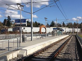
Southeast Tacoma/Johnson Creek is a light rail station and park and ride for the MAX Orange Line. Service began on September 12, 2015. It is the third stop northbound on the Orange Line. The station was built for residents of the Sellwood and Ardenwald neighborhoods of Portland and Milwaukie. The station is located adjacent to Oregon Route 99E and can be directly accessed by northbound traffic and by traffic from the portion of SE Tenino Street that connects SE Tacoma to SE Johnson Creek Boulevard.
