
The Metropolitan Area Express (MAX) is a light rail system serving the Portland metropolitan area in the U.S. state of Oregon. Owned and operated by TriMet, it consists of five color-designated lines that altogether connect the six sections of Portland; the communities of Beaverton, Clackamas, Gresham, Hillsboro, Milwaukie, and Oak Grove; and Portland International Airport to Portland City Center. Service runs seven days a week with headways of between 30 minutes off-peak and three minutes during rush hours. In 2019, MAX had an average daily ridership of 120,900, or 38.8 million annually. Due to the COVID-19 pandemic, which impacted public transit use globally, annual ridership plummeted, with only 14.8 million riders recorded in 2021.
TriMet, formally known as the Tri-County Metropolitan Transportation District of Oregon, is a public agency that operates mass transit in a region that spans most of the Portland metropolitan area in the U.S. state of Oregon. Created in 1969 by the Oregon legislature, the district replaced five private bus companies that operated in the three counties: Multnomah, Washington, and Clackamas. TriMet started operating a light rail system, MAX, in 1986, which has since been expanded to five lines that now cover 59.7 miles (96.1 km), as well as the WES Commuter Rail line in 2009. It also provides the operators and maintenance personnel for the city of Portland-owned Portland Streetcar system. In 2022, the system had a ridership of 53,889,500, or about 173,600 per weekday as of the fourth quarter of 2022.

Interstate 205 (I-205) is an auxiliary Interstate Highway in the Portland metropolitan area of Oregon and Washington, United States. The north–south freeway serves as a bypass route of I-5 along the east side of Portland, Oregon, and Vancouver, Washington. It intersects several major highways and serves Portland International Airport.

The MAX Blue Line is a light rail service in Portland, Oregon, United States, operated by TriMet as part of the MAX Light Rail system. It travels east–west for approximately 33 miles (53 km)—the longest in the network—between Hillsboro, Beaverton, Portland, and Gresham and serves 48 stations from Hatfield Government Center to Cleveland Avenue. The line carried an average 55,370 riders each day on weekdays in September 2018, the busiest of the five MAX lines. It runs for 221⁄2 hours per day from Monday to Thursday, with headways of between 30 minutes off-peak and five minutes during rush hour. Service runs later in the evening on Fridays and Saturdays and ends earlier on Sundays.

The MAX Red Line is a light rail service in Portland, Oregon, United States, operated by TriMet as part of the MAX Light Rail system. An airport rail link, it connects Beaverton, Portland City Center and Northeast Portland to Portland International Airport. The line serves 26 stations; it interlines with the Blue Line and partially with the Green Line from Beaverton Transit Center to Gateway/Northeast 99th Avenue Transit Center and then branches to the 5.5-mile (8.9 km) Airport MAX segment to Portland International Airport station. The Red Line carried an average 10,310 passengers per weekday in September 2021, the second-busiest MAX service after the Blue Line. Its trains run for 22 hours per day with headways of up to 15 minutes.

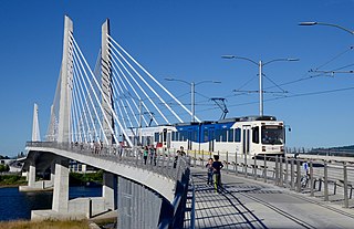
The MAX Yellow Line is a light rail service in Portland, Oregon, United States, operated by TriMet as part of the MAX Light Rail system. It connects North Portland to Portland City Center and Portland State University (PSU) with 17 stops from Expo Center station to PSU South/Southwest 6th and College station. The line travels from Portland Expo Center in the north, south to the Rose Quarter through a 5.8-mile (9.3 km) light rail segment along the median of Interstate Avenue. From the Rose Quarter, it crosses the Willamette River via the Steel Bridge and enters downtown Portland, where it operates as a northbound-only service of the Portland Transit Mall on 6th Avenue. Service runs for approximately 21 hours daily with a headway of 15 minutes during most of the day.

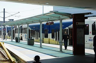
The Gateway/Northeast 99th Avenue Transit Center, commonly known as Gateway Transit Center, is a TriMet bus transit center and light rail station on the MAX Blue, Green and Red Lines in Portland, Oregon, United States. It is the 14th stop eastbound on the current Eastside MAX. This station is where all three lines split, with Blue Line trains proceeding east to Gresham, Green Line trains proceeding south to Clackamas, and Red Line trains proceeding north to Portland International Airport. When opened in 1986, it was the busiest station on the Portland–Gresham MAX line, the only line in the system at that time, and was the terminus of 11 bus lines. Currently seven bus lines serve the Gateway Transit Center.

Like transportation in the rest of the United States, the primary mode of local transportation in Portland, Oregon is the automobile. Metro, the metropolitan area's regional government, has a regional master plan in which transit-oriented development plays a major role. This approach, part of the new urbanism, promotes mixed-use and high-density development around light rail stops and transit centers, and the investment of the metropolitan area's share of federal tax dollars into multiple modes of transportation. In the United States, this focus is atypical in an era when automobile use led many areas to neglect their core cities in favor of development along interstate highways, in suburbs, and satellite cities.
Portland is "an international pioneer in transit orientated developments."
Portland International Airport, or just Airport on station signage, is a light rail station in Portland, Oregon, United States, served by TriMet as part of the MAX Light Rail system. It serves Portland International Airport as the eastern terminus of the Red Line, which connects travelers to downtown Portland and Beaverton. The station is attached to ground floor of the main passenger terminal, near the southern end of the arrivals hall and baggage claim area. It features a wedge-shaped island platform, just beyond which both tracks join because the section approaching the terminal is single-tracked.

Overlook Park is a light rail station in Portland, Oregon, United States, served by TriMet as part of the MAX Light Rail system. It is the eighth station southbound on the Yellow Line, which operates between North Portland, downtown Portland and Portland State University. The staggered side platform station is situated between the intersections of Fremont Street and Overlook Boulevard along the median of North Interstate Avenue, near the Interstate Medical Offices of Kaiser Permanente and a park with the same name. It is one of three stations serving North Portland's Overlook neighborhood along with North Prescott Street and North Killingsworth Street. Overlook Park station opened on May 1, 2004, as part of the Interstate MAX extension. Trains serve the station for approximately 21 hours per day on a headway of 15 minutes during most of the day.

The MAX Green Line is a light rail service in Portland, Oregon, United States, operated by TriMet as part of the MAX Light Rail system. It is 15 miles (24.1 km) long and serves 30 stations from the PSU South stations to Clackamas Town Center Transit Center; it connects Portland State University (PSU), Portland City Center, Northeast Portland, Southeast Portland, and Clackamas. The Green Line is the only service that shares parts of its route with the four other MAX services, sharing the Portland Transit Mall with the Orange and Yellow lines and the Banfield segment of the Eastside MAX with the Blue and Red lines. Southbound from Gateway/Northeast 99th Avenue Transit Center, it operates the Interstate 205 (I-205) segment through to Clackamas Town Center. Service runs for approximately 211⁄2 hours daily with a headway of 15 minutes during most of the day. It is the third-busiest line in the system, carrying an average of 19,160 riders per day on weekdays in September 2019.
The MAX Orange Line is a light rail service in Portland, Oregon, United States, operated by TriMet as part of the MAX Light Rail system. It connects Portland City Center, Portland State University (PSU), Southeast Portland, Milwaukie, and Oak Grove. The line serves 17 stations from Union Station/Northwest 5th & Glisan to Southeast Park Avenue and runs for 201⁄2 hours daily with a minimum headway of 15 minutes during most of the day. It averaged 3,480 daily weekday riders in September 2020.
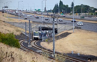
The I-205 busway was a partially built busway along the right-of-way of the Interstate 205 freeway in Portland, Oregon. Although it never opened as a busway, its right-of-way has been in use by light rail lines partially since 2001 and fully since 2009.

The Clackamas Town Center Transit Center is a bus transit center and MAX Light Rail station on the MAX Green Line, located in Clackamas County, Oregon, in the southeastern part of the Portland metropolitan area. It is the southern terminus for the I-205 MAX branch.

Southeast Main Street is a light rail station on the MAX Green Line in Portland, Oregon. It is the first stop southbound on the I-205 MAX branch, following the Green Line's split from the Red and Blue lines at the Gateway Transit Center.

Southeast Powell Boulevard is a light rail station on the MAX Green Line in Portland, Oregon. It is the 3rd stop southbound on the I-205 MAX branch.

Southeast Holgate Boulevard is a light rail station on the MAX Green Line in Portland, Oregon. It is the 4th stop southbound on the I-205 MAX branch. The station is at the intersection of Interstate 205 and Holgate Boulevard. This station has a center platform, and has a park-and-ride facility on the west side.

Lents Town Center/Southeast Foster Road is a light rail station on the MAX Green Line in Portland, Oregon. It is the 5th stop southbound on the I-205 MAX branch. The station is at the intersection of Interstate 205 and Foster Road. It is located in the Lents neighborhood's town center business district. It also provides access to the Springwater Corridor, which was once a transit line to the suburbs and is now a dedicated bikeway through southeast Portland.

Southeast Flavel Street is a light rail station on the MAX Green Line in Portland, Oregon. It is the sixth stop southbound on the I-205 MAX branch. The station is located at SE Flavel Street, adjacent to Interstate 205, and has a center platform. Johnson Creek flows beneath the interstate and railway tracks, slightly north of the station.

Southeast Bybee Boulevard is a light rail station in Portland, Oregon, United States, served by TriMet as part of the MAX Light Rail system. It is the 14th station southbound on the Orange Line, which operates between Portland City Center, Southeast Portland, and Milwaukie. The grade-separated, island platform station adjoins Union Pacific Railroad (UP) freight tracks to the east and McLoughlin Boulevard to the west. Its entrances are located on the Bybee Bridge, which spans over the platform and connects Portland's Sellwood-Moreland and Eastmoreland neighborhoods. Nearby places of interest include Westmoreland Park, Eastmoreland Golf Course, Crystal Springs Rhododendron Garden, and Reed College.
