Spider Lake, Wisconsin

Last updated

Spider Lake, Wisconsin
WIMap-doton-Spider Lake.png
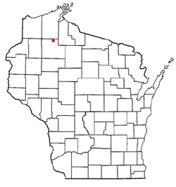
Location of Spider Lake, Wisconsin
Coordinates: 46°5′50″N91°7′48″W / 46.09722°N 91.13000°W / 46.09722; -91.13000
Country Flag of the United States.svg  United States
State Flag of Wisconsin.svg  Wisconsin
County Sawyer
Area
  Total108.9 sq mi (282.0 km2)
  Land99.3 sq mi (257.1 km2)
  Water9.6 sq mi (24.9 km2)
Elevation
[1]
1,411 ft (430 m)
Population
 (2000)
  Total391
  Density3.9/sq mi (1.5/km2)
Time zone UTC-6 (Central (CST))
  Summer (DST) UTC-5 (CDT)
Area code(s) 715 & 534
FIPS code 55-75450 [2]
GNIS feature ID1584185 [1]

Spider Lake is a town in Sawyer County, Wisconsin, United States. The population was 391 at the 2000 census.

Contents

Geography

According to the United States Census Bureau, the town has a total area of 108.9 square miles (282.0 km2), of which, 99.2 square miles (257.1 km2) of it is land and 9.6 square miles (24.9 km2) of it (8.84%) is water.

Demographics

As of the census [2] of 2000, there were 391 people, 186 households, and 137 families residing in the town. The population density was 3.9 people per square mile (1.5/km2). There were 776 housing units at an average density of 7.8 per square mile (3.0/km2). The racial makeup of the town was 96.93% White, 0.26% African American, 1.02% Native American, 0.51% from other races, and 1.28% from two or more races.

There were 186 households, out of which 13.4% had children under the age of 18 living with them, 66.7% were married couples living together, 4.3% had a female householder with no husband present, and 26.3% were non-families. 22.0% of all households were made up of individuals, and 10.2% had someone living alone who was 65 years of age or older. The average household size was 2.07 and the average family size was 2.39.

In the town, the population was spread out, with 12.5% under the age of 18, 1.0% from 18 to 24, 23.8% from 25 to 44, 33.5% from 45 to 64, and 29.2% who were 65 years of age or older. The median age was 53 years. For every 100 females, there were 106.9 males. For every 100 females age 18 and over, there were 112.4 males.

The median income for a household in the town was $37,396, and the median income for a family was $47,813. Males had a median income of $30,156 versus $26,094 for females. The per capita income for the town was $26,461. About 1.9% of families and 4.2% of the population were below the poverty line, including none of those under age 18 and 5.4% of those age 65 or over.

Related Research Articles

<span class="mw-page-title-main">Sylvania, Alabama</span> Town in Alabama, United States

Sylvania is a town in DeKalb County, Alabama, United States. It incorporated in October 1967. At the 2010 census the population was 1,837, up from 1,186 in 2000. Sylvania is located atop Sand Mountain. Sylvania has its own Post Office, established in 1996 and located at 9596 Blue Pond Blvd. W.

<span class="mw-page-title-main">Midfield, Alabama</span> Town in Alabama, United States

Midfield is a town in Jefferson County, Alabama, United States, located two miles south of the Birmingham suburb of Fairfield. It incorporated in 1953. As of the 2010 census, it had a population of 5,365.

<span class="mw-page-title-main">Clear Lake, Indiana</span> Town in Indiana, United States

Clear Lake is a town located in the northeast corner of Steuben County, Indiana, in Clear Lake Township. As such, is the northeasternmost community in the State of Indiana. The population was 339 at the 2010 census.

<span class="mw-page-title-main">Portage Lake, Maine</span> Town in the state of Maine, United States

Portage Lake is a town in Aroostook County, Maine, United States. The population was 359 at the 2020 census.

Athens is a town in Somerset County, Maine, United States. The population was 952 at the 2020 census.

<span class="mw-page-title-main">Montville, Maine</span> Town in the state of Maine, United States

Montville is a town in Waldo County, Maine, United States. The population was 1,020 at the 2020 census.

Charlotte is a town in Washington County, Maine, United States. The town was named for the wife of legislator William Vance. The population was 337 at the 2020 census.

Verona Township is a township in Faribault County, Minnesota, United States. The population was 391 at the 2000 census.

<span class="mw-page-title-main">Tribbey, Oklahoma</span> Town in Oklahoma, United States

Tribbey is a town in Pottawatomie County, Oklahoma, United States.The community was named for Alpheus M. Tribbey, landowner. The population was 391 at the 2010 census, a 43.2 percent gain from the figure of 273 in 2000.

<span class="mw-page-title-main">West Logan, West Virginia</span> Town in West Virginia, United States

West Logan is a town along the Guyandotte River in Logan County, West Virginia, United States. The population was 400 at the 2020 census. For unknown reasons, some sources report West Logan to lay west of the county seat at Logan, attributing to this fact the name.

<span class="mw-page-title-main">Fairview, West Virginia</span> Town in West Virginia, United States

Fairview is a town in Marion County, West Virginia, United States. The population was 374 at the 2020 census.

<span class="mw-page-title-main">White Hall, West Virginia</span> Town in West Virginia, United States

White Hall is a town in Marion County, West Virginia, United States. The population was 706 at the 2020 census. Incorporated in 1989, White Hall is adjacent to the county seat, Fairmont, and is part of the Fairmont, West Virginia, Micropolitan Statistical Area. White Hall has many different stores and restaurants.

<span class="mw-page-title-main">Anawalt, West Virginia</span> Town in West Virginia, United States

Anawalt is a town in McDowell County, West Virginia, United States. At one time it was known as Jeanette. It is named in honor of James White Anawalt, who was then manager of Union Supply Company, a subsidiary of the United States Steel Company. The population was 186 at the 2020 census. Coal mining was the town's chief industry.

<span class="mw-page-title-main">Sophia, West Virginia</span> Town in West Virginia, United States

Sophia is a town in Raleigh County, West Virginia, United States. It was incorporated in 1912. The population was 1,124 at the 2020 census.

<span class="mw-page-title-main">Keystone, Wisconsin</span> Town in Wisconsin, United States

Keystone is a town in Bayfield County, Wisconsin, United States. The population was 378 at the 2010 census. The unincorporated community of Ino is located in the town.

<span class="mw-page-title-main">Mayville, Clark County, Wisconsin</span> Town in Wisconsin, United States

Mayville is a town in Clark County in the U.S. state of Wisconsin. The population was 919 at the 2000 census.

<span class="mw-page-title-main">Dairyland, Wisconsin</span> Town in Wisconsin, United States

Dairyland is a town in Douglas County, Wisconsin, United States. The population was 186 at the 2000 census. The unincorporated communities of Cozy Corner, Dairyland, and Moose Junction are located in the town.

<span class="mw-page-title-main">Harrison, Grant County, Wisconsin</span> Town in Wisconsin, United States

The Town of Harrison is a town in Grant County, Wisconsin, United States. The population was 497 at the 2000 census. The unincorporated community of Cornelia is located in the town.

<span class="mw-page-title-main">Skanawan, Wisconsin</span> Town in Wisconsin, United States

Skanawan is a town in Lincoln County, Wisconsin, United States. The population was 391 at the 2010 census, up from 354 at the 2000 census.

<span class="mw-page-title-main">Preston, Trempealeau County, Wisconsin</span> Town in Wisconsin, United States

Preston is a town in Trempealeau County, Wisconsin, United States. The population was 951 at the 2000 census.

References

  1. 1 2 "US Board on Geographic Names". United States Geological Survey. October 25, 2007. Retrieved January 31, 2008.
  2. 1 2 "U.S. Census website". United States Census Bureau . Retrieved January 31, 2008.